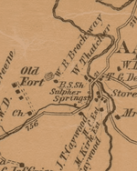
✅ SOLVED 1897 Map decipher needed

1320

Silver Member
Dec 10, 2004
3,436
2,311
East Central Kentucky

Attachments

  • Arrons Run.PNG
    Arrons Run.PNG
    112.3 KB · Views: 125
Looks like the drawing is the fort to me, BS Sh is probably an abbreviation for a family name, looks like the full name would not fit in the space provided by the dot (the home), thats how i would read it.
 

Upvote 0
Black Smith shop
 

Upvote 0
Looks like the drawing is the fort to me, BS Sh is probably an abbreviation for a family name, looks like the full name would not fit in the space provided by the dot (the home), thats how i would read it.

I'm thinking the same regarding it being the Fort but why such an odd drawing for it? Could it be because the structure was stone and wood?
 

Upvote 0
Tedyoh got it, it is the first 2 initials of the land owners name, the last name is blocked out by the roadway intersection. It could be for example something like B. S. Shoals. It is not quite like an old plat map but it is using the same type of boundary names.
 

Upvote 0
Tedyoh got it, it is the first 2 initials of the land owners name, the last name is blocked out by the roadway intersection. It could be for example something like B. S. Shoals. It is not quite like an old plat map but it is using the same type of boundary names.

BS Sh appears approximately 20 times on this particular map, blacksmith makes more sense...not saying that you or Tedyoh are wrong though.
 

Upvote 0
I'm going with black smith also. I have a civil war era map and it has BS all over the place. I first thought it stood for boys school, but soon proved that was not it.
 

Upvote 0
I'm going with black smith also. I have a civil war era map and it has BS all over the place. I first thought it stood for boys school, but soon proved that was not it.

I thought the same regarding "school" but as I looked the map over closer, schools are abbreviated as sc.
 

Upvote 0

Top Member Reactions

Users who are viewing this thread

Back
Top