Tumacacori Mission Mines RE: Sister Micaela Molina Document

gollum

Gold Member
Jan 2, 2006
6,770
7,724
Arizona Vagrant
Detector(s) used
Minelab SD2200D (Modded)/ Whites GMT 24k / Fisher FX-3 / Fisher Gold Bug II / Fisher Gemini / Schiebel MIMID / Falcon MD-20
Primary Interest:
All Treasure Hunting
OK, here's something for you experts to scratch your collective heads over! ;D ;D

There is a well known string of Spanish Missions just North of Nogales, Arizona. One of those missions is named Tumacacori. There were several mines associated with it. The location of the current Tumacacori Mission is not where the original was.

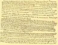
In researching another possible location, I came across a reference to a document. Long story short, there was a Nun in Seville at the Spanish Archives. She came across a document with a possible date of 1658. I have provided a copy of the document, an exact transcription of the document, and an exact translation of the document, and an analysis of the document (by the NPS) giving specifics as to why they believe it is a fake.

The reason I'm doing this is because the National Park Service states that the document is a fake. One person, at least, believes the document is authentic. So much so, that he has spent about $90,000.00 and 19 years of his life following this documents' directions. He has hired heavy equipment and actually found two tunnels at the site. He believes he knows the location of the third, where the motherlode is buried.

If it is a fake (and that is very possible), I have seen and heard of people doing this with old maps having to do with The Lost Dutchman's Mine. Spend their entire lives following their map, and die poor, knowing they were just about to find it every day, for 50 years.

Since there are a few people in this forum with more some experience in Colonial Spanish Documents, Castillan Language Speech, and Writing, I figured we could figure this thing out.

Thanks-Mike
 

Attachments

  • Molina Doc.JPG
    Molina Doc.JPG
    123.1 KB · Views: 7,557
This first section is the introduction.

The Forged "Molina Document"
Only in recent years has there been a facsimile of a document which treasure authors have come to call the "Molina Document." The name comes from a story that someone made up about a non-existent Spanish Nun named Micaela Molina, who supposedly brought the document from Spain and then translated it. It is interesting that her translation of it makes some of the same mistakes that John D. Mitchell made in his 1933 English version of the document. In fact, it appears that the document, or facsimile of it, did not even exist in 1933 but was written afterwards to give credence to what Mitchell said at that time. In 1933 he claimed that he got his English translation from a document that an "old Mexican" had given him some twenty years previously. By 1953, however, he had contrived several stories out of the one document and credited the information in it to:
1) "...stories told by some of the descendants of the Spanish Conquistadores;"
2) "...an old document said to have been copied from church records in Spain;"
3) "...many old Spanish documents;"
4) "...an old volume in the Arizona State Library at Phoenix;"
5) "...old church records brought from Spain ... by Don Santiago Diaz, former governor of Lower California."
Now, other treasure authors have connected the non-existent "Sister Molina" to the imaginary "Santiago Diaz," who was never a governor of Baja California, as being related. The story gets more outlandish with each passing generation. The one thing that becomes obvious in tracking the so-called "Molina Document" is that it was written either "by," "for," or "to fool" John D. Mitchell.
Click on the blue word to see the actual facsimile of page one of the forged document. If you have trouble reading it you can go to an exact, word-for-word, transcription that maintains all the original punctuation and spelling. Or you can click on translation to see exactly what it says in English. A full analysis of the forgery is also included which shows why it is not an old Spanish document or anything that even resembles one.
 

This section is the exact transcription.

Exact Transcription of Page One

Redotero - año MDXCVIII - MDCLVIII - este Redotero pertenece a Temacacury: la Mina de Temacacury
llamada la Vigen d. Guadalupe. Esta una legua medina comensando de la puerta Mayor del Templo al Sr. y de la
agua de San Roman mide a la Siniestra M. ochocientas Vrs al N. y como CCDTD vrs. antes de llegar a la mina hay una piedra
negra macada con cincel con estas marcas por debajo de la piedra (picture of inscription) de la esta el Tesoro este significa
las letras, y como a XX.- Vrs de la Piedra adelante, esta un monumento chico rumbo al Sr. el P.te de la Mina
hay dos picachos que fueron derrunbados sobre la Mina sin mas avada que puesta la Polvora en las
rajaduras de las piedras, quedo la hueya borrada para siempre pasando por sobre las piedras no se sabe
donde - esta este lugar dentro de la Mina esta un patio que mide L. Vrs en cuadro y en este lugar
esta el Tesoro de nuestras Misiones. En medio del " " esta la boca de la Mina adentro y fuera quedo
el Tesoro: estan MMDCL. Crgs. de plata Sellada y DCCCCV. de oro y plata que son XL.
millones. el oro fue traido de la Siera de Guachapa de las sercanias de Tubaca: seguid
adalante en la misma direcion del Sur.)
Como a III. Leguas de la Mina de nestra Sra. de Guadalupe hay I. Puerto que se llama de los Janos
rumbo al S. de aqui sale I. Arrollo y desemboca al Rio de Sta. Cruz, la Mina esta a la sinestra del Puerto
abajo del Puerto hay XII. Rastras y XII. Patios. La mina tiene I. Tonel de tres cientas Vrs. de largo y el tonel
tiene el nombre de la Puricima Concepcion gravad, con cincel el Tonel corre al N. y a XX. Vrs. tiene I. Tonelito de
cien Varas, al Pte el metal es amarillo metal que tiene mita de plata y quinta parte de oro hay unos seniceros
cincuenta Vrs. de la puerta de la Mina al rumbo del N. se encontranron planchas de plata virgen
desde una libra hata V.@s esta Mina esta tapada con una puerta de cobre tiene unos enormas aldabones
este cobre fue traido de la Sierra de Guachapa de las cercanillas de Tubaca y fundido en Toma=
=cacury y han llevada la Prta. En I. Rastra, con Buelles a la Mina. Año MDXLVIII. se trabajo y se tapo
en - MDCXLVIII como marca el libro del trabajo de la mision.
De la Mina de la Purima Concepcion a la Mina d. Nera. Sra. de Guadalupe hay III. leguas como a la mita
del camino a. la misma direccion esta la Mina llamada de los Opates - esta tiene I tonel de cuatro=
=cinetas Vrs. y al S. en la misma direccion los metales son calichosos y desde trescietas Vrs. se
cortaba con cajadora y de la boca de la Mina corre u. mesa muy larga para la salida del Sol al lado del Pte.
hay I. Cañon muy grande y tiene una marca de barreno. Qu. Tiene media Vra. de ondura parandose al lado
del Sur. Se ve la marca al otro lado del cañon rumbo al N. de esta marca hay I. Legua a la Mina de los
Opates de Tomacacury. esta la mak. para Pte. al otro lado de la Sierra esta la mina de Ntra. Sra. de
Guadpe esta marcado por P.S. R. el XII del mes de Dcbr. de MDXVIII. Fue allada eta Mina por un mia
 

This section is tre translation.

Translation of Page One

Directions - year 1598 to 1658 - these Directions pertain to Tumacácori: The Mine of Tumacacori
called the Virgen of Guadalupe. It is a league and a half, beginning at the main door of the temple on the south. From the
Waters of San Ramón measured to the left (it is) 1800 rods to the north. Some 1200 rods before reaching the mine is a black
rock marked with a chisel with these marks on the bottom of the rock . 1200 rods from the cross is the treasure. This is
what the writing means. Some 20 rods in front of the rock is a small monument. In a southwest direction from the mine
are two rock outcroppings that were knocked down over the mine without more jarring than the placement of gunpowder in
the cracks of the rocks, leaving the track obliterated forever. Going over the rocks no one would know
where this place is. Inside the mine is a room that measures 50 rods square and in this place
is the treasure of our missions. In the middle of the room is the mouth of the mine, the treasure being (both)
inside and outside of it: There are 2650 loads of sealed silver and 905 of gold, and there are 40
million in (unsealed) silver. The gold was brought from the Sierra de Guachapa in the vicinity of Tubac: continue
forward in the same southerly direction.
Some three leagues from the mine of Nuestra Señora de Guadalupe what is called "Pass of the Janos."
In a direction to the south from here, an arroyo starts that empties into the Santa Cruz River. The mine is to the left of the pass.
Below the pass are 12 ore crushers and 12 smelters. The mine has one tunnel of 300 rods in length and the tunnel
has the name of La Purísima Concepción engraved on it with a chisel. The tunnel runs north and at 20 rods a small tunnel of
one hundred rods intersects it, running west. The ore is yellow - ore that is half silver and a fifth part gold. There are some slag
pits fifty rods from the door of the mine going north. They found chunks of pure silver
weighing from one pound to 5 arrobas (125 pounds). This mine is sealed by a copper door that has some enormous handles.
This copper was brought from the Sierra de Guachapa in the vicinity of Tubac and smelted in Tuma-
cácori, and the door was carried to the mine on a sledge by oxen. The year 1658. They worked and covered it
in 1658 as recorded in the book of works of the mission.
It is three leagues from the mine of La Purísima Concepción to the mine of Nuestra Señora de Guadalupe. About halfway
down the road in the same direction is what is called The Mine of the Opatas. This mine has one tunnel of four
hundred rods and running south along the same course. The ore is mixed with pebbles and after three hundred rods is
cut off by a trench. A very large tableland runs from the mouth of the mine toward the setting sun. On its west side
is a very large canyon ending on the south side. It has a bore mark that is a half-rod deep. Standing on the south side,
you can see the mark on the other side of the canyon. Going one league north from this mark is the Mine of the
Opatas of Tumacácori. This is the mark. To the west on the other side of the sierra is the mine of Nuestra Señora de
Guadalupe. It is marked by Father S--- R--- on the 12th of the month of December in 1518. This mine was found by a =
 

Why the "Molina Document" is a Counterfeit


Handwriting style​
The so-called "Molina document" is written in a printed form of handwriting, something that is just not seen in the Spanish colonial era. Although there were, of course, printed books, the populace always wrote in a cursive style. In this forgery, letters are printed in modern style, although the forger tried on occasion to make some of them look archaic. Unfortunately, his lack of consistency gives him away. One glaring example of this is the way the forger made his "r's," as in the word "borrada." Spaniards of the colonial period universally made "r's" that looked like "x's, but this writer's "r's" are consistantly executed like modern printed "r's." A comparison of handwriting styles of the sixteenth, seventeenth, and eighteenth centuries graphically shows this "document" to be a phony.

Format​
The counterfeit is written in a "landscape" format, something totally unheard of in the Spanish colonial era. The variation in size of the letters and weaving lines point to someone besides a Spaniard having written it. Those who could write in the colonial era were taught to keep their lines very straight and the size of their letters uniform. They took great pride in their ability to write "properly." Probably one of the reasons they never wrote in the landscape format is because shorter lines are much easier to keep straight.

Roman numerals​
No Spanish document ever used Roman numerals in the text. This forger used them at least twenty-six times in this one short document. Sometimes in extremely rare cases one will see Roman numerals used in headings or titles of books, but the only time they are ever seen even written on the same page as text is in documents from the 1500's, and those numerals are written in a style that is totally foreign to anything we are used to today.

CCCDTC​
The forger is a bit confused when he speaks of "CCDTC varas." That is a strange way to write possibly either 800 or 1200. He wrote it as a measurement once. Then he put ditto marks under it in the next line to reiterate the distance, and then it is written the same to show the symbol that was supposed to be chiseled with the cross on the underneath side of a black rock.


MDXVIII​
Another problem associated with the Roman numerals in this counterfeit document can probably be attributed to oversight, but because the forger left the "L" out of the date at the bottom of the document it changes the date that the imaginary Father S--- L--- supposedly marked the mine in December of 1518. It is a known historical fact that Spaniards were not in northern Sonora in 1658, but 1518, before they ever marched on Mexico City, is ridiculous. John D. Mitchell misread "MDXVIII" and published it as 1508 and most treasure authors, rather than reading the actual Roman numeral have simply reiterated his mistake. One author, however, caught the mistake and blames it on the illusive fictional "Nun."

Redotero​
The very first word of this fraudulent "Spanish" document is a clear indicator that it was not written by a Spaniard or in the Spanish colonial period. Redotero is a Mexican colloquialism that dates this document to the 19th century or later. It is derived from the verb "derrotar" (redotar) which has to do with plotting a course of direction or action. (See Francisco J. Santamaria's "Diccionario de Mejicanismos," and "Diccionario de la Lengua Española por el Real Academia Española.")


Río Santa Cruz​
The river that is today known as the "Santa Cruz River" was not known by that name in the Spanish Period. It was after the establishment of the town of Santa Cruz, located in present-day Sonora, that the river's name changed from "Santa María" to "Santa Cruz." In fact, John Mitchell's first book, printed in 1933, which gave an English translation of this counterfeit document, used the words "old town of Santa Cruz" rather than "Santa Cruz River." He evidently learned that the "old town" was not so old after all, and changed the designation to river rather than town in his 1953 book. Regardless, the useage of the words "Río Santa Cruz" date this forgery, whether original or copied, to a time after the Spanish colonial period and long after the Jesuits were expelled from New Spain.

Patio​
The first time the word patio is used in this forgery, it is used to describe the main room inside the mine. That room was called the criadero in Spanish colonial days. You will not see patio used in such a way.
The word patio was never used in the colonial era to describe a smelter nor the amalgamation process. Nor was the amalgamation process ever called the "Patio Process" by Spaniards, Mexicans, or any other Spanish-speaking community. Patio Process are the words coined by "Anglos" to describe the process that Spaniards called "hacienda de sacar plata por beneficio de azogue." Smelters, in those days, were called simply haciendas or haciendas de sacar plata - again dating this document to the the Arizona territorial period and giving proof positive that an English speaker wrote it, not a Spaniard


Túnel​
Misspelled in this "document" as "tonel." This is a word that was never used in the Spanish era to describe a horizontal mineshaft. The word in useage then was cañon. Túnel is not really even modern Mexican useage. It is obviously an "Anglo" coming up with the only word he knows.

Cañón​

Here is one place where our forger really gets himself into trouble. He uses cañón to describe a "canyon" when, as stated above, it was universally used by Spanish miners to describe a "horizontal mine shaft." The word used here on the frontier to describe a "canyon" in the days of the Spanish was cajón, although on rare occasions one does see the word "cañada." Nobody but a modern Anglo would confuse the useage of these words.


Ceniceros​
Slag piles were universally called grasseros or escoriales by Spanish colonial miners. Once again, an obvious mistake showing this is not a "Spanish" document. The word cenicero is actually an ash pit, something very different than what our "Anglo" forger is trying to describe here.

Abbreviations​

Our forger obviously had access to some true old Spanish documents and was somewhat familiar with their abbreviations - just not quite familiar enough to be convincing, however. He is not consistent with his superscripts and has no real understanding of what should be placed in superscript status. He hits a few on the mark but really shows his ignorance of Spanish abbreviations and marks himself as an English speaker when he abbreviates Diciembre (December) as "Dcbr." and and sur (south), in one instance, as "Sr." Universally, the Spanish abbreviation for December ends in "re," whether superscripted or not. And no Spaniard would ever abbreviate south as "Sr." That was and still is the universal abbreviation for Señor. Another big mistake the forger made that no true writer of an ancient Spanish document would have done, is the abbreviation of varas (rods) as Vrs. The word varas as contained in real Spanish documents is universally abbreviated with a superscript "s" or "as," but certainly never "rs." One thing that he got right, and it leads one to believe that he had copies of some of the original Planchas de Plata documents, is his useage of "@" to designate arroba. However, this is another place where the evolution of the so-called Molina document can be traced, showing that it is a forgery that evolved over the years into something quite different than what it was when the idea first surfaced. Mitchell, in his original 1933 book as well as the 1953 edition, gives the supposed English translation as saying "weighing from 25 to 250 pounds each. Conrotto in his 1955 edition quotes Mitchell. Oliver, who reproduced a facsimile of the forgery in his book in 1991, says "from 1 pound to 125 pounds." Thompson, who also reproduced a facsimile in his 1999 edition, says "slabs of silver weighing 250 pounds each." The original forgery, itself, actually says "from one pound to five arrobas." An arroba being 25 pounds, five arrobas
would have meant that the slabs of silver weighed "from 1 to 125 pounds." Regardless of what the the actual amount is supposed to be, the more authors that are compared to the supposed original, the more of a sham the whole story becomes.


Color and consistency​
These color and consistency descriptions of the ore, and the forger's descriptions of the miners having found planchas de plata fifty rods into the Purísima mine are very suspicious of having been copied from the 1736 planchas de plata documents. Unfortunately, he didn't understand his geology. Horn silver, like that found in the 1736 discovery in Sonora, is found on or very near the surface of the ground, not in the depths of a mineshaft.

Misspellings​
Every ancient Spanish document, without exception, has spelling errors in it. Obviously, the forger of this document was aware of that fact and took pains to make sure he didn't spell everything correctly. He hits the mark well with his misspellings of such words as “hondura,” “bueyes,” "arroyo,"and “Tubac,” but his rendition of others, like “Tumacácori,” “San Ramón,” and “Opatas” are absurd. Nearly every spelling error, or what we would call a spelling error in our day, made by colonial Spaniards was due to the lack of spelling rules and the writer’s lack of understanding of the few there may have been. Since they wrote by phonetics, one can rightly expect the word to sound correct when spoken. For example, Tumacácori being an O’odham word the “T” was closer to a “tyu” sound, and in the native useage of the word the “i” was not always included. So, you often see it spelled “Thumacacor,” Chumacacor,” or “Chumacacori,” but never anything as outlandish as our forger’s spelling of it. And his ending it with a “y” reveals his total lack of understanding of ancient Spanish!
No colonial Spaniard would have ever misspelled the name of the beloved Saint Raymund (San Ramón) by confusing it with the commonly used twentieth century Mexican given name “Roman.” Although Roman was a rather obscure surname in the Spanish colonial days, it was not used as a given name. The same is true for anyone living here when the Opata Indians were still in existence. They would have never misspelled the name to read “Opate.”
Other misspellings also point to an English-speaker rather than a Spaniard having made the mistake: like leaving an "r" out of sierra, the "o" out of grabado, and the "r" out of virgen.


Letters​
One thing that stands out about the Mine Document that destroys any semblance of authenticity is its lack of the use of the letter “z” and its extensive use of the letter “c.” A modern document would, and by modern spelling rules, should have all those “c’s.” An ancient Spanish writer, however, would have exchanged about eighty percent of them for “z’s.” Or, if this were truly a sixteenth century document, some of those "c's" would have been "cedillas," or Greek "z's ("Ç").

Grammar​

From a grammar standpoint, the first thing that jumps off the page at the reader indicating that this writer is an "Anglo" is his useage of "la agua de San Roman." Agua is a masculine word even though it would appear to an English speaker to be feminine. Spanish speakers grow up with "el agua" and would not make that mistake.
The next obvious characteristic of our forger is that he knows how to use the verb estar, but few others - a common problem with people learning a new language. And, he is careful to write in present tense most of the time so he doesn't have to conjugate it very much. One of his more glaring errors along these lines is in the last line of the document where he says "It is marked by Father S--- R---..." (está marcado por Padre S--- R---...). The present tense, "it is" is poor grammar in anybody's language, but even if he meant to use the present, estar is not the verb a Spaniard would have used. A Spanish speaker would have said hubo marcado por Padre S--- R--- (it was marked by Father S--- R---). These are mistakes that only an English-speaker would make. Regardless of the Spanish speaker's education, he would not make those kinds of errors.
 

Hola Gollum: I find that I am in disaggreement with some of the author's interpretations on the document. Can you send a copy by em for me? - since it is apparantly a public document, there should be no prob with secrecy. It isn't too clear in my monitor.

RealdeTayopa@hotmail.com

It prob. IS a false document, but not a forgery. A forgery is a copy of an existing document, but then if it is someones copy of the orig document?, --------..

Join me in a candle lit, good music, wine guzzling bit of interpretation gypsy? Sorry Doc, yer basic physiological structure precludes you.

Tropical Tramp
 

The author is the National Park Service. The guy who has spent all the money thinks the NPS is lying about the document to keep other TH'ers out of the area.

No problem. Check your email.

Mike
 

HOL A Gallum:

Preliminary evaluation on the 'why the Molina document is a forgery"

A) Hand writing style, verbs, names, dates, etc etc, ? Who says that "this" particular document was written in the aforementioned period by a fluent Spaniard, it could easily have been done later by one of another nationality doing research or by copying a chance find.?

I personally have many copies of documents, that both I, and others have made, some are unreadable. I have no idea if this is a faithful copy of her original letter or what. I can only assume that another made it later in which case when? Obviously the copiers personal ideas, while interpreting ,will be evident in it, we all do unless we are striving for a perfect copy word for word.

This could easily explain the so called different terms in mining etc, also the others .

Putting the pieces together, I have to assume that this was a copy of the original document /letter by someone that was not of Spanish decent and of that period.

In no way does this disqualify this document, on the contrary, it may have great value both historically as well as financially , and should be persued, especially if certain signs or land marks are found through this document.

Agreed Doc?

G) "Patio" was used in the 1500's as evidenced in the translation of Agricola's book which was THE mining text of that period and extensively used by the Spanish.

H) tunel, Canon, and ceneceros were also used in those days by the miners, also from Agricola..

I have documents on Tayopa which are obviously copies which require a OUIJI board to interpret, but once done, have shown a high degree of useable data, probably the same exists for this document.

In the case of Tayopa, some were instrumental in my rediscovering this fabulous part of Western Legend and history, which I now own.

I would suggest doing some preliminary foot research to see what physical land marks you can come up with to semi verify the docuent - remember, it was written in Europe so the writer had no knowldege of the local terrain - if any can be found, then use this data as suggestive proof to back up your new request for the permision.

I will send a corrected intrpretation on the document later, the english version shown seems to have a few literal ones which are not completely correct.

Tropical Tramp


Joseph Curry

Real de Tayopa@hotmail.com

Tayopa, Mexican title no's 200480, 207481
1200 hectares
 

Thanks Jose.

Looking forward to seeing the corrected version of this document. If the corrections are in the distances, directions, or locations, that would be of enormous interest.

Funny thing is. I actually have a picture of what appears to be an Aztec Looking Carving of either a Jaguar or Leopard. Amazing area.

Mike
 

OK. I'm stumped. How do I access the archives? DUUUUUHH!

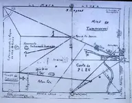
Thanks for the info BB. Here is the map as well.

Mike
 

Attachments

  • molinamap.jpg
    molinamap.jpg
    107.9 KB · Views: 6,546
> I was able to locate the master Map far from that area carved in rock <

I spoke with a guy on the phone some 7 years ago that had lived just north of the Tumacacori Mission.
He and a friend were hiking north of it and found a rock between two washes that looked strange.
After they studied it for a while they realized that it was a carved map of the mountian range with all the trails carved into it. This was before the Interstate went in. He took pictures of it and was going to get back to me but never did. At that time he was living in Arkansas. I would loved to have seen the pictures.<G>
 

This map actually looks like it should be folded in places to be read. A couple of the place names don't match up to known locations unless folded (origami treasure map). I have a story from the 1940's from a guy who found the Opatas Mine (played out), and from there, they found the Prue Conception. They took eight hundred bars of various types out, blew the entrance, and never went back. It all started in earnest when they found an old mission that was built on an Aztec Temple. Black and White Pics of many of the bars. Mostly dated from about 1701.

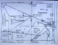
A problem I'm having is getting a good copy of the map. I can make out some things, but much of it is unreadable. Here is what I have so far:
 

Attachments

  • molinamap1.jpg
    molinamap1.jpg
    123 KB · Views: 6,008
Black Beard said:
Hello Mike,

You seem to know a lot about the Map. True, it was folded a certain way.
I own high resolution images of the original.

It came from a Museum in Mexico and was copied on their copy machine that wasn't very good.
It was then cleaned up in photoshop and had some lines and text removed in case it ever went public by another Treasure Hunter and his group that has been searching for years. At least they showed me where not to look.
I first started searching in their area and soon discovered the map was set up to take you to the old location of the original Vista of Tumacacori. And then I discovered it was not in the area you would think it was in. The clues are in the Molina Document. I've aleady talked about some of them on here.

What was removed from the Map I have no clue. All that you need is there on the Map though and since it is all symbolic language and it matters not. In the field you will find what you need to to put it together. Just walk in my shoes for over three years and you will have the answers to the Map and Document. Of course it helps to know where to start following the Trails from.

I think the person your referring to in 1940 is John Mitchell. He wrote many books on treasure and a couple of different versions were of the Opata story. Have you ever heard of the Guy who found the Bars back in 1984 around Arivaca AZ? 220 Pounds of Gold Dore Bars stamped now that was a Treasure!! He's the Man who taught me the basics and who's stories to believe from around that time frame.

BB

Is that other treasure hunter you mention Gary Oliver?

I've gone back and forth with him via email a bunch of times. He truly believes that the library or main vault is right at the base of the cliff w/cross. He has spent untold money (about $90K to date) digging in that area. I have his book, and he did get into a couple of shafts. I think Mr. Oliver has one critical flaw. Nowhere in his book, does he make mention of most of the monument rocks or carvings. He seems to just go for the cross and the drill holes. Doesn't look at anything else. That may be intentional on his part so as not to give away too much info, but I doubt it. I've got great photos of the area from a few different sources that show some amazing things; there is an Aztec Jaguar/Leopard Carving that is pretty worn, but the face, open mouth, and tongue are easily identifiable, owl (plain as the nose on your face, two large faces in the rocks (definitely not natural, large heart stones, and a BUNCH of others. My fear is that he has pushed around so much dirt and rock, that he has screwed up the precise monument locations.

I think he reads the map and document wrong as well. His translation puts the Opata Mine down in Mexico. The Opata was found and is played out. He reads the directions as three leagues from the Purisima Conception to the Virgines de Guadalupe, and half that to the Opatas. His interpretation is that the Opatas is half again as far away. More likely the Opata is half the distance to the Purisima Conception..

The story I have was by Milton Rose. There are many pictures (B&W) of the bars (some round and some elongated). All of them are stamped with the "Cross and V" of the Jesuits. Some are stamped "Kino 1701", and some are stamped "carlos" They contain about 1/5th gold and 1/3rd silver. He said the mineral value was about $8000 (mostly silver at 1940's value). The photographs are courtesy of a Howard Clark though.

Think you could email me the hi-res?

Mike
 

Ah BB I have that issue too , less than an hours drive from Tucson ;)
R U in the AZ ??? ;D
I know a dowser who is searching for the area , I hear they missed some stuff there ;)
Best
Buddy
 

The author is the National Park Service. The guy who has spent all the money thinks the NPS is lying about the document to keep other TH'ers out of the area.
The "NPS" nazi's are nothing but a bunch of liars lol always have been seems that they write their own history books - Mike
Buddy
ps your avatars are a real crack up!!! ;D

http://www.nps.gov/tuma/bogus.htm
 

HEY REALDE!!!

We're still waiting for that more correct translation of the document! What's up?

Mike
 

Top Member Reactions

Users who are viewing this thread

Back
Top