I'm starting this thread hoping that people will use the information I post to help them along with their research. I seriously doubt that anything I post will lead to treasure but my posts could lead Tnet members down some new trails.
Members, who have read my posts, know that I'm a big fan of Steve Clark's book New Mexico Confidential. Robot Check
There are times when I will use Steve's book to introduce or make a point about different subjects. I will also mention subjects from some of Steve's Tnet posts because I've found that Steve has been right about a lot of the information he posts.
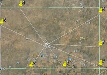
I will also post information about straight line landmarks and large triangular patterns. These things have been written about before so the information isn't new but, using google earth, you'll be able to see how and where the landmarks were setup along these lines. This in itself will prove valuable to those interested in historical research. You will be able to find when these landmarks were named and who named them.
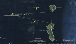
I'll start out with a couple of things that Steve has written in his posts and book. Steve has often expressed his opinion that some of the popular treasure stories were created to draw attention to a specific area. There is also a picture in his book on page 139 that shows a carved cross that points to the east at 85 deg. He also mentions a hole found on this bearing that was 4825 feet from the carving. Pull up your google earth and I'll show you a couple of things. First, here's a link that tells a treasure story about Captain Kidd. Olmsted and Captain Kidd's Treasure - Frederick Law Olmsted National Historic Site (U.S. National Park Service). According to the story the number 44106818 was used to find latitude and longitude to lead searchers to Deer Isle. The difference in the number in the story and the actual coordinates of Deer Isle were explained away as faulty calculations on Kidd's part. But, if you go to the latitude of 44 deg 10' and longitude of 68deg 18', you'll find yourself 15 miles east of Deer Isle. You will also find yourself a few miles west of two small islands, Little Duck Island and Great Duck Island. From the Kidd coordinates to the south shore of Little Duck Island it is about 2.73 miles and to the north shore of Great Duck Island it is about 2.71 miles. Also, the bearing from the Kidd coordinates to Little Duck Island is 85 deg. There is a treasure recovery story associated with Great Duck Island. https://en.wikipedia.org/wiki/Great_Duck_Island,_Maine.
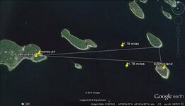
So what, you say, just a coincidence. OK, let's go a couple hundred miles east to Oak Island. Start your line at the Money Pit and go 85 deg for a distance of about 1.78 miles. You'll find yourself on the south shore of a small island that I don't know the name of. Just south of the island is another small island called Birch Island and it's about 1.76 miles from the Money Pit to the north shore of Birch Island. There is a story about a recovery of some type of important religious article from Birch Island. Here's the article. Articles_Oak | Andrew Gough.
So, we have two treasure stories two hundred miles apart that show similar elements that are not a part of the two legends. We have the bearing of 85 deg used at both sites leading to the south shore of the northernmost of two small islands and there are claims of a treasure recovery at both southern islands. From these two stories and Steve's observations, it's possible that the bearing of 85 deg could be important. I think this also proves the point about the treasure legends.
I've found, in the past, that there isn't much interest in this type of thing. We'll see how things go. I try to check Tnet everyday so please be patient if I don't answer a question right away. If anybody does have questions, most of my replies will be, "I don't know", that's because I don't have all the answers.


Amazon Forum Fav 👍
Last edited:


