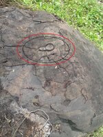
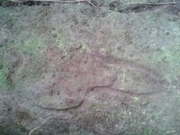
anyone have some experience reading signs in Mindanao thanks
Navigation
Install the app
How to install the app on iOS
Follow along with the video below to see how to install our site as a web app on your home screen.
Note: This feature may not be available in some browsers.
More options
You are using an out of date browser. It may not display this or other websites correctly.
You should upgrade or use an alternative browser.
You should upgrade or use an alternative browser.
philippine treasure signs....mindanao
- Thread starter goldcarl
- Start date
rangler
Bronze Member
- Jul 12, 2004
- 1,320
- 201
- Detector(s) used
- for solutions to the jesuit code -email pics to: [email protected]
;[email protected] locations needed! oro bro!
- Primary Interest:
- Other
kumustaka Goldcarl
welcome to net, post some pics of your finds and we will do our best to help you with them..
Yamashi.ta signs are taken off the spanish code changed just a bit to suit their culture.
but a very strong influence of Jesuit/Spanish code is evident. Some are direct copies, others are wholly Japanese, even using ancient Script of Kanga. We have some of them figured out...
salamat
rangler
rangler
Bronze Member
- Jul 12, 2004
- 1,320
- 201
- Detector(s) used
- for solutions to the jesuit code -email pics to: [email protected]
;[email protected] locations needed! oro bro!
- Primary Interest:
- Other
sam,
the pic is too close..I do see what looks like a drill hole, dsty has posted the best know decoding of the drill holes used by the spanish and others..check his posts...in the meantime a shot of the rock at a farther distance is in order...we need to see the sign in context..with each other, what else is around besides the drill hole..
salamat pinoy
rangler

long may it wave, over the greatest country
on Gods green earth...
memorial day 2011.
the pic is too close..I do see what looks like a drill hole, dsty has posted the best know decoding of the drill holes used by the spanish and others..check his posts...in the meantime a shot of the rock at a farther distance is in order...we need to see the sign in context..with each other, what else is around besides the drill hole..
salamat pinoy
rangler

long may it wave, over the greatest country
on Gods green earth...
memorial day 2011.
rangler
Bronze Member
- Jul 12, 2004
- 1,320
- 201
- Detector(s) used
- for solutions to the jesuit code -email pics to: [email protected]
;[email protected] locations needed! oro bro!
- Primary Interest:
- Other
Sam,
the ability to decode symbols depends on good photos...very anxious to see what you have found, but the photo is not so good..infact sorry to say manung, useless..
as always photo at the optimum time ie, 10 am until 1pm with the sun to your back if possible...then we can help
salamat
rangler
the ability to decode symbols depends on good photos...very anxious to see what you have found, but the photo is not so good..infact sorry to say manung, useless..
as always photo at the optimum time ie, 10 am until 1pm with the sun to your back if possible...then we can help
salamat
rangler
takara13103
Greenie
- Nov 4, 2004
- 18
- 0
- Primary Interest:
- Cache Hunting
Sam, by all means, break your rock! You ( and us readers) will surely gain something from your experience. If your rock turns out something, well ...... The drill hole there seems to tell us that you are on the spot of the treasure. Please document your efforts and share us your experience. May we hear from you.
dsty
Bronze Member
PLEASE DON'T, break your rock, your drill hole has a lot of information on it, photo the entire rock sometimes theres a feature in the shape of it, it seems to be on an angle, if it is then its a mooring hole and should be in the shape of transmission funnel, big at the top and small at the bottom or have a concave bottom. If it looks to the side then it has been my experience that a drill hole that big will send you away to look somewhere else, just stay with the trail, just look at the shape of the rock to see if it matches the surrounding terrain, there will be other things in the area to indicate the direction, if not then stay on the trail that got you there. Should be something else within a couple hundred feet.
Shortstack
Silver Member
- Jan 22, 2007
- 4,305
- 419
- Detector(s) used
- Tesoro Bandido II and DeLeon. also a Detector Pro Headhunter Diver, and a Garrett BFO called The Hunter & a Garrett Ace 250.
- Primary Interest:
- All Treasure Hunting
Sam:
NOBODY with good intentions would ever tell you to break that rock.
NOBODY with good intentions would ever tell you to break that rock.
tesoro dog
Sr. Member
- May 31, 2007
- 301
- 34
I believe takara was referring to breaking the code on the rock, and not literally " breaking the rock ". td
takara13103
Greenie
- Nov 4, 2004
- 18
- 0
- Primary Interest:
- Cache Hunting
Well, I literally meant to break the rock. Pulverize if need be. The drill hole there means end of the treasure trail.
Old Dog
Gold Member
A good treasure hunter will never destroy a sign.
That drill hole is never the end of a trail, only directions to the next sign.
If this is the way you read signs it's not a wonder why you don't find anything.
That drill hole is never the end of a trail, only directions to the next sign.
If this is the way you read signs it's not a wonder why you don't find anything.
rangler
Bronze Member
- Jul 12, 2004
- 1,320
- 201
- Detector(s) used
- for solutions to the jesuit code -email pics to: [email protected]
;[email protected] locations needed! oro bro!
- Primary Interest:
- Other
thom,
correct sir, never ever., what his guy is referring to - incorrectly - was the habit of the japanese hide everything from jewels to gold bars in side cement containers, not natural rocks, but the incorrect rumor swept all over the islands in the republic of the philippines.
these refrigerator sized concrete vaults have been found on beaches, and rivers all over the islands.
looking forward to better pics Carl
rangler
takara13103
Greenie
- Nov 4, 2004
- 18
- 0
- Primary Interest:
- Cache Hunting
The way I see it, it's the end of the trail. The signs are just in front of you.
dsty
Bronze Member
If you have a burning desire to know whats inside the rock a metal detector will answer your question. More photos of the entire rock and a good photo of the bottom of the drill hole will answer some questions also. Thanks
Mighty
Jr. Member
- Oct 30, 2013
- 48
- 9
- Detector(s) used
- Garrett GTI 2500 Pro Metal Detector with Treasure Hound Eagle Eye Depth Multiplier and Garrett Pro Pointer
- Primary Interest:
- All Treasure Hunting
erictreasure
Greenie
- Dec 19, 2013
- 12
- 1
- Primary Interest:
- All Treasure Hunting
I have a site here in the Visayan region and we have some positive signs engraved in the rock namely ( a heart shape, an F and an arrow). Our site also has a Japanese history. A lot of treasure hunters(korean and japanese) have been visiting our lot before and were very interested. Some of the koreans dug up some bones and brought it to korea. It is in the mountains and is near a river creek. A bomb was also found beside our lot and the bomb( water barrel size) was pointing to our lot. I would want to now if you have gadgets or a scanner that would be able to see the object and its depth. If possible, may I ask for your contact number. I am willing to negotiate it with you. Thank you very much. Happy Holidays and God bless you all.
dsty
Bronze Member
If you want to do something productive get the depth CM please , Width CM please , circumforence around the top of the hole CM please , then I can tell more about the direction and distance you need to go for better results. It is my opinion that the Vikings may have been the 1st to use drill holes, they used them to follow trails, distance, and several different uses as the trail , situtation called for. It would break my heart for someone to destroy something that had been there for hundreds of years.
Last edited:
Top Member Reactions
-
 3556
3556 -
 1972
1972 -
 1820
1820 -
 1201
1201 -
 1136
1136 -
 1011
1011 -
 883
883 -
 855
855 -
 817
817 -
 795
795 -
 742
742 -
 666
666 -
 577
577 -
 566
566 -
 502
502 -
 467
467 -
 422
422 -
E
416
-
 405
405 -
 399
399
Users who are viewing this thread
Total: 2 (members: 0, guests: 2)


