Lost Adams Diggings Found!

sdcfia,
I must disagree. Of all canyons that produced a significant amount of gold, this canyon is the closest to the Arizona border. The mining belt drifts in a north-east path, leaving this area the closest.

As far as the canyon being "Sno-ta-hay", it wasn't. Remember, the men never made it to "Sno-ta-hay". The guide pointed out two peaks a days ride away to the north-east and said that is the canyon he is taking them to. However, we will stay here tonight. However, since the men found gold in this canyon, they never made it to "Sno-ta-hay".

The guide told them that the nuggets at "Sno-ta-hay" were the size of hens eggs. My friend and the company he worked for, found nuggets the size of pocket watches in the "Sno-ta-hay" canyon.

Another little bit of history:
As we know, Jacob Snively left the canyon early, with his gold, because he was afraid of the apaches. Smart guy. He went back towards Tucson and sold his gold. Then he ventured down to where the Gila River meets the Colorado and started a gold rush there. Was actually made mayor for a little over a year, then talked two other men into following him back to New Mexico.

When they arrived at "Sno-ta-hay" they discovered the placer gold and went down to La Mesa to strike their claims. This started the gold rush at Pinos Altos. How did Snively know where "Sno-ta-hay" was? The guide showed them several years earlier.

Everything fits except the dates that all of the books say it happened in. It was not the late 60's, but the late 50's. Snively started the gold rush in Arizona in 58, traveled back to New Mexico and struck his claim for Snively Gold Works in 62.

As you know rooster, there are many versions of the LAD tale - often conflicting in many ways, including those allegedly from Adams himself, who may or may not have even been there. From your posts, it seems like you might be describing Apache Box, below Pine Cienega, as the site (photo below). Or, maybe you're referring to another place. If you post the coordinates, we can look into it, but otherwise it's just another claim that has to be taken at face value. Many folks claim to have located the canyon, but none of those places, including Apache Box, have any indications of significant free gold ever having been present.

I have no response to your pal's supposed results in the 80s - it's just another story. I do accept what you say about your own recoveries, but recreational placer guys, on good days, frequently bring home small amounts of placer. I live in Pinos Altos and I can walk over to my neighbor's place and pan fine gold out of the creek that runs through his property, but it's too much work to make it pay. There are lots of places like that.
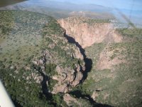
Apache Box 1.jpg
Apache Box
 

Last edited:
sdcfia,
That I will agree with you on. There are many different tales all called the Lost Adams. Personally, I believe there are many stories from the 1800's that were put together, or called the very same tale by James McKenna when he was writing his books. I, personally purchased several books by varying authors that all claimed the canyon was up north since Adams continually came back to the San Fransisco valley to look for the canyon.

However, there was one chapter... chapter 1 of Jack Percell's book that stood out. Out of all of the books, this chapter seemed like it didn't fit. I must have re-read that chapter over 100 times in the 6 years I hunted for this canyon. Traveled to many canyons during that time and put boots to the ground. Even found many landmarks from the stories, however... no gold.

In that chapter, Adams told R.C. Patterson, when he asked Adams what mountain ranges the guide took them into on the way to the canyon, that they never entered any mountain range until they were at the canyon. He said that there was vast plains on the left and small mountain ranges on the right the entire trip. I struggled with this for quite awhile, having made the trip from either Tucson or Phoenix to New Mexico a thousand times. That description of topology didn't match.

Then I thought, what if either Adams told Patterson the opposite, or Patterson remembered it being opposite, what would that give me. So I flipped the description to being vast plains on the right and small mountain ranges on the left and I realized it described the topology from Tucson to Lordsburg, New Mexico.

Then I remember from one of the many tales that Adams claimed that they traveled up a long incline on the way to the canyon. So I google earthed and found that the incline from Lordsburg into the Burro Mountains is 15 miles long. I would call that a long incline. If that is the way they traveled, they would eventually cross the Continental Divide. Another connection to the story.

Another part of the story Adams told Patterson was that they entered the canyon from the East side through the pines. I couldn't figure out why they would enter the canyon from the east side if they were traveling from the west to the east. Then I remembered, from another tale, that the guide took the men on top of a tall mountain to show them where the canyon was he was taking them to. Another part of an Adams tale, was that Adams believed at one point the guide left the well traveled trail and headed due north.

I started putting things together and realized that after they crossed the Continental Divide, the guide left the well traveled trail, "Mormons Wagon Trail" and headed due north up to the top of Jacks Peak. From there he showed them two peaks, north-east, a days ride away to where the canyon "Sno-ta-hay" was located, but they would stay the night in this canyon. Being that they were on top of Jacks Peak meant they traveled down into the canyon, through the pines.

This now, all made sense. "Sno-ta-hay" is Bear Creek, and Adams canyon is Gold Gulch. Gold Gulch, being 15 miles from the Arizona border, has been mined heavily in the late 1890's, 1930's and then more recently in the late 70's, early 80's. Finding a significant amount of gold. Thompson canyon, was also a popular route the Apaches would take when traveling back and forth to Mexico, would at some time find the men in the canyon.

Granted, you can't really call the two small objects a real waterfall, but we don't know if that is part of the real Adams story, or some other tale from the 1800's. The only part that bugged me about all of this is, based on the dates all of the books placed this at, why they would travel for four days to the fort and four days back to get supplies. Why didn't they just travel for a day into Silver City and get their supplies. That's when I decided the dates had to be wrong.

So I went back to the very first story I ever heard of the Adams Canyon and remembered that Adams met up with the other guys who had just returned from failing at the California Gold Rush. After a little research, I found that the Gold Rush lasted from 1848 - 1855. Now it all made sense. The dates were wrong. The time the men were in the canyon was in the late 50's rather than the late 60's. They had to travel so far because Silver City didn't exist at that time.

To back this up, I started doing research on Jacob Snively and found that he found gold in Arizona, on the Gila River and started a gold rush there in 1858. Spent a couple of years there and was actually the mayor for a couple of years. Then he convinced two other individuals to travel back to New Mexico where they found the gold placers of Bear Creek and staked their claim in La Mesa. By the time they got back up to Bear Creek and started their mining operations, tons of miners started showing up and here begins the gold rush of Pinos Altos.

Again, the only reason Jacob Snively knew where to take his two friends, was because he remembered what the guide showed them on the first journey into the canyon. The zig zag canyon is the little canyon that passes through the mountains from McCauleys head quarters into the valley between Lordsburg and Duncan. I believe Adams and Davidson traveled through that canyon when escaping the Apaches, found the Coronado Trail and headed north where the solders found them up around the Springerville area.

That is why Adams, in the later years, always started up there in his searches. He was trying to retrace his footsteps. However, being so terrified of the Apaches and only traveling at night, and when they were found by the solders almost dies of exposure, he most likely couldn't remember how far they traveled north before the solders found them.

The company my friend worked for, in the 80's was "Bear Creek Mining Corporation". They dredged Bear Creek from where Cherry Creek and Bear Creek meet, down towards Gila. Again, after rolling big boulders out of the way, found gold nuggets the size of a pocket watch.
 

Not to derail the discussion but I do have a question. I know that a lot of guys believe Jacob Snively was with Adams and thus is a part of the story. But I have never seen anything to positively link Snively with Adams. Adams party was hardly the only party of Americans poking around in the territory hunting for gold, and there are newspaper accounts of friendly Apaches even leading the Americans to gold. Does anyone here have anything that would prove Snively was with Adams? Thank you in advance, and please do continue.

:coffee2: :coffee: :coffee2: :coffee2:
 

sdcfia,
That I will agree with you on. There are many different tales all called the Lost Adams. Personally, I believe there are many stories from the 1800's that were put together, or called the very same tale by James McKenna when he was writing his books. I, personally purchased several books by varying authors that all claimed the canyon was up north since Adams continually came back to the San Fransisco valley to look for the canyon.

However, there was one chapter... chapter 1 of Jack Percell's book that stood out. Out of all of the books, this chapter seemed like it didn't fit. I must have re-read that chapter over 100 times in the 6 years I hunted for this canyon. Traveled to many canyons during that time and put boots to the ground. Even found many landmarks from the stories, however... no gold.

In that chapter, Adams told R.C. Patterson, when he asked Adams what mountain ranges the guide took them into on the way to the canyon, that they never entered any mountain range until they were at the canyon. He said that there was vast plains on the left and small mountain ranges on the right the entire trip. I struggled with this for quite awhile, having made the trip from either Tucson or Phoenix to New Mexico a thousand times. That description of topology didn't match.

Then I thought, what if either Adams told Patterson the opposite, or Patterson remembered it being opposite, what would that give me. So I flipped the description to being vast plains on the right and small mountain ranges on the left and I realized it described the topology from Tucson to Lordsburg, New Mexico.

Then I remember from one of the many tales that Adams claimed that they traveled up a long incline on the way to the canyon. So I google earthed and found that the incline from Lordsburg into the Burro Mountains is 15 miles long. I would call that a long incline. If that is the way they traveled, they would eventually cross the Continental Divide. Another connection to the story.

Another part of the story Adams told Patterson was that they entered the canyon from the East side through the pines. I couldn't figure out why they would enter the canyon from the east side if they were traveling from the west to the east. Then I remembered, from another tale, that the guide took the men on top of a tall mountain to show them where the canyon was he was taking them to. Another part of an Adams tale, was that Adams believed at one point the guide left the well traveled trail and headed due north.

I started putting things together and realized that after they crossed the Continental Divide, the guide left the well traveled trail, "Mormons Wagon Trail" and headed due north up to the top of Jacks Peak. From there he showed them two peaks, north-east, a days ride away to where the canyon "Sno-ta-hay" was located, but they would stay the night in this canyon. Being that they were on top of Jacks Peak meant they traveled down into the canyon, through the pines.

This now, all made sense. "Sno-ta-hay" is Bear Creek, and Adams canyon is Gold Gulch. Gold Gulch, being 15 miles from the Arizona border, has been mined heavily in the late 1890's, 1930's and then more recently in the late 70's, early 80's. Finding a significant amount of gold. Thompson canyon, was also a popular route the Apaches would take when traveling back and forth to Mexico, would at some time find the men in the canyon.

Granted, you can't really call the two small objects a real waterfall, but we don't know if that is part of the real Adams story, or some other tale from the 1800's. The only part that bugged me about all of this is, based on the dates all of the books placed this at, why they would travel for four days to the fort and four days back to get supplies. Why didn't they just travel for a day into Silver City and get their supplies. That's when I decided the dates had to be wrong.

So I went back to the very first story I ever heard of the Adams Canyon and remembered that Adams met up with the other guys who had just returned from failing at the California Gold Rush. After a little research, I found that the Gold Rush lasted from 1848 - 1855. Now it all made sense. The dates were wrong. The time the men were in the canyon was in the late 50's rather than the late 60's. They had to travel so far because Silver City didn't exist at that time.

To back this up, I started doing research on Jacob Snively and found that he found gold in Arizona, on the Gila River and started a gold rush there in 1858. Spent a couple of years there and was actually the mayor for a couple of years. Then he convinced two other individuals to travel back to New Mexico where they found the gold placers of Bear Creek and staked their claim in La Mesa. By the time they got back up to Bear Creek and started their mining operations, tons of miners started showing up and here begins the gold rush of Pinos Altos.

Again, the only reason Jacob Snively knew where to take his two friends, was because he remembered what the guide showed them on the first journey into the canyon. The zig zag canyon is the little canyon that passes through the mountains from McCauleys head quarters into the valley between Lordsburg and Duncan. I believe Adams and Davidson traveled through that canyon when escaping the Apaches, found the Coronado Trail and headed north where the solders found them up around the Springerville area.

That is why Adams, in the later years, always started up there in his searches. He was trying to retrace his footsteps. However, being so terrified of the Apaches and only traveling at night, and when they were found by the solders almost dies of exposure, he most likely couldn't remember how far they traveled north before the solders found them.

The company my friend worked for, in the 80's was "Bear Creek Mining Corporation". They dredged Bear Creek from where Cherry Creek and Bear Creek meet, down towards Gila. Again, after rolling big boulders out of the way, found gold nuggets the size of a pocket watch.

Very good work, rooster. You are 90% of the way there, IMO. Bear Creek is indeed the answer, IMO. If you pm me your email address, I'll send you my analysis to look at. By the way, do you mind mentioning the name of your buddy who was doing the work in the 80s? I might know him.
 

Not to derail the discussion but I do have a question. I know that a lot of guys believe Jacob Snively was with Adams and thus is a part of the story. But I have never seen anything to positively link Snively with Adams. Adams party was hardly the only party of Americans poking around in the territory hunting for gold, and there are newspaper accounts of friendly Apaches even leading the Americans to gold. Does anyone here have anything that would prove Snively was with Adams? Thank you in advance, and please do continue.

:coffee2: :coffee: :coffee2: :coffee2:

Probably the closest we have is the Jason Baxter account, in which Baxter calls the placer deposit the "Snively Diggings". This is based on an encounter Baxter describes in which he and two others met Snively in Pinos Altos in 1863. Snively was reportedly carrying $10,000 in placer gold (30 pounds!) from a rich deposit that he had just left because of Apache trouble. Baxter was a well-respected frontiersman of the day whose integrity was apparently unchallenged. It's all in Black Range Tales, written by another solid participant of the times, James McKenna.

Adams is another issue. We don't even know his full name. I suspect that if the man who later showed up with Shaw and told the stories was the true Adams and not an imposter, he was just another member of the ill-fated party that was attacked by Apaches - certainly not the leader. His tellings of the events are all over the map and the many discrepancies from one version to the next show that he was not a credible witness. Too many different stories. Maybe as he claimed, he was so traumatized by the attack that he forgot where he was and how he got there.
 

Oroblanco, unfortunately there isn't a manifest of who was part of the party. I wish there were, it would make the detective work a lot easier. There has to be something in the very beginning stories that somehow linked him with the party, and it carried through the other versions. Or it could be that he had nothing to do with the Adams party and the fact that he and his two friends ended up at Bear Creek to find the placers could just be mere coincidence.

Unfortunately, it is going to have to take finding other evidence that separates him from the Adams party to remove him from the tale.
 

Thank you for your replies. There are two Adams that certainly can 'fill the bill' for the two oldest versions of the tale, the second and later Adams tale is linked to Henry Adams, a man whom had some kind of trading post (possibly not legally) on or near the Navajo reservation. This Adams is the one whom was showing gold "nuggets" in Ft Wngate, which were actually just rich ore chunks not nuggets, and as you know Wingate did not exist in the 1850s when the original Adams story occurred.

I fear that the Jacob Snively stories have been linked to the Adams saga well after the fact, and in part by assumptions. That assumption being that since Snively was known to have found and recovered placer gold, enough to have some 30 pounds of it (I would be pretty happy with that!) and other similarities led them to assume that Snively was in the Adams party. The fact that Snively was killed near White Picacho by Apaches while prospecting toward Wickenburg would suggest that he had no knowledge of the location of the Adams 'mine' or why would he bother going toward Wickenburg rather than return to the zig-zag canyon full of gold?

Anyway thanks for your replies, please do continue.
:coffee2: :coffee: :coffee2: :coffee2:

Snively was killed in 1871. Here, in a radically truncated summary of events, is an answer to your question:

Snively "discovered" the Bear Creek placers in 1860, although the deposits had been worked by Anglos for at least ten years previously and also by the Chihene Apache before that. Bear Creek quickly became overrun by a rush of prospectors, but the camp immediately came under siege from the Mangus Coloradas band, culminating in the Battle of Pinos Altos in 1861, after which Bear Creek and Pinos Altos were abandoned. After Fort West was established in 1863 near the mouth of Bear Creek on the Gila River, Snively led the Stevens Party back to the diggings. Much gold was recovered, but then the massacre occurred, wiping out all of the miners except four survivors, including Snively, who sensed the danger and left early, returning to Arizona. Pinos Altos was resettled ca 1867 as the Apache problems were mostly abated by then. Bear Creek was flocked to again by prospectors. Snively didn't return to Bear Creek after 1867 for one obvious reason: the diggings were covered by working miners who had legal claims.
 

I thought the LAD was found in 1988 by Paul A. Hale and Chester Moeller as described in Dick French's book "Return to the Lost Adams Diggings". It's at +34.369528 -107.644132.
 

I thought the LAD was found in 1988 by Paul A. Hale and Chester Moeller as described in Dick French's book "Return to the Lost Adams Diggings". It's at +34.369528 -107.644132.
Those pesky diggings really get around. Here's a map showing many of the proven places they've been found. Hale's is the fourth red dot down from the top. Unfortunately, none of these sites show evidence of significant gold, currently or historically. Good book fodder though.
locations.jpg
 

I don't see how people who locate it elsewhere get around the fact that the party crossed a "well used trail" and then went another 10 miles. Later, the resupply party went back to that trail and went on it to Fort Wingate. Also, Adams told the marshal of Magdalena that the treasure was in the Datil Mountains and the marshal, Robert Lewis, and his search partner, Pettibone, went looking for it and a stone cabin with their papers in it was found about 10 miles south of the site I gave the coordinates for. Those facts, alone, make all the other dots on that maps clearly not correct.

But, I admit, although there's gold in the Datil Mountains and the extension of it on the other side of the Fort Wingate - Fort Craig trail, there's no lying-on-the-ground gold that has been found.
 

Last edited:
I don't see how people who locate it elsewhere get around the fact that the party crossed a "well used trail" and then went another 10 miles. Later, the resupply party went back to that trail and went on it to Fort Wingate. Also, Adams told the marshal of Magdalena that the treasure was in the Datil Mountains and the marshal, Robert Lewis, and his search partner, Pettibone, went looking for it and a stone cabin with their papers in it was found about 10 miles south of the site I gave the coordinates for. Those facts, alone, make all the other dots on that maps clearly not correct.

But, I admit, although there's gold in the Datil Mountains and the extension of it on the other side of the Fort Wingate - Fort Craig trail, there's no lying-on-the-ground gold that has been found.
When you look deeper into this legend, you soon realize two things:
1) There are many different tellings of the story, and most differ significantly with the others on many details. I have 20 or more "major versions", some merely parroting others' stories of course, but about 15 or so that you might call "source documents", i.e. written by searchers who were either contemporary with the Adams/Shaw post-LAD years or the generation that followed them into the early 1900s. In addition, another 30 or 40 newspaper articles from ca 1890-1940 provide information about new expeditions, where the searchers would be looking and why.
2) Adams himself may or may not have actually been a member of the miners' party, even though his name became permanently attached to it. If you give him the benefit of the doubt and assume that he was present, then he must be considered a highly unreliable witness, based on his testimony. He said different things to different people at different times and places. Perhaps he suffered from PTSD. The amount of conflicting material is very confusing.

Most LAD researchers tend to pick a favorite telling or two and draw their conclusions by cherry-picking select details that match clues they may have found and which they made fit their theory. If you pick the correct ("true") version, you're ahead of the game. Problem is, there might not be a correct published version to use.

When I first became interested in the LAD, I relied on the lengthy Byerts 1935 El Paso Times feature article, along with the Dobie and McKenna books from the 1930s. They all assumed that Fort Wingate was the supply fort, and not knowing much about the legend then, so did I. When I decided for myself that Fort West was more likely the supply depot, then many things began to make more sense. Some more ideas to ponder: the Gila River Trail east of the Pima Villages; the Santa Lucia Springs oasis; Twin Sisters Peaks; Mangas Coloradas and the Chihene Apache; Jacob Snively; and of course, where could rich placer gold be found in the 1860s in New Mexico?
 

This is a very reasonable post and I'll dig into some of the things you said. I guess another way to approach the location would be to try to find out if any large, on the surface, findings of gold nuggets have been found since 1864. Of course, if so, they may never have been reported.
 

It's interesting there is nothing there now, maybe because it appears to have been a Buffalo Soldier's camp. I just read that 1935 article that people reference and it says that Adams said the party crossed the continental divide, which would rule out most places. But it might be easy to be mistaken about something like that back in those days. That article pointed at the Zuni Mountains and the Malpais lava fields south of it. But looking on Google Maps, there are no really mountainous areas in either of those places, and Adams said the area got very mountainous. I'm beginning to believe the whole thing was made up by Adams.
 

It's interesting there is nothing there now, maybe because it appears to have been a Buffalo Soldier's camp. I just read that 1935 article that people reference and it says that Adams said the party crossed the continental divide, which would rule out most places. But it might be easy to be mistaken about something like that back in those days. That article pointed at the Zuni Mountains and the Malpais lava fields south of it. But looking on Google Maps, there are no really mountainous areas in either of those places, and Adams said the area got very mountainous. I'm beginning to believe the whole thing was made up by Adams.

... I'm beginning to believe the whole thing was made up by Adams.
We know from numerous credible, verifiable historical figures that a man calling himself "Adams" told stories about the prospecting party and the massacre. We can't positively identify who this witness was, but we can report that the stories he told were wildly contradictory to each other. Liars can't seem to keep their stories straight. It's my opinion that "Adams" either:
1) Heard the tale from someone else, then later claimed he was a participant, making himself seem important to others. When he indeed became sought after as a witness, he had no truth to reveal and tried to wing it.
2) Was a participant but had nothing but a vague idea where they went, either because of his inattention and inexperience; or as he claimed, the massacre traumatized him to the point that "he forgot".

Either way, the results are obvious - the man called "Adams" was not a credible witness. It's my opinion that there was a prospecting party that exploited rich placer deposits in the early 1860s - the abandoned and dangerous Bear Creek diggings, a war zone since 1861. There was a massacre with a few survivors - in 1863 by the Chihene Apache, following the murder of their leader Mangas Coloradas
 

Last edited:
Any of ya'll come across this post by a B.R. Atkins? This individual also made a comment on a LAD YouTube video. I have copied and pasted the comment in the YouTube video below this image.

1678460823843.png


B. R. Atkins
The lost Adams and the mine are on the Navajo Indian Reservation.i wrote a booklet in 1998 on it.the rich mine is less than a mile from the sonsella buttes on the reservation.the placer gold lies at elephant grass springs in a canyon .the indians that own the canyon floor have it fenced off. I notice they have rich houses and new cars who live above the canyon.the Navajo nation would not offer me i dime if i found it. Fluted rock is the large square Rock mentioned in the story.Sonsela buttes are the two twin peaks 18 miles Ne of fluted Rock.

Here is the YT video where he made the comment: www.youtube.com/watch?v=LCLhBn4qsH4
 

Don'cha just love "reality TV"-type stuff? Shhh ... wait a minute ... did you hear that? I think it's Bigfoot gonna steal our LAD gold! Oh, well, let's move on to the next treasure.
 

Top Member Reactions

Users who are viewing this thread

Back
Top