JESSE CAPEN ; What lead him to his search area?

393stroker

Hero Member
Jun 27, 2012
515
811
HOUSTON
Detector(s) used
Garrett pro-something
Primary Interest:
All Treasure Hunting
Last edited:
Hello

From what I've read, I believe "The Sterling Legend" was a big influence for Jesse. In her book, Estée seems to be a big fan of Tortilla Mnt. She's not alone in her beliefs. Many Dutch Hunters have favored this mountain as the one that holds the "key" to the Lost Dutchman Mine. Having walked all around this mountain, I have seen first hand the "draw" that this Mnt has on people. Even Jim Hatt was fond of this particular place.

Thanks
Travis
 

In the Corbin Ortiz letter it says the word( Tortilla MT, Tortila MT, or Tordia MT).
Depending on how you think the word is written.
I will get a cropped pic of it and put it on here.
Or just google Corbin Ortiz letter.
 

Chuck,

I believe Jesse met someone, and they may have influenced his decision on where to go in the range. Others probably have more information on this than I do. Maybe they will chime in here.

Take care,

Joe
 

I think that Jesse was more capable than we give him credit for, he had a good plan by setting up a base camp that he could work from for a few days. And it seems that he did a lot of research and planning. He just ran into bad luck before he could even get started. The first thing that comes to mind is people saying, Don`t go by yourself, Don`t go alone, which is good advice. I`ve been there, trying to get friends and family, and even trying to recruit people from the internet to join me. In the end I threw caution to the wind and went by myself. I knew of the the dangers and calculated the risk. In the end it made me a better person, and a lucky fool! I found some info on Peters Cave:Peter's Cave ? Canyoneering ? Arizona ? HikeArizona.COM
 

Last edited:
Very sad and eye opening on what a dangerous venture this truly is, even the most prepared can suffer from misfortune. Seems Tortilla Mountain is a favored location for the Dutchman mine depending on what information your using.

My family won't allow me to go into the Superstitions alone, it is difficult to find anybody willing to go and of course if they are a Treasure Hunter they have there own areas they would like to investigate. Of course we all know where we can find what we are looking for, just everybody has their own X location.
 

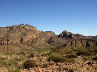
Tortilla Peak.jpg

Photo is of Tortilla mountain. The highest point is Tortilla Peak.
Take a point in the photo at the exact center of the photo and follow it to the skyline where the mountain and sky meet (the center of the photo ). Those are the cliff's where Jesse Capen fell. For those who have been on Tortilla mountain, to the peak and the mountain to the south and west, you know you cannot get to where Jesse had his camp by following the route Jesse took. Jesse took a direct line from the top of Tortilla Peak to his camp below along the Peters trail.

From above it appears as if you can just follow the mountain down by going that way. But after a ways you begin to run into cliffs and have to begin threading your way down. Finally you come to the point where you realize getting down that way is impossible without ropes and climbing gear. You reach sheer cliffs you did not realize were there when you started out. There is a point where you have to turn to the east and skirt around a part of the mountain and you will come out on the Peters trail. It is longer but is the only way to get to where Jesse was going that day. Jesse went west and and ran into the cliffs.

The day Jesse died was most probably December 5th. He had been to the top of Tortilla peak and left his name and date on a piece of paper in a jar with other hikers who had made the climb. His body was found below the Peak and on line with his camp. The 5th was a rainy overcast day with storms in the area. Darkness falls fast that time of year especially with overcast skies.

I believe Jesse was at the Peak and it started to get dark and a storm was brewing. Jesse made a bee line toward his camp, not realizing the cliffs he would run into. There is no trail the route Jesse took, he was going cross country over some rough ground. He either realized his mistake too late and tried to force his way down the cliffs, or more probably, it got dark and Jesse simply walked off the cliff without ever seeing them coming. That is an easy thing to do in those mountains when darkness and dusk falls. You are watching the horizon and the horizon is not the ground you are currently walking over. More than one has gone over a cliff not realizing it was there.

Jesse was a capable hiker and camper, well prepared, but that one day he made a mistake and it cost him his life. He fell about 75-100 feet and came to rest on a ledge about 25-30 feet off the ground. His pack went all the way to the bottom and was found laying in the brush below him. No one will ever know the exact circumstances but this appears to be what happened in his last hours. Jesse was not lost, he probably could see his camp below for much of the time he was descending the mountain before he reached the cliffs.

Matthew
 

Thanks for sharing that Matthew. I was wondering where it happened. When I went to Pinto Creek last March I climbed a hill to look on the other side to make sure I was in the right area, and I was running out of daylight. I had that sense of urgency to get back down before it got too dark because I didn`t want to be climbing around in the dark. That`s what probably happened to Jesse. Chuck
 

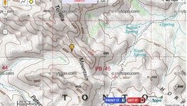
Jesse Capen location.jpg

On this map is the approximate location where Jesse Capens body was discovered. It is not exact but it is very close. The GPS location taken in the field does not correspond exactly with the topo map coordinates and the way the topo map is drawn.

Dirty Dutchman posted earlier about Jesse Capen's keen interest in Estee Conatser's book The Sterling Legend. Conatser relied heavily on the SW end of Tortilla mountain as being her focal point for the mine and treasure. Conatser used Mike Bilbry's Stone Crosses as PART of her research and theories.

The Stone Crosses were discovered within a short distance of where Jesse's body was discovered. Mike Bilbry had filed several mining claims on that SW corner of Tortilla mountain, seven of those claims were directly west and a little south of Jesse's location. One claim, the one Bilbry named LD8 was just north and a little east of the other seven. This #8 claim was as close to Jesse's location as the other seven were. Bilbry's claims and the location where he found the Stone Crosses are one and the same.

While I believe Jesse was trying to get back to his camp along the Peters trail when he fell, in the back of my mind I can't help thinking maybe, maybe he was trying to get down to where Bilbry discovered the Stone Crosses. Of course like Jesse's camp, he couldn't get down to where the Crosses were discovered because of the cliffs. I hate to think Jesse tried to scale down those cliffs with no equipment. They are treacherous as even if you can get down part way, you get trapped and can proceed no farther and getting back up can be impossible.

I still think Jesse was just trying to get to his camp as quickly as possible. The mystery and true circumstances may never be known.

Matthew
 

View attachment 853558

Photo is of Tortilla mountain. The highest point is Tortilla Peak.
Take a point in the photo at the exact center of the photo and follow it to the skyline where the mountain and sky meet (the center of the photo ). Those are the cliff's where Jesse Capen fell. For those who have been on Tortilla mountain, to the peak and the mountain to the south and west, you know you cannot get to where Jesse had his camp by following the route Jesse took. Jesse took a direct line from the top of Tortilla Peak to his camp below along the Peters trail.

From above it appears as if you can just follow the mountain down by going that way. But after a ways you begin to run into cliffs and have to begin threading your way down. Finally you come to the point where you realize getting down that way is impossible without ropes and climbing gear. You reach sheer cliffs you did not realize were there when you started out. There is a point where you have to turn to the east and skirt around a part of the mountain and you will come out on the Peters trail. It is longer but is the only way to get to where Jesse was going that day. Jesse went west and and ran into the cliffs.

The day Jesse died was most probably December 5th. He had been to the top of Tortilla peak and left his name and date on a piece of paper in a jar with other hikers who had made the climb. His body was found below the Peak and on line with his camp. The 5th was a rainy overcast day with storms in the area. Darkness falls fast that time of year especially with overcast skies.

I believe Jesse was at the Peak and it started to get dark and a storm was brewing. Jesse made a bee line toward his camp, not realizing the cliffs he would run into. There is no trail the route Jesse took, he was going cross country over some rough ground. He either realized his mistake too late and tried to force his way down the cliffs, or more probably, it got dark and Jesse simply walked off the cliff without ever seeing them coming. That is an easy thing to do in those mountains when darkness and dusk falls. You are watching the horizon and the horizon is not the ground you are currently walking over. More than one has gone over a cliff not realizing it was there.

Jesse was a capable hiker and camper, well prepared, but that one day he made a mistake and it cost him his life. He fell about 75-100 feet and came to rest on a ledge about 25-30 feet off the ground. His pack went all the way to the bottom and was found laying in the brush below him. No one will ever know the exact circumstances but this appears to be what happened in his last hours. Jesse was not lost, he probably could see his camp below for much of the time he was descending the mountain before he reached the cliffs.

Matthew

I'd say that's a pretty reasonable theory as to what happened to Jesse. For me personally it's another reminder to have things along in my backpack at all times in the event I had to spend at least one night alone in the mountains. I've been tempted on occasion to leave my main supplies and pack at a campsite and just toss on a light pack with only water, or worse yet just a bottle of water or something and just plan on making a "short exploration" of something I feel is close by.

I have an internal voice however which always kicks in at that moment and I either don't venture any further than I can physically see my campsite (which ain't far out there from what I've experienced), or I make sure I take along those necessities I mentioned earlier.

The thing is, I know myself - I know what my limitations are and what my personality is like. When I go exploring a "short distance away," I almost always see something just a "little further" to take a look at, or wonder what's over that ridge, or in that depression or crevice. Before I know it, I've lost track of time, lost track of looking around for landmarks to navigate by and can easily get in a situation where I'm a little lost and need time to get my bearings straight.

It can be a terribly unforgiving place to get lost and be unprepared in.
 

dangerous mountains paul...with or without gear.
I fell down an airshaft into a mine once...subsidence...the earth just moved...I was lucky to get away with a butt full of barrel cactus needles...long dark drop...

nice write up matthew...thanks
 

I do hope you now include a gun after your close call Cub.

I do Frank - I do! I'm very thankful that Arizona and New Hampshire have non-restrictive gun laws because it makes it very easy and convenient to travel with a handgun in checked baggage.

Have .357, will travel :)
 

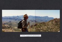
Clay Worst Superstitions 84.jpg

Cubfan,

Photo I took of Clay Worst many years ago on Tortilla mountain. We had been up Indian Springs canyon to Petrasch's camp in a little basin at the head of that canyon. From Petrasch's camp it's just a short walk straight west to the the cliffs on the west side of Tortilla mountain. Peters Mesa can be seen in the background to Clay's left, Tortilla Peak is just behind and to Clay's left. This is the best route to take for anyone trying to get to Tortilla Peak and most probably the same route Jesse Capen took the day he died.

Whenever Clay and I were out away from camp we always agreed on an emergency plan in case we hiked out too far or were working somewhere and it got too late to return to the base camp. We always knew of two or three places in the area with good natural shelter and would agreed on a rendezvous place in case we got seperated or were working two areas to cover more ground. We also had a signal system worked out in case we couldn't both make it to the rendezvous point or back to base camp. Carrying a little extra food and water for an emergency was a given and emergency items were always in our packs. It all had to do with planning things out before we left camp.
Both Clay and I have spent nights out away from the comfort and safety of camp and survived in relative good shape.

Clay always carries a sidearm when in the mountains. I always carried a .45 up until the time Crazy Jake went away and after that the need became less and less. A 30-30 Winchester and pistol are stashed out there close to one of our camps in case of an emergency.
Otherwise I haven't carried a sidearm for many years.

Matthew
 

I saw a bear out there my very first time. And even though he was running away, there's no way in heck I'm ever going out there without a pistol. I'm too chicken!
Waylon
 

in fifty plus years, i have never carried a firearm into the superstitions...well...i did carry that 303 all around superior area...

Pippinwhitepaws

I've always carried a firearm with me, Its a survival tool with a lot of uses beside the protection part, it can feed you, gun power can burn a wound shut if need be or signal some one if your in trouble ect. It should be the first thing to pack when your out hiking in the hills.

Never leave home without it!

Wrmickel1
 

Top Member Reactions

Users who are viewing this thread

Back
Top