Navigation
Install the app
How to install the app on iOS
Follow along with the video below to see how to install our site as a web app on your home screen.
Note: This feature may not be available in some browsers.
More options
You are using an out of date browser. It may not display this or other websites correctly.
You should upgrade or use an alternative browser.
You should upgrade or use an alternative browser.
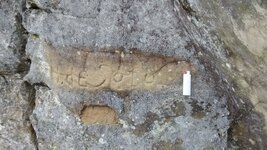
de Soto carving in Arkansas
- Thread starter Fox Hound
- Start date
weekender
Sr. Member
- Feb 28, 2009
- 497
- 1,161
- Detector(s) used
- Prism V
- Primary Interest:
- All Treasure Hunting
Nice !!
Have not seen this before.
Can you say where in Logan county?
Thanks,
-Weekender
Have not seen this before.
Can you say where in Logan county?
Thanks,
-Weekender
- Thread starter
- #5
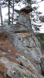
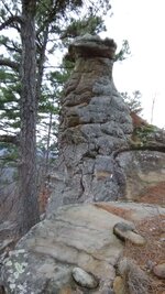
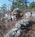
This is in the national forest. There is an overlook nearby that is listed on the forestry trail maps but I do not know if that makes it a park. This monument does have a close ATV trail and a slight foot path leading to it. Most do not know about this monument and say they have been near it but didn't know it was there. There are countless signs and symbols leading to it. It is looking west toward multiple face monuments along the ridge. I will post more pics when I can get to a better signal.
I'd like some feedback about this before I share the location.
I would suggest you show an archeologist or state historian before you make it public. They might be able to protect it, but it has been my experience that they will show no interest. If you make the location known to the general public, it won't be there for long.
- Thread starter
- #9
I have read some of the journals that are online. It states that he stopped at Morrison Bluff to help break up a steamboat gambling gang. There is a marker with his name on it that is believed by locals to be his tombstone about 1/2 mile south of the river in Morrison Bluff. I haven't seen it yet but hope to get permission soon. I have also read that he went to Hot Springs and Caddo Gap which is South of Morrison Bluff. This is beside the river bridge at Morrison Bluff 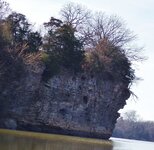

- Thread starter
- #11
I would suggest you show an archeologist or state historian before you make it public. They might be able to protect it, but it has been my experience that they will show no interest. If you make the location known to the general public, it won't be there for long.
Thank you! Have any of those names and numbers

Thank you! Have any of those names and numbers
Here are a couple of links that might help you.
https://archaeology.uiowa.edu/national-association-state-archaeologists-arkansas
About Us | Arkansas Historical Association
Good luck.
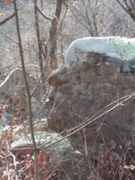
I walked it out (climbed and stumbled alot too) and found these on the west side of the bird monument. This is just a drop in the bucket... View attachment 1410215View attachment 1410217View attachment 1410218View attachment 1410219
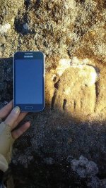
If that's a bear track carving, the bear track was a marker allegedly used by French miners on Treasure Mountain in Colorado. Here's a link describing markers used at the site but these letters don't give much information about the location described.
GET MCKENZIE!: The Treasure Mountain, the Beale Ciper and plagiarism
The Arkansas River was also a part of that legend.
maccounty
Full Member
- Jan 7, 2016
- 236
- 307
- Detector(s) used
- Garrett AT Pro Minelab go find 60 Garrett pin pointer
- Primary Interest:
- All Treasure Hunting
Awesome. If you're ever near caddo gap it's got a cool monument worth stopping and checking out. If I remember right it has a historical marker on the highway, just follow it. Gives a history of de Soto and a battle he had with the Indians there. I got pictures somewhere. I'll see if I can download them.
- Thread starter
- #16
Here are a couple of links that might help you.
https://archaeology.uiowa.edu/national-association-state-archaeologists-arkansas
About Us | Arkansas Historical Association
Good luck.
Thank you mdog. I did talk to the Mt. Magazine Forestry today. They will let me know Monday if this area has been surveyed, documented and protected. I was told that they don't normally make these areas known to the public to help keep vandalism down. This area has alot of briars, devil's walking sticks and thorn trees. The ATV trail that is nearby has several fallen trees that have blocked passage for awhile. I've had the feeling that the area was being blocked. I will contact both of the links you provided on Monday.
- Thread starter
- #17
If that's a bear track carving, the bear track was a marker allegedly used by French miners on Treasure Mountain in Colorado. Here's a link describing markers used at the site but these letters don't give much information about the location described.
GET MCKENZIE!: The Treasure Mountain, the Beale Ciper and plagiarism
The Arkansas River was also a part of that legend.
Thank you for the link! I will check it out after I finish replying to everyone : ) The front and back of the bird resemble the shape of the carving...
- Thread starter
- #18
Awesome. If you're ever near caddo gap it's got a cool monument worth stopping and checking out. If I remember right it has a historical marker on the highway, just follow it. Gives a history of de Soto and a battle he had with the Indians there. I got pictures somewhere. I'll see if I can download them.
I have been wondering if there were other monuments as cool as this bird and will check that out soon. I'd love to see your pictures!
- Thread starter
- #19
also curious if there was anything that sat on the top of this precipice that time an erosion may have brought down
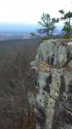
I am only 5'2" and could not see the top so I carefully stood on the back of the bird and tried to photograph the top. I had over 350 pictures to download from the latest visit and haven't finished looking at them all. There are a lot of rocks and thorns below the bird. I have tried to find the piece that is missing below the de Soto carving but have had no luck yet. I wonder if something was carved on it. There are other carvings on the bird. I'll share more pics when I can : )
dsty
Bronze Member
DSTY likes this
Top Member Reactions
-
 3556
3556 -
 1972
1972 -
 1820
1820 -
 1201
1201 -
 1136
1136 -
 1011
1011 -
 883
883 -
 855
855 -
 817
817 -
 795
795 -
 742
742 -
 666
666 -
 577
577 -
 566
566 -
 502
502 -
 467
467 -
 422
422 -
E
416
-
 405
405 -
 399
399
Users who are viewing this thread
Total: 2 (members: 0, guests: 2)
