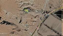
Curious what other dowsers get on 4 photos

Red_desert

Gold Member
Feb 21, 2008
7,016
3,656
Midwest USA
Detector(s) used
Garrett Ace 250/GTA 1,000; Fisher Gold Bug-2; Gemini-3; Unique Design L-Rods
Primary Interest:
All Treasure Hunting
All photos are next to each other.

photo-dowse_1.jpg


Top left and top right.

photo-dowse_2.jpg


A narrow ravine separates this archaeological site from the hill which has a few caves running through it.
 

Last edited:
Lower area photos, directly below the first ones.

photo-dowse_3.jpg
 

Do they have to dowse for the 4th photo?
 

I was trying to upload 4th.

photo-dowse_4.jpg


A professional treasure hunter once had permission from the government to search. Using a map etched in copper dated between more than 600 years old but probably close to 2,000 years as the language identified the culture. The map was found in one of these caves. It mentions another map which interprets the distance code. Nobody has ever seen the other map.

Google Earth map if you need it.

GE_map_QN_1.jpg


Government canceled treasure hunter's permits when he requested the permission to excavate.

GE-map_QN_1B.jpg


Gold and silver caches mentioned.

GE-map_001.jpg


A different perspective.

GE-map_003.jpg


New area zoomed in. This looks so familiar, I'm almost certain treasure hunters have given us dowsers it to dowse before (without telling us where). But only government archaeologists can excavate this site.

GE-map_006.jpg
 

Last edited:
You have a big target there
The orange rectangle mean treasure of gold and silver
The red line mean measure of deep
curios-3-red_desert.jpg

..aproximate its a 90 kg treasure, gold 30kg and 60kg silver

..probably ingot gold
 

Last edited:
The professional treasure hunter who had the permits believed his metal detector had found a silver cache and a big gold treasure. He tried burying a large amount of silver on his property. Checking signal strength with his metal detector, then checked the signal somewhere around this site. It was a close match but slightly stronger at the site. Checking the possible gold cache, metal detector signal strength was twice as strong to his buried silver at home. Copper map mentions silver and gold buried in different amounts.
 

Check for gold or silver religious artifacts also.
 

Divided that area into 4 sections, hopefully make pinpointing easier.

photo-dowse_3A.jpg


Top right...

photo-dowse_3B.jpg


Bottom left...

photo-dowse_3C.jpg


Bottom right...

photo-dowse_3D.jpg
 

I got the strong hit in top right section and other in both of the bottom.
 

In 3rd photo
curios-3z2-red_desert.jpg
 

Yes, a lot of interesting things here. There should be another copper map somewhere (one that gives distance code for gold and silver caches). More than 1,000 priests escaped through tunnels during the invasion of a city 18 miles away.

Top right corner area of 3rd photo is where my hits were also. Thought it be religious artifacts. Some of the silver treasure should be in the form of holy vessels. You might try the top left of section #4.

There is supposed to be a cave high up on a hill. A couple boys with metal detectors tried to make it up with a digging machine. If that was something like a small backhoe, would have been a slow hard climb up a narrow goat path. Government learned of their plans, waited at top of hill, then caught the boys attempting to search for treasure.
 

Last edited:
If there are jewels and church artifacts its hard to sell them but maybe you can creating a collection for sell in an auction
 

If there are jewels and church artifacts its hard to sell them but maybe you can creating a collection for sell in an auction


It is far more complicated than church jewels, is a national treasure. The copper map had a drawing of underground storage rooms at a site over 18 miles away. A network of tunnels reach for 18 miles between the caves and treasure rooms. I watched the video when government archaeologist made a tabletop model of the rooms from map drawings. They actually found a tunnel that went around underground storage. In video it showed hole in wall archaeologists made. Then government people went inside to look, came back out and sealed up the wall agian.
 

Red_desert, if still there the treasure, so, will be easy get the location with dowsing because have to be a huge target or multiple targets aside on aside
 

I think it is both huge targets and multiple.
 

I get multiple targets, 3 or 4 ..aside on aside
Tons of gold: 20, 60, 80, etc
And a huge cavity (green color)
 

Attachments

  • curios-GE-map_003.jpg
    curios-GE-map_003.jpg
    676.4 KB · Views: 19
Try checking from your circles moving toward the top right corner, but only part way. There is a spot I had marked 2 hits. It could be your location is a bit off. Yes, 2 good solid dowsing can be found this area.
 

The priests used tunnels and I'm thinking the area might be where the tunnels lead to.
 

Found my map with the 2 hits, there should be more.

hits_cave-map2.jpg


Actully, your map was zoomed in different than what I marked. Could be your hit is where the first large signal showed up.


curios-GE-map_003.jpg
 

Last edited:
red_desert:
Your 2 targets are buried not in a cavity
Your 2 targets are in different location, through the mountains/hills
Your 2 targets 1 target is tons of gold the other kilos

I dont doubt can be more huge targets near :occasion14:
 

Last edited:

Top Member Reactions

Users who are viewing this thread

Back
Top