Curious Questions Thread

Ironwill

Jr. Member
Jul 2, 2013
91
31
Primary Interest:
All Treasure Hunting
Okay I keep having more and more questions, so I thought I'd post them here, as well as give others a place to post all things Adams/Geological/gold searching related.

First one...
Lots.png

So from what I gather, this is some land owner dividing up a huge area into sublots for future community and such. Question....
If for any crazy reason someone thought the LAD was here (or wanted to gold prospect a canyon near it and unsure of boundaries), is it okay or illegal? Must be hard to find ownership information and claim information in a vast desert like this.
 

Those look like drill pads.

Prospecting or treasure hunting on private land without written permission will put you in the hoosegow (or worse in rural New Mexico).

Land Status and ownership is available to all on Land Matters for free. No excuses - do your research before putting boots on the ground.

Mining Claims and mineral ownership are also available for free. :thumbsup:
200w.gif


Thank you sir! :icon_thumright:
 

Yeah, private land. Judging by the geometry of the presumed new roads and cul-de-sacs, somebody is likely subdividing a parcel into multiple lots. If the subdivision has been approved by the county, you can get a plat and information on current lot owners from the assessor's office.

If your target is on an unsold lot, you might just walk the property as a prospective buyer to size up your ideas against what you see there. Contact the realtor for permission to explore. Nothing suspicious about that plan.

Remember -as Clay Diggins mentioned, property owners often don't take kindly to strangers on their land.
 

Okay guys...I'm freaking STUMPED!! WTF is this doing out there!??
WTF.png


A dirt road out in the middle of nowhere going to a 30 feet diameter satellite dish. the raised foundations around the outer edge that you can see by my yellow lines are 107 feet each leg.
The coordinates are 34.183287, -107.461561 Anyone have a guess? ???:dontknow:
 

HOLY CRAP! I know what that is! It's an underground bunker complex! See that rectangular box thingy near it? Look closely...one end is open! That's the stairs to go down in it. OMG what a find! :hello2:
 

Okay guys...I'm freaking STUMPED!! WTF is this doing out there!??
View attachment 2113988

A dirt road out in the middle of nowhere going to a 30 feet diameter satellite dish. the raised foundations around the outer edge that you can see by my yellow lines are 107 feet each leg.
The coordinates are 34.183287, -107.461561 Anyone have a guess? ???:dontknow:
It's a water tank in a sheep pen. There is a grain trough in the center and a salt lick in the corner.
 

It does appear to be a tank and a trough. Here''s the same location from directly overhead. The shadows are not consistent with a satellite dish or a stairway, but they are consistent with a tank and a trough. The "raised foundation" lines are more likely to be fence lines. But it does seem a strange place for it -- in the middle of a national forest with nothing around for miles in any direction.

Screenshot of Safari (11-7-23, 4-18-46 AM).png
 

It's a water tank in a sheep pen. There is a grain trough in the center and a salt lick in the corner.
Okay I did some more digging... here is a picture from 2013...
WTF2.png

this is clearly a satellite dish with a bunker entrance. There is no salt lick in the corner, as this photo shows that they were indeed fence posts. In this 2013 shot, you can see that its not a trough. One end is open ended with a 32 inch landing and line striations to suggest stair steps. The walls of "trough" are 6-8 inches thick. The black spot on the dish is the "feed horn" for it.

In the original picture I posted you can make out one of the arms for the feed horn, and also the entrance is "concrete gray". It is 4 feet wide by 8 feet long. That is a standard ground level stair entrance to an underground bunker. I spent an hour researching this stuff lol
 

Hard to say without being there, but if its a satellite dish and a bunker, it's missing several things I'd expect to see -- power lines, a road, and a substantial fence, for starters. It would also be odd for a satellite dish to point straight up, as this object appears to.
 

Hard to say without being there, but if its a satellite dish and a bunker, it's missing several things I'd expect to see -- power lines, a road, and a substantial fence, for starters. It would also be odd for a satellite dish to point straight up, as this object appears to.
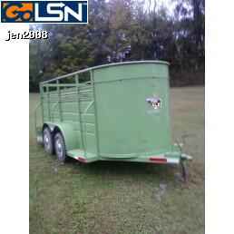
Green+topless+2.jpg


You know...this is 4 feet by 8 feet and alot of those horse trailers have 45 degree fronts instead of rounded. Seems 45 degrees like you see there in the map. Also the 6 to 8 inch thick waslls I see...MIGHT be those fender skirts. Hrmm like you said hard to say for sure. Either way its SOOoooo odd for that place (bunker or silo) to be out there in the middle of nowhere. Also...Its marked on my map...and in 2 years, when I get out there, I WILL BE CHECKING IT OUT! :D
 

Last edited:
Google makes no claims as to the accuracy of the coordinates in Google Earth. These are provided for entertainment only and should not be used for any navigational or other purpose requiring any accuracy whatsoever.

Our imagery varies from sub-meter resolution in major cities to 15 meter resolution for most of the earth's surface, with a global base resolution of 1KM. Since our database is constantly being updated, we cannot state a specific resolution for any geographic region.

Google acquires imagery from many different sources with many different file formats, projections and spectral characteristics. All imagery sources are fused into a single global database with a proprietary format that has been developed for the specific purpose of streaming to our client software.
 

Either way its SOOoooo odd for that place (bunker or silo) to be out there in the middle of nowhere.:D
Yes that would be beyond odd.

What does make sense is the Forest Service gives grazing permits for livestock on almost all forest lands. The BLM, Tribes and New Mexico State does the same for the lands they manage. All grazing allotments have water tanks, corrals and feeding stations.

In fact I have made a map of those grazing allotments which allows you to look up who has the grazing permit and what animals are grazing.
Ask the forest service about that allotment and they will tell you exactly how many sheep are grazing that allotment what times of year they are allowed on the allotment and how much water the water tank holds.

p.s. The Forest Service has no permits in New Mexico for Satellite dishes or buried bunkers but if such a thing ever was attempted you can bet the idiots that did it would be sitting in jail.
 

Another cool find... Some rock foundations of two homes
dwellings.png


Coordinates are... 34.709529, -107.703071
 

Anyone know what these are?
Weird Circles.png

They are scattered all over the place many coordinates...
34.440863, -107.501232
circles2.png

34.435691, -107.497581

Are they some kind of old pueblo yurt dwelling ruins?
 

Hey Pepper...so the pueblo indians made thos cisterns back in the day to catch water?
It wasn't rocket science for the different cultures around the world to build them to retain water for the dry spells.
It took water to survive and to grow a crop of some sorts.
Seen cisterns that dated back well over a 1000 yrs (India) still used today for the needs.
So why not in the dry NM territory as well.
I really believe that knowledge sharing was more than what academia states or believes to be factual.
 

Hydraulic.png
This is on the side of a Mesa...is this an example of past Hydraulic Mining? It doesn't look natural.
 

Top Member Reactions

Users who are viewing this thread

Back
Top