Creek walk today. Very little magic.

Blackfoot58

Silver Member
Jan 11, 2023
4,417
10,721
Iowa
Detector(s) used
Makro Simplex+
After a few hard rains, I ventured to the creek today. Stinging nettles 30” tall. New deposit of silt over rock bed at creek.😢 I got some great rock garden fodder. I had a few of those AHA! moments that ended up being Ah Shoot! moments instead.
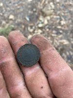
IMG_2999.jpeg

Not to be.
IMG_3001.jpeg

Ditto.
IMG_3003.jpeg

Bottom row: 2 non-points from in situ photos, another “sorry” and a chunk of chert that resembled a scraper, when under water.
IMG_2998.jpeg

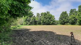
All of the sand you see, was recently dumped via flood. Previously that area had a lot of exposed stones. Thanks for looking.
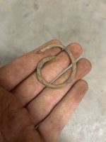
 

Upvote 10

tamrock

Gold Member
Jan 16, 2013
15,012
29,947
Colorado
Detector(s) used
Bounty Hunter Tracker IV
Primary Interest:
All Treasure Hunting
Does that creek intersect with another creek or river near by? If so that's where you want to look. It's those locations where streams, creeks and rivers meet the ancients identified as places to be at or go to. This is the map I believe the native peoples before us would know and understand other than they didn't use a drawn map. They just knew what was where in their minds. I found all these items at such a location within the busy front range Interstate 25 corridor of the Colorado front range plateau. It's a place were two tiny creeks meet that hasn't be scraped clean by a fleet of earth movers yet to make way for more developments. I've searched the creek beds, but so far found nothing outside of some interesting aluminum rocks.
 

Attachments

  • All-water-flows-river-map-of-the-USA-1.jpg
    All-water-flows-river-map-of-the-USA-1.jpg
    73.9 KB · Views: 5
  • IMG_20170906_121149 (1).jpg
    IMG_20170906_121149 (1).jpg
    1 MB · Views: 5
OP
OP
Blackfoot58

Blackfoot58

Silver Member
Jan 11, 2023
4,417
10,721
Iowa
Detector(s) used
Makro Simplex+
Does that creek intersect with another creek or river near by? If so that's where you want to look. It's those locations where streams, creeks and rivers meet the ancients identified as places to be at or go to. This is the map I believe the native peoples before us would know and understand other than they didn't use a drawn map. They just knew what was where in their minds. I found all these items at such a location within the busy front range Interstate 25 corridor of the Colorado front range plateau. It's a place were two tiny creeks meet that hasn't be scraped clean by a fleet of earth movers yet to make way for more developments. I've searched the creek beds, but so far found nothing outside of some interesting aluminum rocks.
No other creeks intersect it anywhere nearby. This creek eventually runs into the Iowa river. There’s a lot of private property between my section and the confluence.
 

Top Member Reactions

Users who are viewing this thread

Top