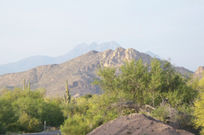
Clue 4 Peaks Lined up as 1

Apr 17, 2014
2,273
1,636
Sagittarius A*
Primary Interest:
Other
A) Is this clue supposedly valid?

B) I see around the old posts people show this way off course - too far west.

Here is where I think it lines up - way to the east. East of the magnetic anomaly even. The idea of being lined up with those 4 peaks and still 'north' of Weaver's needle doesn't seem to work. What am I missing?

Is it some other 4 peaks? Coordinates please :D
 

A: - the clue has about the same value as most of them, there is no absolute proof that Waltz ever said it, nor conclusive proof that he did not. It may have been one that is true and yet "fuzzy" enough that he felt no danger that others might find his mine by that information, like the part about the old Military Trail.

B: -the problem is that there are a number of locations where the four peaks of Four Peaks APPEAR to line up; in fact they never do line up and cannot, as you can see on a topo map they are not in a straight line. It is deceptive to look at this by satellite imagery, remember the men of Jacob Waltz's day could not even fly ten feet off the ground, landmarks visible from the ground are what they worked from not any birds-eye view. Anyway there are at least two spots to the SW of the peaks, a good sized area to the SE, an area to the NE in the Sierra Anchas etc where the peaks APPEAR to line up well even though in reality you are only able to see two or three of the peaks lining up, the other peaks are not visible due to elevations involved.

C - there is no other 4 Peaks in Arizona as far as I know, though there are several Sombrero Peak/Butte/Mountain-s in southern Arizona alone. Also there are several "pointed peaks" just in the Superstitions, which could be the pointed peak mentioned in clues, Waltz never stated it was specifically Weaver's Needle.

When/if you go to the area you will see how different things look from ground level, than from satellite views. The view from overhead distorts the impression, especially in how steep things are, but also trails can look like stream beds, boulders like bushes etc; the three Utah men were apparently deceived by a stream bed they took to be a trail, which must have been a very difficult hike for them, and they ended up dead. Don't depend on Google Earth to judge what that terrain is really like.

I hope this is of some help, good luck and good hunting amigo I hope you find the treasures that you seek.
Oroblanco
 

Could be the "clue" was only a reference to where First Water could be found, on the way into the mountains.
From the place where you leave the Apache Trail, turning onto the side road to First Water, this is what you see when looking towards Four Peaks.
The two may line up even better, the closer you get to First Water......Frog Peaks in front/Four Peaks in the distance.

four peaks X 2.png

Then again, maybe they meant "Frog Peaks" all along.

Regards:SH.
 

Last edited:
A) Is this clue supposedly valid?

B) I see around the old posts people show this way off course - too far west.

Here is where I think it lines up - way to the east. East of the magnetic anomaly even. The idea of being lined up with those 4 peaks and still 'north' of Weaver's needle doesn't seem to work. What am I missing?

Is it some other 4 peaks? Coordinates please :D
If you try to line up the Four peaks, you will only be able to get a best fit for three of them, and then, you would be far west of the Superstition range, assuming that you are South of the four peaks.
this clue cannot be valid since there is nowhere within the range where you can view the four peaks as one.
my guess just another useless clue conceived in a bar room:headbang:
 

It strains my imagination how someone could claim that they verified this at their secret LDM location

The group which was promoting the "pit mine" as the LDM leaned heavily on that one , as I recall.
But I will have to go back and check on that.
 

The group which was promoting the "pit mine" as the LDM leaned heavily on that one , as I recall.
But I will have to go back and check on that.
I recall a book written by another person who claimed he found the LDM North of Tortilla Flats, I think he also relied on this clue
 

I recall a book written by another person who claimed he found the LDM North of Tortilla Flats, I think he also relied on this clue

I can't think of any place north of Tortilla Flat, where 4 Peaks looks like anything less than 4.
Unless you are somewhere around the base of the mountain itself. Then it's just one big mountain yer lookin at.
 

I can't think of any place north of Tortilla Flat, where 4 Peaks looks like anything less than 4.
Unless you are somewhere around the base of the mountain itself. Then it's just one big mountain yer lookin at.
True, the Four peaks are North South lined, actually about 15 degrees off of North. I have been going through my books on the Dutchman and there are so many that claimed to have found it, one even places it in Cave Creek. It is no wonder the story has gotten so muddied with worthless inaccurate clues.
 

True, the Four peaks are North South lined, actually about 15 degrees off of North. I have been going through my books on the Dutchman and there are so many that claimed to have found it, one even places it in Cave Creek. It is no wonder the story has gotten so muddied with worthless inaccurate clues.
there is one big difference between the guy in cave creek that claims to have found the ldm and everyone around here that says they found it..he actually had gold...big gold
 

All to easy for original clues....those taken by statements from Waltz directly to Julia and Rhiney....to have changed with subsequent retelling to those that followed. Even in the minds and from the mouths of the ones who they shared their information with.
Along the line due south from Brown's Peak lies Horse Mesa, Bronco Butte and Tortilla Mountain, but not many other places from which you can easily make out Four Peaks in the distance.
 

there is one big difference between the guy in cave creek that claims to have found the ldm and everyone around here that says they found it..he actually had gold...big gold
Yes he did, I think his name was Frazier, but I might be wrong
 

All to easy for original clues....those taken by statements from Waltz directly to Julia and Rhiney....to have changed with subsequent retelling to those that followed. Even in the minds and from the mouths of the ones who they shared their information with.
Along the line due south from Brown's Peak lies Horse Mesa, Bronco Butte and Tortilla Mountain, but not many other places from which you can easily make out Four Peaks in the distance.
I think Julia is a good bet, she listened up to the point that she thought she knew where it was, then she stopped paying attention. This suggest to me that the entrance to the canyon is on the South side of the mountain.
 

there is one big difference between the guy in cave creek that claims to have found the ldm and everyone around here that says they found it..he actually had gold...big gold

Did it match the LDM ore ?
Has he shared photos of the mine and ore in situ ?
Without that, he's just another guy with a some gold ore who claims he found the LDM.
If you don't mind spending the money, there always lot of nice specimens for sale on E-Bay, or rock and mineral shows.
 

I think Julia is a good bet, she listened up to the point that she thought she knew where it was, then she stopped paying attention. This suggest to me that the entrance to the canyon is on the South side of the mountain.

For me, the thing is those directions she followed may have been misinterpreted, in that I suspect Waltz was talking about more than just Superstition Mtn. itself. To him, everything between the Salt R. and the south end of the main mountain, as viewed from the west and her house in Phoenix, was what he called "those Salt River Mountains", as they were known in those times. The way I see it, his directions gave the most direct route into the interior, this via approximately the same path that #88 follows towards First and Second Water and to a long north trending canyon from there.
 

Last edited:
Did it match the LDM ore ?
Has he shared photos of the mine and ore in situ ?
Without that, he's just another guy with a some gold ore who claims he found the LDM.
If you don't mind spending the money, there always lot of nice specimens for sale on E-Bay, or rock and mineral shows.

wayne...it didn't match the ldm ore...nothing like it actually...it was white quartz with a little iron stain...and i dont believe he found the ldm...he did...i just helped him work his mine...and he did have ore in situ..plenty of it...it was almost 30 years ago....any pics he had died with him..but if you were around back then you could have seen the ore at a local rock shop...his son was pretty good at high grading and selling the rock to the rock shop
 

wayne...it didn't match the ldm ore...nothing like it actually...it was white quartz with a little iron stain...and i dont believe he found the ldm...he did...i just helped him work his mine...and he did have ore in situ..plenty of it...it was almost 30 years ago....any pics he had died with him..but if you were around back then you could have seen the ore at a local rock shop...his son was pretty good at high grading and selling the rock to the rock shop

I'm pretty sure I've read where there were a couple of gold mines up in the Cave creek area. And old maps showed quite a few claims to the near north of Phoenix as well, although I've never added those to my files, so can't give links right now.
 

I'm pretty sure I've read where there were a couple of gold mines up in the Cave creek area. And old maps showed quite a few claims to the near north of Phoenix as well, although I've never added those to my files, so can't give links right now.

wayne,,the area north of cave creek and carefree is dotted with mines,,,,they had a few big producers just a mile or two north of town....most have been developed and houses built on them now...alot of private property up there..many celebrities live there....the guy i knew up there used the stone maps to locate the ldm...actually he had the mine and made the maps fit the area (like everybody else with the stone maps does)
 

Last edited:

Top Member Reactions

Users who are viewing this thread

Back
Top