CALLING ALL DOWSERS, GPR ON-SITE

Attachments

  • signal-2022-01-20-17-11-44-664 (1)-Au.jpg
    signal-2022-01-20-17-11-44-664 (1)-Au.jpg
    112.4 KB · Views: 26
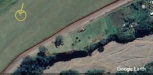
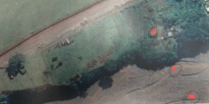
Just to let you all know what happened. The GPR did not detect an anomaly in the location where all of the data indicates the target should be. There were doubts that the operator of the GPR had a full understanding of his equipment. He was hired from outside. Some believe the object could have sunken down to a deeper depth over the past 80 years. For me, I think its possible I dowsed the original burial location and a phantom signal from the golden cache. Out of several young men at the time who buried the treasure, at least one would have surely managed to return and retrieve it. The target that I originally produced was from asking the question "Where did ____'s friend ____ bury his gold?". I was given a large area with no prior knowledge of anything beyond that a cache of gold bars should be buried within an area which encompassed the entire airfield and everything south between it and the river. The resulting location was exactly 100 ft north of a small bend in the river in a place which perfectly matched the original map and description given by the original depositor. Upon excavating 2 ft off the top of a large area with my point in the center, they unearthed the fuel drum in a location which can be safely assumed was the fuel dump based on the original description of the area. It was exactly 100 ft north of my point. So we have two of the major landmarks, the small bend in the river and the fuel dump, exactly 100 ft north and south of my point. Artificial spacing. This is significant and does give a great deal of validity to my initial result.

So the real questions are...

Was our GPR and operator up to the task?

Did the treasure sink down over the years to lower depths and out of range of the GPR?

Or, did someone already come back and retrieve it?

The object was described to be a tight group of large 50 lb gold bars the size of loafs of bread, that would have dimensions of roughly 2x2 ft. The Australian said they had all been trained to dig 4 ft shallow graves and that is what they did in this case. So the original depth would have been only 4 ft. It was discovered that at some point after the war someone covered the entire area with about 2 ft of top soil. This area is extremely dangerous and remote. Organizing this whole operation took quite a lot. There were a group of armed gunmen guarding us at all times. So it's hard to imagine a lone Australian managing to get back there and dig up the gold after the war without anyone else knowing. But of course, it's certainly not impossible. Anyway, maybe another time in the future we can get back there with better equipment. Thanks and sorry for the late update.
 

I should add that it's also possible natives dug up the gold. Either by accident or because someone was hiding in the bush and witnessed the burial. Lots of possibilities. But I think its probably safe to assume for everyone that the Australian fellow, who was on his way out at the time, had no reason to fabricate the story and map to his lifelong friend. His wife was present at the time this was revealed and she expressed her frustration that her husband "had waited all his life to go back for the gold and was now expecting someone else to do his dirty work." So certainly there was strong reason to believe in the existence of the cache. But now I fear it has been recovered by an unknown third party. At four feet, with that GPR unit, I think even a small child could learn how to detect an object like this. It's possible it sank but definitely not beyond the 20m capability of the GPR. And we scanned a huge area. So I think it is time to move on.
 

Last edited:
A portion of the story I left out was, there was a Jewish fellow among the unit who managed to smuggle his gold bars out of Papua New Guinea by smelting all the bars in to the shapes of tools and painting them grey. He became a very wealthy man. This ambitious fellow would have known about the other caches. 😢 So, who knows.
 

Last edited:
The object was described to be a tight group of large 50 lb gold bars the size of loafs of bread, that would have dimensions of roughly 2x2 ft.

An average loaf of bread would be roughly 6" X 6" X 12". I believe if made from gold that it could be in the 50 lbs. range. Not sure, as I've never seen nor tried to pick up a gold bar that size.

2x2 ft. is pizza sized.
eating-02.gif
 

A mining company owns the property.
Red, we managed to form an agreement with the mining company. The only obstacle now is actually locating the treasure, if it's still there. I was the one who talked to you about this site previously as well. Thanks
 

Australian said they had all been trained to dig 4 ft shallow graves and that is what they did in this case. So the original depth would have been only 4 ft

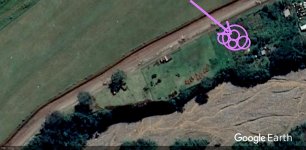
If you can think back to the last thing I marked on the map, seemed like a possible grave (or graves}. Of course, you could expect that since a battle was fought in the area. Same is true of Japanese WW2 tunnel and bunker entrances also.
 

Attachments

  • signal-2022-par.jpg
    signal-2022-par.jpg
    121.5 KB · Views: 21
An average loaf of bread would be roughly 6" X 6" X 12". I believe if made from gold that it could be in the 50 lbs. range. Not sure, as I've never seen nor tried to pick up a gold bar that size.

2x2 ft. is pizza sized. View attachment 2106928
Close DizzyDigger. 69 pounds of gold per loaf.

I don't know of any smelters that have ever produced 50 or 69 pound gold bars. It would be interesting if someone knew the processor for the "most productive gold mining area in the world" and what size bars they produced. I'm guessing the OP is referring to South Africa, Canada or the United States? They were by far the most productive gold mining areas in the world during that time. I'm not sure why any of those countries would have the Japanese bury their gold in another country and they certainly weren't invaded by Japan but I guess stranger things have happened.

Interesting story. Too bad science didn't back up your hunch. It probably wasn't cheap to hire professionals for the GPR.
 

An average loaf of bread would be roughly 6" X 6" X 12". I believe if made from gold that it could be in the 50 lbs. range. Not sure, as I've never seen nor tried to pick up a gold bar that size.

2x2 ft. is pizza sized. View attachment 2106928
I would think loaf describes the shape more than the size. If you are talking about home baked bread which has to be put in a warm place to raise.

WW2-Japanese-gold_bar.jpg


Photo sent me from a treasure hunter searching in the Philippines years ago. I had about a 3 or4 year contact with him. He told me the username of TN member who found the gold cache. Hard to remember names since I started helping him back around 2012-13.


WW2-Japanese-gold_cache.jpg


I was assuming this was a Japanese find.

WW2-Japanese-gold.jpg


Cache contained jewelry and coins also.

WW2-Japanese-gold_bar2.jpg


This photo of gold bar might be a little better. Whether Japanese or not, looks like a lot of gold.
 

Last edited:
If you can think back to the last thing I marked on the map, seemed like a possible grave (or graves}. Of course, you could expect that since a battle was fought in the area. Same is true of Japanese WW2 tunnel and bunker entrances also.
Red, that area is where we were operating. Your circles cover most of the northeastern portion of the target zone. My target was basically on the southwestern edge of your outermost circle. All of that area was scanned by the GPR.

Maybe you picked up the empty graves where the caches were formerly buried? Maybe both of us did, for that matter.
 

That is quite possible I believe. On your large map (in the other thread) the river runs through mostly on the right side. Don't have any maps marked yet but would rather give you a PM. Have there a place I'd kept getting a gold hit but probably native gold good for mining. Then up from there a place signal similar to what I get on Philippine Japanese WW2 sites. If or when the maps get done, I'll send you a private message. It could be a battle site, we won't know until taking a look at it.
private message.
 

Sent you map, might as well post here also. Gold only hit.

Papua-New-Guinea_LG=400+ E=S29+B-gold.jpg


I'm thinking maybe there is a cave inside bend or point.

Papua-New-Guinea_LG-A4=400.jpg


Gold hit would be in this area here.

Papua-New-Guinea_LG-A2.jpg
 

Last edited:
dowsing history lesson acts chapter one verse 24 supports chapter2 verse 4 thats how i dowse no stinken meta physical your dealing in the spirit zone found lots of nuggets here on salmon river idaho matter of fact heading to florence basin idaho sat. have located major strike in hard rock on 394 road i believe this is the biggest in the basin bigger than anything found in the 1860,s i,am on yahoo tomato hill@ yahoo .com i'run half mile of plcer tunnel also hard rock if i can help let me know tunnels and graves are easy to find go to todd hofflander on u tube i'am there finding todd at bernard creek hells canyon
 

nothing there but found henry plummer gold at spencer beaver canyon idaho bird tail idaho and st peter mont. rogerson idaho robbers roost idaho lava beds new mexico ,,,,,,,,,,,, spanish silver and gold coins found,,, like dutch schults or or belle star is found dents run is gone or never was there ,, grant marsh up the little big horn have found many nuggets and pay streeks and hard rock vein structures salmon river idaho tomatohill@yahoo i can tell ya how deep and how much been at it for over 30 years ya got to what your doing or you will end up on the wrong trail lollol expectations will fool ya ,, wildcat blm 6miles north of riggins idaho portal 20 ft from fog line another hit on moores crrek out of boise idaho i have contacted finders keepers and bob thomason and iam member of gpa and take the cali mining jounal for 40 years where i live is robbers gulch its gone posse caughtem with their pants down killed both and hauled their bodies down to riggins and buried them on the old trail on the forest service about 600 ft from us 95 goen out of riggins south i found them the rocks are still there marken their graves .. i know what iam doen also located chink graves across the river tom lindsey
 

Top Member Reactions

Users who are viewing this thread

Back
Top