Claimed?

NuggetN8

Hero Member
Mar 13, 2012
618
416
Northern California
Detector(s) used
SDC 2300
Primary Interest:
Prospecting
Is there any way to see what areas are claimed on a map? I've looked at addons for google earth that show claimed areas but it doesn't guarantee that it's accurate or up to date. If you go in to the BLM office for your state do they have a map you can view showing accurately where claims are?
 

Upvote 0
No, the BLM doesn't map them, or provide maps of them. I once found a map that the claim owner had made. Those maps were in their corner stakes. I asked at the BLM office, because I assumed that the BLM had made them. They were surprised at what I had found.
 

No, the BLM doesn't map them, or provide maps of them. I once found a map that the claim owner had made. Those maps were in their corner stakes. I asked at the BLM office, because I assumed that the BLM had made them. They were surprised at what I had found.

Well that sucks. I guess the best way to know if a place is claimed or not is to just go to where you want to try and look for signs.. The thing is I've seen some places in my area that had claim signs and recently I drove past where it was posted before and it's not anymore. So either somebody vandalized their claim and took down the signs or they abandoned it or something..
 

You should start with the LR2000 on the BLM site. Use it to find the areas you are interested in. Then, look at active claims. You can add up all the claims in a given "section" and subtract that from 640. 640 acres to a section, (1mile by 1 mile). That will give you an idea if any land at all is available. You will need a map which shows township, range, and section boundaries. You also will need to know the meridian that you are looking at. Also, you need to look at the claim ownership list very closely. I have found sections that ended up with well over 640 acres claimed up, and found out that when there are multiple owners listed for a claim, the BLM will list it once for every owner. The best thing you can do, is go to your local BLM office, get the township, range, and section map you need for your area, and have a nice long conversation about how to use the LR2000. Good luck.
 

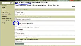
When selecting the report you want to run
geo.JPG
 

When selecting the report you want to run
<img src="http://www.treasurenet.com/forums/attachment.php?attachmentid=766530"/>

Wow... That was really simple..Thank you so much!!!! I've been stumped in this all day lol. Forgot about that selection before I got to the page I was on.
 

I've been using the LR2000 system for planning an upcoming trip, and although
it can certainly provide the needed data, it's a PITA when you are looking at many
areas in general, and just want to be sure you're not poaching someone's claim.

Best solution I've found is using the Google Earth program, and then adding
Mine Cache software. Mine Cache has really improved, and you can select either
OPEN or CLOSED mines, or you can view all mines in the area. You won't get
exact dimensions, but you will get boundaries showing the edges of claims.
Mine Cache accesses the BLM data directly, so it includes all the data you
would find via the LR2000 system, but in this case the results are displayed
on the map itself.

For closed claims, once you click on the mines name you get a pop-up with
all the pertinent data, including a link that you can use that allows Mine Cache
to access and then provide the info direct from the LR2000. Could not be any easier.

Mine Cache does cost about $30.00 per year, but with what it provides I can certainly
see the value and time savings for nugget shooters, etc. researching areas they can
access.

MineCache.com - Home - Gold Prospecting with Google Earth
report on that claim
 

Last edited:
I've been using the LR2000 system for planning an upcoming trip, and although
it can certainly provide the needed data, it's a PITA when you are looking at many
areas in general, and just want to be sure you're not poaching someone's claim.

Best solution I've found is using the Google Earth program, and then adding
Mine Cache software. Mine Cache has really improved, and you can select either
OPEN or CLOSED mines, or you can view all mines in the area. You won't get
exact dimensions, but you will get boundaries showing the edges of claims.
Mine Cache accesses the BLM data directly, so it includes all the data you
would find via the LR2000 system, but in this case the results are displayed
on the map itself.

For closed claims, once you click on the mines name you get a pop-up with
all the pertinent data, including a link that you can use that allows Mine Cache
to access and then provide the info direct from the LR2000. Could not be any easier.

Mine Cache does cost about $30.00 per year, but with what it provides I can certainly
see the value and time savings for nugget shooters, etc. researching areas they can
access.

MineCache.com - Home - Gold Prospecting with Google Earth
report on that claim

Yeah I've tried that one for free (7 day trial period). Wasn't sure how accurate it was so I did the LR2000 and it spits out the same info. I figured out that there's so many claims in my area that both of them aren't of much use to me because every place that is claim able is claimed. I would suggest using mine cache to anyone out there that doesn't feel like taking the time to punch in a bunch of numbers to see what's claimed or not claimed.
 

Find the thread in here by Terry C. and he has instructions on how to use LR2000. Also there is a site called Mine Cache that has all the claims and works with google earth . It is a free trial and then I believe $29 a year after that. It wasn't very good when I tried it when it was new but the designer said he has fixed and improved it. I don't know for sure as I have claims and don't need to find any so it is a crap shoot.

Good Luck!

B H Prospector
 

Put some thought into learning how to read A Master title plat and a land description Diagram as once you figure out the lr2000 all it does give you a description and it is up too you to properly read the info and figure out the claims boundries..And then their are Gulch claims and those basterds had me stumped for sometime...I never tried any map overlays for claims.. As I figure its probaly best to do it yourself as the knowledge will prove of value to anyone who enjoys prospecting.. I admitt I still have trouble in this area but I think time will soon take care of that..
 

Top Member Reactions

Users who are viewing this thread

Back
Top