Yesterday I Was Detecting In The Woods Unknowingly Downwind of a Control Burn Area

  • Thread starter Thread starter Deleted member 140734
  • Start date Start date
D

Deleted member 140734

Guest
That was a new sensation. I was about a half an hour's hike into a large section of woods detecting. Beautiful blue sky day, but only in the upper 30s to low 40s with a strong and cold wind from the NW. I was detecting in small rolling hills that are pretty heavily forested with mostly mature oak trees. Woods that I know very well, perhaps better than anyone else alive. Trying to get into some tick infested areas before they fully emerge. The ticks are definitely out and have been for weeks. I see them in temps above the high 30s. If you scrape the leaf matter with your boot down to soil, you see many varieties. If you stop long enough you can see some starting to move up your boots. But I know how to deal with them and they never successfully feed on me.

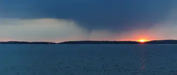
Around midday I started to smell smoke. A strong piney smelling smoke. It was too windy for any smart person to build a campfire. It was close enough to see smoke moving quickly around me, for my eyes to burn, and to start coughing some. I could see haze on the NW horizon. I started Googling fires in my county but nothing came up. I ended my day early. The closer I got to home about 10 miles away, the clearer the air became.

Later last night I read a bulletin that the authorities did a control burn at the Nature Conservancy's Mashomack Preserve on Shelter Island, over 2,350 acres of interlacing tidal creeks, mature oak woodlands, fields, freshwater marshes and underwater lands. Located just a few miles to the NW across an ocean channel from where i was detecting, I must have been directly in the smoke funnel. They must have started the fire on SE corner of the preserve surrounded on three sides by water, letting the high winds push the flames towards water.

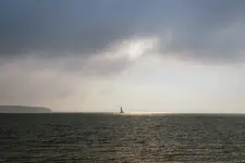
I have never seen a controlled burn in my 30 years of living on the eastern end of Long Island on the South Fork. We have had some brush fires break out, usually in conjunction with dry summer heat waves. We recently had a series of large fires earlier this month which were successfully contained without major damages. What makes it unnerving is, starting about the last decade or so, Southern Pine Beetles (SPB) have ravaged our pine barrens regions, affecting all pine tree species, but especially our pitch pines. Large areas look like wastelands with mature trees lying dead. So we have a lot of dead brush accumulating. After what happened in SoCal recently, it has made everyone a little nervous. During the mid-1990s, we had large pine barrens fires to the west of me near Brookhaven Labs. Between 1965 -1996, the lab operated a nuclear research reactor that provided neutrons for scientific experiments. Given that my area has only one major road out of the region, fires are in our minds.
 

Fires are definitely scary. I do controlled burns on my 2 acres of restored prairie. Even with only 2 acres my adrenaline gets going when I light it up. A wall of fire races across the grass. Living in Central IL is low risk for any major wildfires. The only timber is along rivers and streams or isolated patches. All surrounded my thousands of acres of plowed ground. If a fire does start it can’t go very far.
 

Have you ever detected in that forest before?
It would be a good area now having the under brush burnt back, and the ticks getting bbq'd.
 

Fires are definitely scary. I do controlled burns on my 2 acres of restored prairie. Even with only 2 acres my adrenaline gets going when I light it up. A wall of fire races across the grass. Living in Central IL is low risk for any major wildfires. The only timber is along rivers and streams or isolated patches. All surrounded my thousands of acres of plowed ground. If a fire does start it can’t go very far.
I can't imagine living an open horizon with wide open vistas. Well, we do have that with the ocean. It's funny. I live in the sheltered bays of the inner fork of Long Island. I prefer that small town New England feel. A few minutes drive away is the open Atlantic, but I don't spend much time there! And I did live for a time in the Serengeti. I actually feel a bit claustrophobic when all of the trees leaf out. I lose sight lines and reference points in the forest. I also can't imagine being in a huge dust bowl type storm. Or feeling vulnerable when lightning strikes or tornadoes spin through. Spring prairie flowers must be beautiful. I guess every ecosystem has its vulnerabilities. For us it"s hurricanes and Nor'easters. Gone are the days of heavy snowfall.
 

Returning fire to nature is essential. Allowing the government to plan and execute is a very big mistake. Locally our USFS uses the horrific summer wildfires as a way to burn the forest. It’s devastating to basically everything. They will bear no responsibility and will not admit to doing this. Last summer, they wanted to reignite a huge wildfire and burn another 28 square miles in the name of controlled burn because the terrain was too dangerous for boots on the ground.
Conveniently, endangered species be dammed.
They force locals out of the area and you have to cross your fingers if you have a home at the end.
 

Have you ever detected in that forest before?
It would be a good area now having the under brush burnt back, and the ticks getting bbq'd.
I was thinking the same thing. Although it is close as the crow flies, it takes some driving and a ferry ride to get on and off of Shelter Island. It suffers from a large, almost pestilent population of deer and ticks. Historically it is an interesting place. It was listed in the original Plymouth Company land grant in 1620 and settled a few years later. It was part of the triangular slave trade with Barbados and had a slave population (and has a historic slave cemetery). It was like much of my area, at one time provisioning the sugar islands with cattle, foodstuffs, and oak barrel staves for the rum industry. Most interesting, historically it was the home to Grand sachems for several regional Indian tribes and abounds in burials. It makes development there tricky, every time they break the earth to develop. As an archaeologist I feel that mojo, it is hallowed ground. I can see it in the near distance, across the water, and it even appears mythical at times.

The problem detecting there for me is that I long longer have contacts living there. I had a close friend with a 9 acre farm who passed years ago. I would prefer to venture into a new area with a base and local contacts.
 

They force locals out of the area and you have to cross your fingers if you have a home at the end.
I can't imagine the possibilities for what might go wrong. I found that smoke to be irritating and tough to breathe. And the devastation to certain wildlife species. Some lose and some gain. For example, our wetlands have become degraded and grown it. Waterfowl need clear lines of sight in and out. These used to be critical stops on the Atlantic flyway. The colonials turned lose their flocks and herds to chew down everything. The natives and colonists used fire as a land management tool. Where I live contains some of the most valuable land and homes in the country. Insurance companies get excited about property losses. And the hedge fund managers and Wall Street Investors with second homes have insurance assets in their portfolios!
 

I can't imagine the possibilities for what might go wrong. I found that smoke to be irritating and tough to breathe. And the devastation to certain wildlife species. Some lose and some gain. For example, our wetlands have become degraded and grown it. Waterfowl need clear lines of sight in and out. These used to be critical stops on the Atlantic flyway. The colonials turned lose their flocks and herds to chew down everything. The natives and colonists used fire as a land management tool. Where I live contains some of the most valuable land and homes in the country. Insurance companies get excited about property losses. And the hedge fund managers and Wall Street Investors with second homes have insurance assets in their portfolios!
Insurance companies have canceled most policies covering wildfire. It’s an emergency economy. The only time they can get resources is during a wildfire so they attempt to control the fire at a slow rate all through summer until it is rained out. This last summer it got rained out early not even smoke showing and they wanted to start it back up in mid. September. It’s weird out west. Problem is it nukes parts of the forest and kills everything in its path. The though of burning in later fall doesn’t exist.
 

Insurance companies have canceled most policies covering wildfire. It’s an emergency economy. The only time they can get resources is during a wildfire so they attempt to control the fire at a slow rate all through summer until it is rained out. This last summer it got rained out early not even smoke showing and they wanted to start it back up in mid. September. It’s weird out west. Problem is it nukes parts of the forest and kills everything in its path. The though of burning in later fall doesn’t exist.
We usually have abundant rainfall. The pine beetle scourge has really left a lot of deadwood laying around. But insurance companies have cancelled policies in our area due to flooding from hurricane surge and rising sea levels. People think global warming and rising sea levels are hogwash. Where I live it's a real thing. Proof is in the mature hardwood trees dying around our harbor from their feet getting soaked.
 

I was thinking the same thing. Although it is close as the crow flies, it takes some driving and a ferry ride to get on and off of Shelter Island. It suffers from a large, almost pestilent population of deer and ticks. Historically it is an interesting place. It was listed in the original Plymouth Company land grant in 1620 and settled a few years later. It was part of the triangular slave trade with Barbados and had a slave population (and has a historic slave cemetery). It was like much of my area, at one time provisioning the sugar islands with cattle, foodstuffs, and oak barrel staves for the rum industry. Most interesting, historically it was the home to Grand sachems for several regional Indian tribes and abounds in burials. It makes development there tricky, every time they break the earth to develop. As an archaeologist I feel that mojo, it is hallowed ground. I can see it in the near distance, across the water, and it even appears mythical at times.

The problem detecting there for me is that I long longer have contacts living there. I had a close friend with a 9 acre farm who passed years ago. I would prefer to venture into a new area with a base and local contacts.
The first shot I took is of the area on Shelter Island where they did the control burn. The setting sun during a passing cloud burst is ironic because it looks like fire. The second is normally how I see Shelter Island, its eastern heights. A pirate looking vessel is kind of appropriate.
 

Attachments

  • shelter1.webp
    shelter1.webp
    269.3 KB · Views: 6
  • shelter2.webp
    shelter2.webp
    507 KB · Views: 6
NICE GOING !!! Good story and thank you for sharing with us
 

Top Member Reactions

Users who are viewing this thread

Latest Discussions

Back
Top Bottom