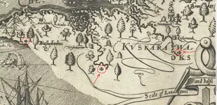
X marks on an old Maryland map

Capt.Betances

Full Member
Joined
Mar 27, 2012
Messages
216
Reaction score
71
Golden Thread
0
Location
Franklin, NJ (for now)
Detector(s) used
Garrett ATMAX, Garrett GTI 2500, Sea Hunter Mark II, Garrett ACE 400, Minelab X-Terra, Garrett Pro Pointer, Garrett Pro Pointer AT, Eagle Eye, LRL, Audio generator app Tone, home-made dowsing L-rod,
A
Primary Interest:
All Treasure Hunting
Hi everyone

Making some research in Old Maryland maps before 1650, I found an old map of 1612. When I look it, I noticed there is several X marks in the map. Most them are located close to some river.( see my pic). What does means those X marks?


Red X.webp
 

I live in lower Maryland on the eastern shore and I would love to come across something more historic than the occasional copper. We had no civil war battles or significant revolutionary war battles.
 

i dont think anyone has claimed to have found, any of the carved or brass
crosses to date, maybe you will, if you do please post an img, the link above
says the brass crosses were attached to trees

large map Cross Locations
http://smith.npschesapeakebay.net/images/content/smithmapcrosses.jpg

CW

it is pretty hard to find those tree that you mention because the old of the map. Beside, today, that area that I show in the partial map is completely farms.
 

Top Member Reactions

Users who are viewing this thread

Back
Top