does anyone have a explaination what a windrose might be?
Navigation
Install the app
How to install the app on iOS
Follow along with the video below to see how to install our site as a web app on your home screen.
Note: This feature may not be available in some browsers.
More options
You are using an out of date browser. It may not display this or other websites correctly.
You should upgrade or use an alternative browser.
You should upgrade or use an alternative browser.
wind rose
- Thread starter hadji009
- Start date
goldguru
Sr. Member
- Aug 24, 2005
- 465
- 7
Leones Corazon
Full Member
- Mar 26, 2006
- 169
- 46
- Detector(s) used
- Whites TM 808
Equinox 800
Go Find 60
- Primary Interest:
- Other
Leones Corazon
Full Member
- Mar 26, 2006
- 169
- 46
- Detector(s) used
- Whites TM 808
Equinox 800
Go Find 60
- Primary Interest:
- Other
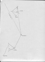
The picture was posted years ago on another forum if i member right.
It was basically used to triangulate an object when a hill was in the way.
Say....drill hole....pull your xxx degree line....walk it and find the window
that shows you whats around the corner...
DW
It was basically used to triangulate an object when a hill was in the way.
Say....drill hole....pull your xxx degree line....walk it and find the window
that shows you whats around the corner...
DW
rangler
Bronze Member
- Jul 12, 2004
- 1,320
- 201
- Detector(s) used
- for solutions to the jesuit code -email pics to: [email protected]
;[email protected] locations needed! oro bro!
- Primary Interest:
- Other
I dont believe it could be nothing else but the
Compass Rose!
a variation for weather people was the wind rose,
someone confused the data only a compass
could be used to do to what Leones so graciously
posted
Its called the FREE FLOW of information dude! It happen in a free society, easier with
out critics like you with NO experience, commenting on a hobby you lack the expertise in,.
as for authenticity, it is WE treasure hunters or PROVE or Disprove the data we get - out in
the field, where the boot leather meets the trail , something you only READ about!
We dont need a superfluous filter like you offer , we dont live in some nanny state
where must be protected from our selves!!
This is meant sincerely:
Take a Hike!
rangler
Compass Rose!
a variation for weather people was the wind rose,
someone confused the data only a compass
could be used to do to what Leones so graciously
posted
That seems like the typical scenario for Treasure Marks/Signs.
Things get copy/pasted from one internet forum to another and gains authenticity.
Its called the FREE FLOW of information dude! It happen in a free society, easier with
out critics like you with NO experience, commenting on a hobby you lack the expertise in,.
as for authenticity, it is WE treasure hunters or PROVE or Disprove the data we get - out in
the field, where the boot leather meets the trail , something you only READ about!
We dont need a superfluous filter like you offer , we dont live in some nanny state
where must be protected from our selves!!
This is meant sincerely:
Take a Hike!
rangler
lamar
Bronze Member
- Aug 30, 2004
- 1,341
- 50
Dear group;
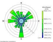
A wind rose was a navigational tool most widely used on charts before the advent of the magnetic compass and it placed the cardinal points (or directions) of the prevailing winds, along with their seasonal times. Please note that the wind directions were always the same as is found on the modern day compass rose, and after the compass rose became poular, wind directions were then annotated by a caricature ball of clouds puffing winds in a certain direction.
As the magnetic compass gained popularity, the wind rose gradually feel from disuse on oceanic navigational charts, however wind roses are currently employed by NOAA and other mapping agencies to show prevailing wind directions and velocities over any given period of time, that generally being 30 or 40 years. Wind roses are still in use for airports and with some wind powered sailing competitors.
Your friend;
LAMAR
Attachments
Old Dog
Gold Member
Thanks Bob and Lamar ,
Both very informative links,
Note that pre-compass this was used as a way to orient on land as well as the sea.
the point marked as 'windrose' on the drawing should be a very fixed and permanent point.
there should be a set of radiating points that establish direction as well.
they may be complete or partial, but there should be indicators present to give pertinent information about the local.
K
Kentucky Kache
Guest
SWR said:All members are equal, regardless of age, gender, ethnicity, education, or experience. Never take a superior tone with, or "talk down" to, anyone.
I hope Lamar sees this.
CanadianTrout
Hero Member
I sent a PM to kidrock and I had hoped he would post here. Somewhere else on TNet he posted info and pics regarding a windrose he had found out in the bush. Not a true "compass windrose", but something very similiar to what Leones posted.
I believe the fixed point was a drill hole in a rock. I'm sorry i don't recall how exactly it all worked but using this fixed point and various degrees he had obtained somehow/somewhere it made a triangle. When he measured off the degrees and went the required distance it lead him to another sign. It was either buried iron pieces or another stone carving/sign. All pieces of the puzzle of his potential treasure site. Which i may add here, he has stopped posting pics and info on the trail he was following thanks to a certain few. Thanks for that guys, well done.
Does anyone else recall Kidrock's windrose post/pics, or am i off my rocker here. Maybe i have him confused with another poster....
I believe the fixed point was a drill hole in a rock. I'm sorry i don't recall how exactly it all worked but using this fixed point and various degrees he had obtained somehow/somewhere it made a triangle. When he measured off the degrees and went the required distance it lead him to another sign. It was either buried iron pieces or another stone carving/sign. All pieces of the puzzle of his potential treasure site. Which i may add here, he has stopped posting pics and info on the trail he was following thanks to a certain few. Thanks for that guys, well done.

Does anyone else recall Kidrock's windrose post/pics, or am i off my rocker here. Maybe i have him confused with another poster....
desertmoons
Bronze Member
- Apr 16, 2008
- 1,067
- 168
Thanks lamar and bob,and rangler.
If windroses are used on land maps...it makes me wonder why.
Land surveying has gone on a long long time. Just search the net for roman surveys etc for example. Surely that information would have passed to many cultures..
So why use something more related to winds and sea navigation rather than the more land based "traditions".
Old Dog
Gold Member
desertmoons said:Thanks lamar and bob,and rangler.
If windroses are used on land maps...it makes me wonder why.
Land surveying has gone on a long long time. Just search the net for roman surveys etc for example. Surely that information would have passed to many cultures..
So why use something more related to winds and sea navigation rather than the more land based "traditions".
Because at the time these were used there were only Astrolabes and such to navagate with.
There were no campasses.
These guys used the same equipment to navagate on land as they used on the sea.
desertmoons
Bronze Member
- Apr 16, 2008
- 1,067
- 168
Thanks Thom!
Kim
Kim
kiddrock33
Hero Member
i believe chains were used to measure i think its called a Gunter chain or something spelled similar. i believe triangles show how a mine is dug. and slope of hill, it shows the tunnel , shaft and slope. it determines mine ownership and bounderies, this way a neighboring mine will not invade anothers claim.
Top Member Reactions
-
 2708
2708 -
 1996
1996 -
 1663
1663 -
 1661
1661 -
 1198
1198 -
 1010
1010 -
 966
966 -
 929
929 -
 860
860 -
 797
797 -
 779
779 -
 509
509 -
 440
440 -
 413
413 -
 381
381 -
E
370
-
 367
367 -
 354
354 -
 354
354 -
 350
350
Users who are viewing this thread
Total: 2 (members: 0, guests: 2)


