When to call it a year?

Sugarcultmillionare

Tenderfoot
Sep 26, 2018
6
6
Primary Interest:
All Treasure Hunting
Iā€™m in California so that is where I prospect, more specifically colfax, ca and Iā€™m thinking about checking out the Mokelumne river. Iā€™m just wondering when do you call it a year. Because I still want to go out and Im Just curious the impact the few rains weā€™ve had is on the river. But I donā€™t want to waste my time. The equipment I have is basically pans and a sluice.
 

Upvote 0
Never give up. If the ground isn't frozen, it's treasure hunting season.
 

Keep going I agree with Icewing. Sometimes when metal detecting you find something real good just before you give up. Good luck.
 

Call it a year when they throw dirt in your face OR when your heath prevents it like me! But I still want to get out even though I know I cant physically do it anymore!
 

Haha got it.

Most of the Moke river is owned by EBMUD or is claimed up.There are some open spots however.

That was another question I had. Can someone point me in the right direction (besides google) where I can find what portions of rivers are and arenā€™t claimed? If its owned by EBMUD does that mean itā€™s off limits? I went out to big bar a week back and seen a couple guys prospecting.
 

Haha got it.


That was another question I had. Can someone point me in the right direction (besides google) where I can find what portions of rivers are and arenā€™t claimed? If its owned by EBMUD does that mean itā€™s off limits? I went out to big bar a week back and seen a couple guys prospecting.

Dude your so close to so much. save your gas money.
 

I wouldn't quit. What else you gonna do?
 

Don't know what's open or not.EBMUD has their own police that patrols occasionally...and it was designated a wild and scenic river..don't know if that's all the river or just parts of it.
 

There is an app called minecache that shows where all claims are it has a seven day free trial.Then it is a charge by the year app,It is a google app.
 

There is no federal Wild, Recreational or Scenic River designation on the Mokelumne. The State of California designated the 37 miles between Pardee and Salt Springs reservoir as State wild and scenic in June of this year. All that means is at the state level that new dams cannot be built on the protected stretches of the river, and existing dams cannot be raised - by the State.

You can see the same, and often more current information for mining claims on Land Matters. The price is free, it's updated more often than the paid versions and you can see which management agencies etc. are where. In addition you can see patents, old mines and download the Master Title Plat for the area you are interested in.

EBMUD doesn't own any part of the river. It's actual "ownership" extends to two reservoirs, Pardee and Camanche; the Mokelumne Aqueducts, which convey water from Pardee Reservoir to the East Bay and hydroelectric generation facilities at the base of the Pardee and Camanche Reservoirs. Above Mokelumne Hill they have no ownership interests. There are several other water and management districts involved in watershed management throughout the Mokelumne but none of them own any part of the river. They just own and manage the facilities associated with the distribution and management of water rights for their members.

I haven't worked the Moke. I was lead to believe that, other than a few small placers, there was not much there for the little guy so I never bothered. As mentioned by others there are probably more productive areas near your current location. Maybe someone else can fill you in on where there might be gold worth mining on the Mokelumne. :thumbsup:

Heavy Pans
 

Season never ends in Cali. Dress correctly and gold all year long baby!
 

For most of us here in Illinois, season ends when everything freezes solid. Not for me however. Every time I go prospecting I bring a couple buckets of gravel back and dump them in the basement corner next to the wood stove. Now when it's 20 below outside I can set by the cozy wood stove and pan to my hearts content.
 

Sugarcultmillionare, Clay just gave you the site for learning who owns/claims what & where. As gravelwasher has indicated You ARE right in the middle of So Much! Have you panned any of the dirt in your own yard?

As far as what the rivers are doing, I use USGS Real Time Water Flow Data in the search line on my computer and then click on whatever river in California I want water flow data on. There is at least one other water flow information source however, I do not have its web address, someone here will likely chime in with it.

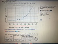
The USGS Data will give you, among other things, Cubic Feet Per Second information (CFS) for the water source you are looking for AND they will show a graph based on the approximate time of day, date & CFS flow rate. Use the water flow data as a guide and then go look at the water you are interested to learn when water is too dangerous to mess with, like spring floods!..............63bkpkr


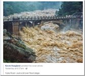
9777B58C35C14E38A872F011A7E5EF4A.jpg This would be an example of a "Real Spring Flood", Yuba river. Compare this to the pictures
Asmbandits posted below of the NFAR (North Fork of the American River) of an end of November trip.


IMG_4353.JPG Here is a screen shot of the USGS Real Time Water Flow Chart for the NFAR which shows a reading
of about 600 cfs today at about 1 PM but as of this evening 11/24/2018 at about 10 PM it has begun to taper off to about 540 CFS. To the left of the screen shot you can also see that the river flow on November 21 at 1 PM was 50 CFS and then started going up due to the rain in the mountains outside of Auburn. It takes a while for the river flow to react to the rain as most of the rain falls on the hills/mountains and must collect and drain down to the river and then it must get down river to where it is being monitored, a bit of a time lag! If a person does not stay up with the events around them then they could be drowned by the quickly rising water. Also, the water right now is going to be quite cold so a human in good shape would last about 45 minutes in it before they lost consciousness due to hypothermia IF they did not first suffer serious injury from the water slamming them into a boulder. Just FYI Also, the NFAR has been running at about 50 cfs or less for several months now, drought values.


Last edited:
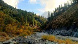
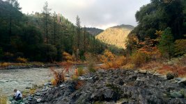
I just got home from prospecting on the north fork American river about 15 minutes from Colfax. It was a beautiful day out and I was properly equipped for the season and was warm even with the low temps and being in the water. If your in Colfax you are very central to so much gold bearing area I would love to live up there!

P_20181124_142523_HDR.jpgP_20181124_142559_HDR.jpg
 

To Be On The NFAR in November

Hi Asmbandits, NICE Pictures! Really looks lovely out there, you lucky dog!! From the USGS chart I posted the river has been rising since the 21st so in the last three days it has been rising, were you there long enough to notice that it was rising? 600 CFS is a heck of a jump from 50 CFS, so was it raining while your were there and where you were our was it raining much higher up in the mountains? I would think you had a great time...............63bkpkr
 

Hey Herb! We really lucked out, everyone was telling us we were nuts and it was going to storm but everything I was looking at said it would be nice and it was. A little drizzle in the am but tapered of into a beautiful day, the fall colors really are in full force on the river. I did not notice the water level fluctuate at all but I do know the kayakers were in full force running this section of river, must have see about 40+ in total head down from us.
 

SCM. As Goldwasher states no reason to drive to the Moke when you have 3 forks of the American, The Bear and 3 forks of the Yuba Rivers near you. With the rain this week raising water levels and causing runoff you can work spots that are higher up or in gullies that usually donā€™t get worked. Keep care watch out for hillslides and rolling boulders on rain soaked mountain dirt roads and overall slippery conditions and you will do well. Happy Panning.
 

Top Member Reactions

Users who are viewing this thread

Back
Top