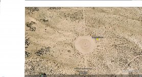
What is this?

Customx_12

Hero Member
May 22, 2008
547
305
Detector(s) used
Tesoro Silver uMax
Primary Interest:
All Treasure Hunting
I found odd circles on Google Earth. They're are some agricultural areas to the West but I'm not sure they're related. Any ideas on what they are?

The coordinates are:

33°02'28.88"N 115°17'04.83"W

I zoom in to about 80 feet above. Thanks!
 

Attachments

  • Odd circles.jpg
    Odd circles.jpg
    205.2 KB · Views: 387
Anyone?
 

Well! Damn! I went to the site and looked around to see what I could see, And There was nothing to see. Beats me! Maybe a well, Water or natural gas. Strange though.
 

Kinda right in the middle of nowhere huh? I'll bet a plane flying over could use that for a drop area, if you zoom in closer there are all kinds of ATV tracks.
 

Kinda right in the middle of nowhere huh? I'll bet a plane flying over could use that for a drop area, if you zoom in closer there are all kinds of ATV tracks.

Yeah, I noticed the ATV tracks too and initially thought that maybe it was some sort of track or something but the layout just doesn't make sense. Glad I'm not alone in being stumped by this!
 

So you're guessing that it used to be a target to practice bombings for the military? That sounds interesting but wouldn't they have it closed off to the public for safety reasons? Undetonated shells and all that?
 

Customx_12 said:
I found odd circles on Google Earth. They're are some agricultural areas to the West but I'm not sure they're related. Any ideas on what they are?

The coordinates are:

33°02'28.88"N 115°17'04.83"W

I zoom in to about 80 feet above. Thanks!

Its burningman spot??
 

Looks like instead of bombing drops it may be a training area for equipment drop for the military.
 

Top Member Reactions

Users who are viewing this thread

Back
Top