What is the best, Free Topo or gps software for a smart phone.

roadrunner

Bronze Member
Jan 28, 2012
1,230
524
Pinal Mountains,Arizona
Detector(s) used
Garrett Groundhog-2012-1st MD.
White's Goldmaster V/Sat-2nd-MD-2013
Tesoro Lobo-2015-3rd
Primary Interest:
Prospecting
I have been downloading and uninstalling different apps trying to find one I can put in Lat/Lon coordinates, and have them show up on a topo.
Been trying the Trimble apps, but they either show an ad in my search bar, or don't want to work right.
I have an Android system.
 

Are you trying to bring this device into the field? Or just to use at home?
 

Anywhere I go.
May just get a gps unit.
 

I use Back Country Navigator, it's great.

I got the pro version, $10. Worth it.
 

Thanks. Will Bc nav let me put in the Lat and Long, and then as I am walking towards it, show the directions, and also show the lat, long, as I am walking?

Right now I have the free version of GPS Essentials.
 

Last edited:
They all get service with a satellite,right?
Unless you are in a cave.
 

Thanks. Will Bc nav let me put in the Lat and Long, and then as I am walking towards it, show the directions, and also show the lat, long, as I am walking?

Right now I have the free version of GPS Essentials.

You can put in the lat lon of course and then navigate to it. I don't know if it shows the lat lon as you're walking - I don't see that as useful, and that coming from a math-compulsive former Great Lakes captain. It does have a compass.

I'm having some issues with the AccuTerra maps, but the free ones work fine.
 

I have tried to put in the lat long of 2 seperate apps,both free, and can not navigate to them for some reason.
Went to web site and followed the instructions.
Will look again in case I missed something.
 

Will have to try gps essentials again, or buy Back country nav pro.
I will re read the directions for gps ess.
Tried to put in a waypoint, then go to it, and it would not accept my new co-ordinates. Just showed my house again.
 

I did not know I had to format my coordinates.
Can't just put in long, lat like this.
33. 1412.74
 

There are many different formats to enter in latitude/longitude values. You just need to be aware of the format your software/GPS unit is expecting. Many apps/units default to WGS84 decimal degrees such as 37 23.516 -122 02.625 . You might also see values displayed as degrees minutes seconds ( N37 23 30 W122 02 37 ) and there are others. I'm not sure where you got "33. 1412.74" from in your post but it seems a rather odd value to me.
 

Yes you can, but in the options menu you have to select the applicable format for lat & longitude. I didn't know there was different ones either but, its kinda like sec min hours...
 

I went through the same issue last year and here was my solution in detail...

Sadly and most disappointedly, my phone (company) went to iPhone late last year,
so I have now picked up a Garmin ONLY because of this reason!!

One thing to remember! Using GPS (on any device) will SUCK your battery life...
so carry a spare or solar charger if you are going off-the-grid for any longer than 3-4 hours!!


I got in the habit of turning to AIRPLANE mode OR pulling the battery when not actively working
a pre-laid path/track into a location!!

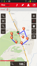
Anywho, the best FREE Android app I found after virtually trying them ALL...hands-down!

Orux Maps

AND
if you combine it with one of the online services listed below for UPLOADING and/or SYNC'ing tracks, waypoints,
pictures, etc...YOU BECOME A GPS ROCKSTAR (ALL FOR FREE)!!


Here's the "short-list" of a few of my most favorite features...
With OruxMaps you can:


  • Online maps can be cached for offline navigation.
  • Map Creator, from online maps to offline maps :hello2:
  • Offline map viewer. There is an application that lets you create calibrated maps for OruxMaps (see Download and Manual page).
  • Offline layered maps.
  • TrackLog: Record your tracks (gpx, kml format)
  • View old tracks/routes (gpx and kml format)
  • ....
  • Upload/download your Tracks from Everytrail.com
  • Upload tracks to gpsies.com
  • ....
  • Live Tracking with MapMyTracks.com
  • Show coordinates, header, speed, altitude, ...
  • And this is only the beginning!


qr.png

device_01.png A sample map...BUT they have topos, streets, even satellites!!!

Hope that helps you out!!

Take Care,
JC
 

Last edited:
There are many different formats to enter in latitude/longitude values. You just need to be aware of the format your software/GPS unit is expecting. Many apps/units default to WGS84 decimal degrees such as 37 23.516 -122 02.625 . You might also see values displayed as degrees minutes seconds ( N37 23 30 W122 02 37 ) and there are others. I'm not sure where you got "33. 1412.74" from in your post but it seems a rather odd value to me.

This is from Google earth, and a couple other places where I get my numbers from:
33 17'47.87" N 111 05'24.36" I meant this is how i put them in, I just did not post the complete formula in my previous post.
 

J.C, downloaded it now and will give it a try.
Thanks for all the info.
 

Check out ATVEscape and Topo Maps, both apps for the iPhone. I also use Google Earth, and AllTrails.
 

Top Member Reactions

Users who are viewing this thread

Back
Top