What Happened To Frog Island?

Zom

Jr. Member
Dec 8, 2019
81
42
USA
Detector(s) used
1975 White Discriminator. Sorry, my metal detector days are over.
Primary Interest:
Other
What Happened To Frog Island? (never mind, found it!!)

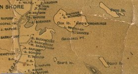
This is a screen shot from a recent Oak Island show of what I've read elsewhere is an old 1893 searcher map. It shows a Frog Island in Smith's Cove. Was it bulldozed over by Dunfield or Blankenship? What's also odd is it might be where the slipway is.
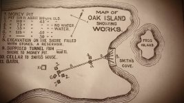
vlcsnap-2019-12-11-12h56m42s657.jpg
 

Last edited:
Not 100% on this but I think that map just shows it being closer then it really is. There is still another island out there today just alittle further away then that map shows...
 

Not 100% on this but I think that map just shows it being closer then it really is. There is still another island out there today just alittle further away then that map shows...

This map is clearly not to scale but the nearest island to Smith Cove is about 2300'. This clearly shows a small island... or maybe it's just a shoal, just off shore in Smith Cove. Perhaps some old photos might show it.
 

Last edited:
Here is more information about the map. The map was made by Church, A. F. (Ambrose F.)

Although Church copyrighted this map in 1864, it was not published until 1883. Church made maps of all the Nova Scotia counties during the 1860's, but publication on many of the maps was delayed until the 1880's for financial reasons. With insets of Lunenburg, Bridgewater, Mahone Bay, Chester Basin, Chester, and Nova Scotia. Shows locations of houses and names of property owners. The style of cartography is minimal, with no decoration or views, yet achieving a spare elegance. With black top and bottom rollers. Full color by township.

Here is portion in regards to Oak island.

1883 map of oak island.JPG

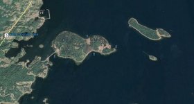
And google earth today below.

oak island.JPG

For me more interesting is landholders at the time in 1860's. However its interest to note the 1864 map completely missed one small island to the south east. Or did they could that small island has formed between after 1864 and present day. Whats does that say a tidal dynamics of the ever changing coastline?

Kanacki
 

Last edited:
That is the map I was telling everyone it has Frog Island as two islands. Not Oak Island as two Islands. https://www.davidrumsey.com/luna/ser...iew.search.url

It looks like the same dynamics that formed the OI swamp are at work here... the side away from the open ocean have filled in, and there's a barrier beach forming... though unlike OI, there's an inlet to the sea. No doubt it will fill in at some point leaving a swamp between the two islands.
 

Last edited:
Here is an explanation of tidal effects.


http://https://www.youtube.com/watch?v=p4qJVjw-DWI

A combination of these factors and geological factors accounts for formation of islands and disappearance of such islands is constant cycle of shifting material from the shallow sea floor creating barrier beaches than form in swamps them other time in land. There are many places all over the world that goes through that cycle.

That is why landholders of waterfront property over time either gain extra land or lose it.

In case of Frog island its pretty much explanatory.

Kanacki
 

Last edited:
It looks like the same dynamics that formed the OI swamp are at worker here... the side away from the open ocean have filled in, and there's a barrier beach forming... though unlike OI, there's an inlet to the sea. No doubt it will fill in at some point leaving a swamp between the two islands.

It has already filled in. And they dug there for treasure also in 1860's. There was a treasure buried there also but it had been recovered long before that time.
 

It has already filled in. And they dug there for treasure also in 1860's. There was a treasure buried there also but it had been recovered long before that time.

I was using the images from Google Earth which show the there's water in the space between the two Frog Island "islands" or perhaps like Oak Island they're drumlins. Am I mistaken but is this the first season in the show they're using that term? The images show an inlet in the barrier beach.
 

I was using the images from Google Earth which show the there's water in the space between the two Frog Island "islands" or perhaps like Oak Island they're drumlins. Am I mistaken but is this the first season in the show they're using that term? The images show an inlet in the barrier beach.

Then that space between is named nilmurd ( as per an old glacial geology professor ...)
 

Then that space between is named nilmurd ( as per an old glacial geology professor ...)

Drumlin backwards? That Oak Island is two drumlins (glacial deposits) raises questions about where's bedrock? And was that bedrock when they were investigation the "hatch" found on the old map provided by Zena Halpern.
 

Top Member Reactions

Users who are viewing this thread

Back
Top