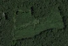
It's just clear-cut land.
Go to Google Earth, and search coordinates 38.94186, -76.19821
Then, in the menu bar, click the little clock with the left-facing arrow (to go back in time to view prior Google Earth images).
A scroll bar will appear at the upper left of the map. Scroll forward to Sept 2005 ("9/2005") and you can clearly see a clear-cut field of the same basic dimensions as shown in your map.
And especially so if you fast-forward to September 2007.
Now, what it might have been before that? Or, why this particular field is clear-cut is anybody's guess.
But probably just for logging? I don't see any evidence of structures of any kind.