BlackLine
Full Member
A new theory. Actually, I have nothing to do with Oak Island as I am looking for the Lost Dutchman Mine, but I think once you start the treasure hunt you never stop and are also a little interested in other treasures. When I saw in the TV series that a line should lead from the Temple Mount via the Palace of Versailles to Nolan's Cross, I was amazed. Unfortunately only for a few minutes, because it is very easy to simulate using Google Earth and so we quickly became disillusioned. Still, I found this line quite interesting. I followed the line beyond Novas Scotia and looked for significant places. Inevitably, my search ended in Washington DC. In terms of George Washington, the French, and Freemasonry, I found that very interesting. I'm not saying it's a perfect line, but very close. Until recently I wasn't really interested in the history of Washington DC, but you know that this city was created on a rice board and was designed based on the Palace of Versailles. Now, in my opinion, it is getting exciting ... I was looking for one of the first building plans for this city by l Enfant (The child or maybe also the elephant?).
When looking at the blueprint from Wikipedia, I immediately thought of the west, south, east side of Oak Island.
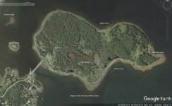
So I took this card and tried to put it on Oak Island.
When you consider that the Freemasons liked to use monuments because of their persistence to encrypt treasures (Beale Codes), I was fascinated by the thought that the blueprint of Washington DC is a secret treasure map.
We know from Oak Island that the ?stone angle? indicated a 7 degree deviation. The Washington Monument, the White House and the Capitol are drawn at perfect angles on l?Enfant's Washington DC blueprint. If you go to Google Earth and check this angle, you will see that the White House deviates from the monument by 7 degrees. Which led me to rotate the blueprint 7 degrees counterclockwise and put it on Oak Island. The following picture then appears:
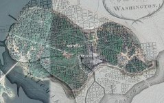
It's amazing how well the swamp, the west side, the south side, especially the corner at Smith Cove and the course of the plot of land fit on this map. Let's assume the White House, the Capitol and the Washington Monument are the 3 essential points, then I would say Samuel Ball bought exactly the right lots. I noticed two things on the map of Washington DC.
1. The Washington Monument is painted as a kind of shaft or tree stump. It's the only three-dimensional object on the map.
2. The Capitol is perfectly arranged like the Holy Grail when viewed from left to right.
It may all be a coincidence. Nobody knows why the streets in Washington DC are laid out so strangely. Maybe that's an explanation. For my part, I wouldn't look at the Money Pit site. If you measure the three points on Oak Island in feet, then the distance from the monument (entrance) to the White House is approximately 522 feet and to the Capitol approximately 1065 feet like the "La Formule Chiper". I say roughly because I don't know the scale of the map and can't make out the exact points for an accurate result. I don't think L ?Enfant wanted to draw the area between the Monument and the Capitol and therefore had problems with the Congress. Maybe that has something to do with the Oak Island treasure. I'm curious what you think of it.
When looking at the blueprint from Wikipedia, I immediately thought of the west, south, east side of Oak Island.
So I took this card and tried to put it on Oak Island.
When you consider that the Freemasons liked to use monuments because of their persistence to encrypt treasures (Beale Codes), I was fascinated by the thought that the blueprint of Washington DC is a secret treasure map.
We know from Oak Island that the ?stone angle? indicated a 7 degree deviation. The Washington Monument, the White House and the Capitol are drawn at perfect angles on l?Enfant's Washington DC blueprint. If you go to Google Earth and check this angle, you will see that the White House deviates from the monument by 7 degrees. Which led me to rotate the blueprint 7 degrees counterclockwise and put it on Oak Island. The following picture then appears:

It's amazing how well the swamp, the west side, the south side, especially the corner at Smith Cove and the course of the plot of land fit on this map. Let's assume the White House, the Capitol and the Washington Monument are the 3 essential points, then I would say Samuel Ball bought exactly the right lots. I noticed two things on the map of Washington DC.
1. The Washington Monument is painted as a kind of shaft or tree stump. It's the only three-dimensional object on the map.
2. The Capitol is perfectly arranged like the Holy Grail when viewed from left to right.
It may all be a coincidence. Nobody knows why the streets in Washington DC are laid out so strangely. Maybe that's an explanation. For my part, I wouldn't look at the Money Pit site. If you measure the three points on Oak Island in feet, then the distance from the monument (entrance) to the White House is approximately 522 feet and to the Capitol approximately 1065 feet like the "La Formule Chiper". I say roughly because I don't know the scale of the map and can't make out the exact points for an accurate result. I don't think L ?Enfant wanted to draw the area between the Monument and the Capitol and therefore had problems with the Congress. Maybe that has something to do with the Oak Island treasure. I'm curious what you think of it.


