Uwharrie River Gold, NC

ncclaymaker

Sr. Member
Aug 26, 2011
370
316
Champlain, NY on the Canadian border.
Detector(s) used
Minelab 1000, A Motorized Power Glider Trike, 17 foot travel trailer behind my Jeep. 4" suction dredge/high banker.
Primary Interest:
Prospecting
Has anyone ever tried setting up a dredge or has panned the Uwharrie River near Eldorado, NC. There are some old placer workings in the area worth investigating. I was hoping that someone has had experience with the Uwharrie River, Badin Lake or any of its' tributaries. I've heard conflicting stories about the area... tree huggers, etc.

If one looks at the google maps or Rand McNally,etc., you are led to believe that the entire area is the Uwharrie National Forest. The Feds and the State of NC would like you to believe that... but THEY are the holes in a rather large piece of swiss cheese. They own/control less than 20% of the entire forest. Check out THEIR official maps for the forest to verify it.

I highly recommend using Google Earth and installing the app from www.minecache.com. No matter what state you're in it works wonders.
 

Upvote 0
The only thing you can do in UNF is shovel and pan!You will see a few dredge's down at lower bridge on coggins mine road,but it is private land on both sides.If the gov. doesn't own the land than it is private or belong to the hunting club and posted so.The hunt club looks daily for miners.They will report you to the law ASAP,and watch your dredge and truck get taking by the law!On navigation waterway you only can boat or fish(in the boat) if own by private land on both sides.Your feet can not touch the land under the water,that is private own.The state own the water and fish only.On low water that can not support a boat,the land owners own the water and fish in it,each side to the halfway mark.
 

ncclaymaker said:
Has anyone ever tried setting up a dredge or has panned the Uwharrie River near Eldorado, NC. There are some old placer workings in the area worth investigating. I was hoping that someone has had experience with the Uwharrie River, Badin Lake or any of its' tributaries. I've heard conflicting stories about the area... tree huggers, etc.

If one looks at the google maps or Rand McNally,etc., you are led to believe that the entire area is the Uwharrie National Forest. The Feds and the State of NC would like you to believe that... but THEY are the holes in a rather large piece of swiss cheese. They own/control less than 20% of the entire forest. Check out THEIR official maps for the forest to verify it.

I highly recommend using Google Earth and installing the app from www.minecache.com. No matter what state you're in it works wonders.
I have prospected the Uwharrie and found quite a bit of fine gold from the big river. look to the smaller streams north of the river and west of hwy 109 off reservation rd. us forest service rd 576 (moccasin creek rd) and us forest service rd 544 (Mcleans creek rd)both had creek crossings with decent color. according to the forest service hq you can run a dredge in the big river as it is controlled by the state, not the forest service. forest service rd 555 (cotton place rd) has an area where you can access with a small back pack dredge. plan to clean up often, you will clog up with black sand in no time.
 

years back i heard that one dredger was driving on the highway that went through this area and got pulled over by the (police/FS???) and got cited for haveing a dredge in this "no dredge"area.....yep you gotta watch out for where your at and whos looking to cause trouble!
 

russau said:
years back i heard that one dredger was driving on the highway that went through this area and got pulled over by the (police/FS???) and got cited for haveing a dredge in this "no dredge"area.....yep you gotta watch out for where your at and whos looking to cause trouble!
I heard that there's a ton of Sasquatch in the Uwharrie, that doesn't mean it's true. The information I posted is information I gathered first hand. I personally drove to Troy and spoke with the National Forest service personnel. I also made contact with the NC fish and wildlife guys in their office in the town of Uwharrie. If you wish to verify the information I posted, please feel free to call the offices yourself.
 

Mydogisscout,,, You may want to cool your heels just a little bit. No need in being offensive on here, especially to someone that we all respect like Russau. :icon_scratch:
 

It is againts rules to dredge anywhere in UNF land. It is againts the landtrust rules to dredge at low water bridge or near. It is especially againts the rules and a big no no to dredge or used power equipment on any creeks in UNF land. If its private land its ok...but not landtrust land. That is private land yes but its leased to hunt clubs and one has to get permission(may be hard to get) just to use a pan, shovel and sluice for landtrust land. If you are dredging at low water bridge area then that is basically a federal felony and if the right people came along......loose everything, fined and possible jail time. Use of power equipment in the main forest, that will for sure at the least cost a big fine($thousands) and loose all your equipment, up to 2 years jail time as well possible.

The only place that I know of you can dredge is a few hundred yards upstream on the 109 bridge and few hundred yards downstream...

*private land is a different story, if you have access to private land then yes....but as for uwharrie national forest land, nothing but non mechanical equipment like pans, shovels and sluices. If people keep breaking these major rules, especially..you wont be able to do nothing but use your hands and a pan......I would not want to be the one that broke the camels back on that..so to speak. I just wanted to say this so people will clearly know. I am not trying to come off ass an @$$..
 

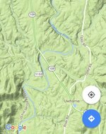
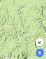
I have been to Uwharrie several times and I can't find any places to pan by the river. I would really appreciate it if somebody could give me directions for river access in the forest boundaries. I don't mind walking a ways and I'd like to know of some places close to where you could park too, I want to bring my son sometimes with me. Thanks again for any help.
 

ImageUploadedByTreasureNet.com1486944834.536876.jpg
 

ImageUploadedByTreasureNet.com1486944954.988832.jpg

Or turn in towards the 4x4 trails on the forest service rds ie 1154. Most creeks flow under those rds at some point. Moccasin creek is very popular.
 

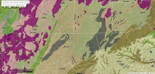
Heres a litholgy snippet of the area ! If you can see somethin that helps.

Hope the jpg is loaded. 1st time to figure it out.

johnnysau
 

Attachments

  • Uwharrie snippet.JPG
    Uwharrie snippet.JPG
    282.9 KB · Views: 430
I was planning a trip there soon since the weather has been nice. A good friend of mine has found some there. I need to ask him where he panned.
 

Top Member Reactions

Users who are viewing this thread

Back
Top