Trying to find an old structure site on a now abandoned golf course.

BABALONGOGGLES

Jr. Member
Jan 10, 2020
69
311
Eastern WA
Detector(s) used
Nokta Makro Simplex+, Bounty Hunter Tracker IV
Primary Interest:
All Treasure Hunting
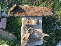
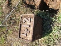
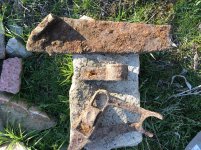
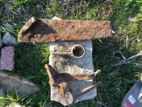
There is an abandoned golf course that was built in the late 80s. Before there was a golf course there were two other structures that were there during 1951, at least. That’s the oldest Topo map that I found. Today I hit it for a few hours trying to find deep iron. I found these all within a 3-foot radius (except the 412 box, I’m assuming that’s a golf thing). Can anyone estimate what and how old these might be? Obviously, when the golf course was built they excavated dirt, but I found these between 12-16 inches deep. Any tips searching the area would be welcome too. HH.
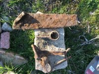
E2B2B601-50B1-41BA-BE1C-1B7895FE2C8E.jpeg
FCE9064D-8686-4C35-B65F-6C6FA9BF3081.jpeg
EF911749-380A-45C5-96E7-3A76521571D0.jpeg
 

Last edited:
Upvote 0
Higher resolution:
FB04609C-0EF1-481D-BF98-3589BD25379D.jpg
CA320BF9-3BBA-4B41-9E8E-998DD605992E.jpeg
 

Last edited:
Not sure about the other stuff, but the "412" is most likely a tee marker. They are placed on the tee box showing the distance to the green.
 

What golf course? Sundance?
 

Last edited:
If you are attempting to find the location of structures on the site prior to the golf course construction, a suggestion is to contact aerial photography companies in your area and ask if they have any stock photos taken prior to 1952.
Don.....
 

Between greens and paths, where golfers pull gloves off and drop rings, are the places to search.
 

Top Member Reactions

Users who are viewing this thread

Back
Top