TnTom
Jr. Member
- Dec 27, 2013
- 37
- 20
- Detector(s) used
- don't have one yet
- Primary Interest:
- All Treasure Hunting
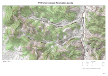
Not sure if all states provide this service I found a map site on the TVA web site that provides a really excellent mapping app that let you view like you were using Google Earth satellite and you can zoom in or out pan to any address and switch to a topo map image with labels like the names of a hollow or an old cemetery roads and elevation grids and height above sea leve., real topo maps with excellent definition. I live in a very rural hollow with 1200 - 1300' ridges on both sides of me. since I don't have a detector yet I thought I would do some ridge top exploring and these have made a great tool for recording my trail. I get the coordinates from my GPS and plot it on the topo map.
Found some great fossils and artifacts like old single point plow hardware when mules were used around her years ago. found some deer skulls, sheds, harness hardware (no gold yet but Im getting my hopes up) I was told that years ago on the north ridge about about mile down is an old community of slave cabins I havent got that far along but I hope to over the next few days see if I can find it. I did find an old cemetery graves marked crudely, dated 1800s to early 1900 latest was 1938. about 30 graves many children. Ive lived in the hollow about 15 years now and am just discovering it all over. I deer hunt but mostly not far from home like a few hundred yards and have only just now ventured to the ridge tops. Just beautiful.
These maps with my GPS and my compass will really be a help pin pointing my discoveries. Ive been told of a cave also that I'm going to find. I know of one ive have just ventured into my 20' never to the end. Im pretty closturphic but maybe I can get my nerve up when I find a partner just in case.
If you have something like the TVA see if this map service is available in your state. I'm lovin it. I went to the trader section of Treasurenet and maybe I'll find some equipment now soon.
http://tva.maps.arcgis.com/apps/OnePane/basicviewer/
Im going to attach a image of one of the maps have to figure it out temporary technical difficulty programming will return shortly! well that was easy!
I was just playing again and discovered it does the entire nation. You can type in a address like Mt. McKinley and it goes straight there and you can see the topograhy of the mountain and zoom in to read the elevation How fun! It does the whole dang world! I just looked at Pt Barrow Ak no elevation maybe because its at sea level??
Attachments
Last edited:


