gjb
Sr. Member
- Apr 21, 2016
- 281
- 333
- Detector(s) used
- Garrett Ace 300i
Garrett EuroAce
- Primary Interest:
- All Treasure Hunting
I happen to hold that it’s essentially because of human nature that it’s in the nature of treasure hunts to fail. All too frequently, it can be seen that emotions get in the way: notably greed, secrecy, impetuosity and narrow-mindedness.
I’m also tending to believe that the Oak Island mystery will never be solved due simply to personal bias. For example, were the answer published here it would just be ignored as background noise. People would simply talk over it.
Furthermore, while there are millions of Oak Island fans and aficionados who might have a view and a contribution there is only one perception that holds sway at any time: that of the owners, who are subject to their own bias. Were they given the answer they would also simply ignore it.
Potentially, there’s also a vested interest in not discovering the answer emanating from History and Prometheus (who seem not to be trying), that’s in addition to the negative agendas of gainsayers here.
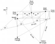
Below is a serious attempt at identifying the focal point of the Oak Island project (this not being the Money Pit). This is a reconstructed geometrical plan that explains the relationship between the locations of the Money Pit (Tree), Drilled Rocks and Triangles as found and reported.

It’s based on a Flood Tunnel running for 30 rods (495 feet) on a magnetic east-west bearing out of the Money Pit at an angle two-fifths the tangent of 30 degrees (twice the tilt of the Welling Triangle). The key feature is the naturally occurring extended rhombus with seven points marked with stars upon it, the most easterly of which is most likely the original Cave-In Pit.
These seven points appear to be highly significant, and could be the path to the answer, but at this point outright prejudice will kick in. Five of these starred points are actually the targets of the instructions on the much discredited so-called ‘Captain Kidd’ treasure maps (in reality, nothing to do with pirates or Kidd).
For most people, their innate bias will kick in immediately and prevent their reading further. Others will begin marshalling counter-arguments without bothering to assimilate what is being said.

The instructions leading to the points marked A to G in the diagram are as follows:
A: 18 NE by 71 W on Rock ... Tree
B: No Map
C: 50 Feet N by 8 Feet W on Rock ... Tree
D: 515 SE, 50 N, 36 NE, 36 NE Rocks ...
E: 18 W and By 7 E on Rock ... Tree
F: 360 yards V.R. North ... centre of triangle between Rocks ...
G: No Map.
Some will dismiss the fact that this happens without consideration on the basis that it is a figment of my own personal bias. Others will claim that this is clear proof of a hoax. None will suggest it should be investigated.
Nevertheless, this could be highly significant - maybe even a potential path to the answer to the mystery - but nobody will give a damn, because they’ll convince themselves it must be wrong without ever having seen it worked.
QED! Bias Beats All!
Explanation
All five sets of instructions are coded in the same way. Where indicated, flip the first two lines. First, take offsets from the two Drilled Rocks (or the rocks themselves if none are given) the first being from the East Rock. Next, take a third offset, starting at the Tree (the centre of the Money Pit). Form a triangle with these three points and locate its centre.
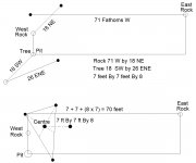
Finally, take an offset in the direction of the centre line and mid-point unless otherwise specified. This offset is in the general form ‘a By b By c’ where a and b are distances and c is a multiplier (thus, the offset is a + b + ac: so, 3 Feet by 3 Feet by Four = 18 feet). Note the British / Colonial units of measure throughout. Below is a worked example for Point A on the diagram above:

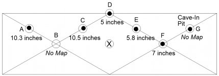
The distances from the targets of all five map points are shown in inches in the diagram below. Note well that somebody dug a hole some six feet wide and nearly twenty feet deep (the Cave-In Pit) at one of these seven map points. The centre point marked ‘X’ appears from additional evidence to be the place to look.

The fact that these derivations are so accurate (within 25cm) is a pointer to the reconstruction being correct. We’ve been handed clues, and we’re ignoring them and destroying them due to extreme bias.
The suggestion will, of course, be written off as nonsense even though a quick investigation might decide the matter either way. The true killer blow is that even if it’s right we’re powerless to act, as the owners will never listen due to their own bias!
Hence, the mystery will never be solved - and that’s entirely our fault for not taking the trouble to work it out from the clues that were so obviously left in order that someone might do just that.
If we stop thinking with bias and start thinking objectively about what Oak Island is offering us then we might just crack it, though I’m not holding my breath! It’s clearly not going to happen! Not here, anyway!
I’m also tending to believe that the Oak Island mystery will never be solved due simply to personal bias. For example, were the answer published here it would just be ignored as background noise. People would simply talk over it.
Furthermore, while there are millions of Oak Island fans and aficionados who might have a view and a contribution there is only one perception that holds sway at any time: that of the owners, who are subject to their own bias. Were they given the answer they would also simply ignore it.
Potentially, there’s also a vested interest in not discovering the answer emanating from History and Prometheus (who seem not to be trying), that’s in addition to the negative agendas of gainsayers here.
Below is a serious attempt at identifying the focal point of the Oak Island project (this not being the Money Pit). This is a reconstructed geometrical plan that explains the relationship between the locations of the Money Pit (Tree), Drilled Rocks and Triangles as found and reported.

It’s based on a Flood Tunnel running for 30 rods (495 feet) on a magnetic east-west bearing out of the Money Pit at an angle two-fifths the tangent of 30 degrees (twice the tilt of the Welling Triangle). The key feature is the naturally occurring extended rhombus with seven points marked with stars upon it, the most easterly of which is most likely the original Cave-In Pit.
These seven points appear to be highly significant, and could be the path to the answer, but at this point outright prejudice will kick in. Five of these starred points are actually the targets of the instructions on the much discredited so-called ‘Captain Kidd’ treasure maps (in reality, nothing to do with pirates or Kidd).
For most people, their innate bias will kick in immediately and prevent their reading further. Others will begin marshalling counter-arguments without bothering to assimilate what is being said.

The instructions leading to the points marked A to G in the diagram are as follows:
A: 18 NE by 71 W on Rock ... Tree
B: No Map
C: 50 Feet N by 8 Feet W on Rock ... Tree
D: 515 SE, 50 N, 36 NE, 36 NE Rocks ...
E: 18 W and By 7 E on Rock ... Tree
F: 360 yards V.R. North ... centre of triangle between Rocks ...
G: No Map.
Some will dismiss the fact that this happens without consideration on the basis that it is a figment of my own personal bias. Others will claim that this is clear proof of a hoax. None will suggest it should be investigated.
Nevertheless, this could be highly significant - maybe even a potential path to the answer to the mystery - but nobody will give a damn, because they’ll convince themselves it must be wrong without ever having seen it worked.
QED! Bias Beats All!
Explanation
All five sets of instructions are coded in the same way. Where indicated, flip the first two lines. First, take offsets from the two Drilled Rocks (or the rocks themselves if none are given) the first being from the East Rock. Next, take a third offset, starting at the Tree (the centre of the Money Pit). Form a triangle with these three points and locate its centre.
Finally, take an offset in the direction of the centre line and mid-point unless otherwise specified. This offset is in the general form ‘a By b By c’ where a and b are distances and c is a multiplier (thus, the offset is a + b + ac: so, 3 Feet by 3 Feet by Four = 18 feet). Note the British / Colonial units of measure throughout. Below is a worked example for Point A on the diagram above:

The distances from the targets of all five map points are shown in inches in the diagram below. Note well that somebody dug a hole some six feet wide and nearly twenty feet deep (the Cave-In Pit) at one of these seven map points. The centre point marked ‘X’ appears from additional evidence to be the place to look.

The fact that these derivations are so accurate (within 25cm) is a pointer to the reconstruction being correct. We’ve been handed clues, and we’re ignoring them and destroying them due to extreme bias.
The suggestion will, of course, be written off as nonsense even though a quick investigation might decide the matter either way. The true killer blow is that even if it’s right we’re powerless to act, as the owners will never listen due to their own bias!
Hence, the mystery will never be solved - and that’s entirely our fault for not taking the trouble to work it out from the clues that were so obviously left in order that someone might do just that.
If we stop thinking with bias and start thinking objectively about what Oak Island is offering us then we might just crack it, though I’m not holding my breath! It’s clearly not going to happen! Not here, anyway!


