Swift Silver Mine & Cave

Tod Ringam

Jr. Member
Nov 16, 2012
53
24
Primary Interest:
All Treasure Hunting
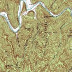
I'm fairly certain that the mine and cave is located three miles north east of Slade, Kentuky in the Red River Goarge at the head of Auxier Creek about one half mile north west of the Nada Tunnel.
Also, for what ever it's worth, this is also the location of the so called, "Great Cave of the Shawnee".
I. E., They are one and the same. There is no GC of the S per say. Tod Ringam
 

Back in the old days the general area, Auxier Branch, was called Haystack... probably because of the rock with the same name. This area has been suspect for over 100 years. Double Arch is oriented properly for the lighthouse and Courthouse Rock could certainly be thought of as a monument rock or a half moon cliff. I have hiked that area multiple times (more than a dozen) and even spent the night off trail further up that stream. There are plenty of rock houses on both sides of that drain, I am unaware of any caves or openings though, please explain?

https://www.bing.com/images/search?q=courthouse+rock,+ky&qpvt=courthouse+rock,+ky&FORM=IGRE

https://www.bing.com/images/search?q=haystack+rock,+ky&qpvt=haystack+rock,+ky&FORM=IGRE

AuxierBranchTOPO.jpg
 

Last edited:
KY Hiker,

Back in the old days the general area, Auxier Branch, was called Haystack... probably because of the rock with the same name. This area has been suspect for over 100 years. Double Arch is oriented properly for the lighthouse and Courthouse Rock could certainly be thought of as a monument rock or a half moon cliff. I have hiked that area multiple times (more than a dozen) and even spent the night off trail further up that stream. There are plenty of rock houses on both sides of that drain, I am unaware of any caves or openings though, please explain?

https://www.bing.com/images/search?q=courthouse+rock,+ky&qpvt=courthouse+rock,+ky&FORM=IGRE

https://www.bing.com/images/search?q=haystack+rock,+ky&qpvt=haystack+rock,+ky&FORM=IGRE

View attachment 1662416

KY Hiker,

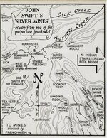
The mouth of the cave was well hidden. It should be on the west side of the branch between a red sandstone ledge and the top of the cliff. Near by, something about the cliff looks like a half moon, or half moon shape. Above the mine should be the chestnut burr rock.
If you stand on top of the ridge, above the Nada Tunnel, the head of three creeks come together. Look for a peculiar rock with marks on it. Another check; at the head of Auxier Creek, on the east side should be Indian stair steps. All so, Hay Stack Rock is in the right location according to MPH map. I hope this might help. Thanks for your time, Sam
 

Thanks for your input. The map Henson published in his book is a composite from that version of the journal and is not considered accurate by most people. I assume you speak from experience about Auxier Branch? Courthouse rock has a half moon shape to its face...There is no red sandstone on the cliffs of this drain nor Indian stair steps. There are both along Swift Camp Creek... Here is a link to a topo map centered on Nada Tunnel.

https://www.topoquest.com/map.php?l...nad27&zoom=8&map=auto&coord=d&mode=pan&size=m
 

Last edited:
I don't know what you mean by wrong? Its place on the map or ... ? That area is one of the most popular hikes in the RRG, if something were there, carvings or otherwise it would have been found. I have been in the auxier ridge area in the Fall on a weekend and saw at least 100 people day hiking. The trailhead parking is always full when the is nice weather...If something is there its really well hidden.
 

KY Hiker,

What I meant was, could the mine be close to haystack Rock? I thought I had something figured out, but that doesn't appear to be the case. I'm afraid it's got me stumped! Thanks for your interest; please forget my original post.

Tod Ringam
 

KY Hiker,

What I meant was, could the mine be close to haystack Rock? I thought I had something figured out, but that doesn't appear to be the case. I'm afraid it's got me stumped! Thanks for your interest; please forget my original post.

Tod Ringam

The map in the M.P.H. book can easily lead people to make conclusions. This legend has had folks stumped since 1788. Probably deliberately so, it may have been an elaborate goose chase to frustrate and confuse. It may be that if there was a mine, it was actually in another part of the state...who knows!! That is the fun and interest of trying to figure out the truth, or the story behind this story/legend. There has to be some factual basis for this to still be of interest to people. Good luck in your pursuit, every idea needs to be looked into that is for sure. You can travel there and have a look for yourself, or you can watch YouTube videos of others who hike the area...it really is a beautiful place to visit...and this time of year is the best time to 'see' many of the rock formations with the leaves down.

HensonMap.jpg
 

Last edited:
Just my cents prolly don't add up to 2 whole ones, but here it is: If you got an area that you think contains mines or a cache or any buried history, search it, detect it, lay eyes on every rock there. I look for what's there and love findin the carvings and seein the maps and any info, cause I love the history. I dont think Im ever gonna find signs or a map thats gonna pinpoint me to anything, even though I will keep searchin, but if there's somethin on the ground to be discovered, it's certain I'm gonna step on it or more likely trip over it.
 

Just my cents prolly don't add up to 2 whole ones, but here it is: If you got an area that you think contains mines or a cache or any buried history, search it, detect it, lay eyes on every rock there. I look for what's there and love findin the carvings and seein the maps and any info, cause I love the history. I dont think Im ever gonna find signs or a map thats gonna pinpoint me to anything, even though I will keep searchin, but if there's somethin on the ground to be discovered, it's certain I'm gonna step on it or more likely trip over it.

I agree, if I were closer (same county) as where I have interest I would be out more. It is a two hour drive for me so logistics don't allow me to comb every sqft. I'm lucky to get down there once a month for a day or two.
 

I knew and have had the pleasure of having several conversations with Dick Bond that the Portsmouth daily link mentions. Sadly he passed away not to long ago.

Just a FYI thing but Menifee County / Powell County / Wolfe County where they meet is the Red River Gorge...Clark County which is the next county West is where the Shawnee town of Eskippi____ was. I can never spell that name, also known as the Indian Old Fields. The RRGorge is 15miles North of Beattyville, KY which is along the three forks of the KY river, a crossroads of sorts for Indian Traces that run N-S and E-W. This area has always been the grand central station of Swift Silver Mine hunting grounds over the years.
 

Last edited:
I'm with Brushy ..by the way does anyone else realize this important descriptive feature...Swift never mentions crossing the creek from a certain landmark...which blows away the old map...which I agree with KY hiker...not a true representation. The not crossing the creek is key...each time I was almost certain I had found it we had to cross the creek...and it wasn't it.
 

I'm with Brushy ..by the way does anyone else realize this important descriptive feature...Swift never mentions crossing the creek from a certain landmark...which blows away the old map...which I agree with KY hiker...not a true representation. The not crossing the creek is key...each time I was almost certain I had found it we had to cross the creek...and it wasn't it.

I've noticed a lot about the descriptions, but hadn't picked that up. Hadn't reread any of them in a while though. Will have to now though.
 

I'm with Brushy ..by the way does anyone else realize this important descriptive feature...Swift never mentions crossing the creek from a certain landmark...which blows away the old map...which I agree with KY hiker...not a true representation. The not crossing the creek is key...each time I was almost certain I had found it we had to cross the creek...and it wasn't it.

This is why Curtis needs to show up on here more often, gives us all a good sense of direction and clear insight! Someone needs to check on Boomer if they have contact info, not seen him since early Oct. or maybe Sept.

...the only thing I can remember about crossing a creek was the rock bridge? And I am not certain if that is in all the versions I have or read.
 

Last edited:
I know it's quite a distance away but what does everyone think about the cache Bill found in Pigeon Water Cave. I know I've heard it's part of the swift cache, Shawnee cache, and Sol Mullins all. I've been going to the cave since I was a kid and the area does resemble some of the swift tales like the great ridge, but lots of places in the state have great ridges lol.

Merry Christmas to all you guys!!!

I think Bill Gibson found the 'Great Cave' or the 'Shawnee Cave' and the stash of Swift. He said it was 7 miles in from where he went in, but as he said it might not be that far from another entrance. My guess is, the way Swift went in has either caved in or was made hidden by them to protect it. Mr. Gibson most likely stumbled across it by accident...but what a find he had!

http://www.treasurenet.com/forums/l...hers-give-presentation-swift-near-breaks.html
 

Last edited:
I know it's quite a distance away but what does everyone think about the cache Bill found in Pigeon Water Cave. I know I've heard it's part of the swift cache, Shawnee cache, and Sol Mullins all. I've been going to the cave since I was a kid and the area does resemble some of the swift tales like the great ridge, but lots of places in the state have great ridges lol.

Merry Christmas to all you guys!!!

There are so many stories of counterfiters of coins and the untold stories of them, it's likely no one will ever know. Bill had a great find but I doubt it was Swifts. I would lean to think more along the lines of it being Mullins cache, given the area where he found it. Just my thinking.
 

Top Member Reactions

Users who are viewing this thread

Back
Top