Strange story.

Crow

Silver Member
Jan 28, 2005
3,756
10,432
In a tax haven some where
Detector(s) used
ONES THAT GO BEEP! :-)
Primary Interest:
Other
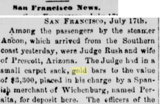
Greetings all. Not quite sure where this all fits. The followings news article.

perata.JPG


Why would a judge from Prescott Arizona be carrying a merchants gold for especially one by the name Peralta? That would in 1876 price equate to 379,842 in today's prices.

Crow
 

Attachments

  • 1722331254127.png
    1722331254127.png
    41.6 KB · Views: 16
Greetings all. Not quite sure where this all fits. The followings news article.

View attachment 2161424

Why would a judge from Prescott Arizona be carrying a merchants gold for especially one by the name Peralta? That would in 1876 price equate to 379,842 in today's prices.

Crow

Crow: The name of that Arizona burg is spelled "Wickenburg" today. The state re-routed the highway to bypass the center of town over a decade ago, and the downtown dried up from a lack of business.

The famous Vulture Mine is just outside of town. And there is quite a story about the "Wickenburg Massacre" stage coach robbery.

Good luck to all,

The Old Bookaroo
 

Here is some more information on the Grijalvas gold mine. It was quite rich in its day.
mine 5.JPG
mine 4.JPG


mine 3.JPG


Here is plan of mine below.

mine 1.JPG

I do not know the current status of the mine. More investigation deeper in surrounding areas may reveal other interesting possibility. Anything to north east as fault are trending to north east of Wickenburg. Vuture mine was south of Wickenburg.

Much of the active placer gold mining in Arizona is around the town of Wickenburg. Areas of high gold potential are located north of Wickenburg in Yavapai county, and south-southwest in Maricopa county.

The area north of Wickenburg is the location of the Black Rock district. This area is known for lode mining, but it still has one of the highest concentrations of placer mining claims in the state. Township 14 0080N 0050W ranks 8th in the state with 118 claims and 14 0080N 0040W ranks 20th with 47 claims.

These Black Rock district townships are directly south of the townships identified in the Weaver Rich Hill district description.

Crow
 

Last edited:
Based on the three samples taken the average 4 ounces of gold per ton and 30 ounces per ton silver. In the mine site. No comprehensive drilling program ascertain the size of the ore body.

Samples alone can be misleading.

Here is same below from vulture mine south of Wickenburg.

gold from the vulture mine.JPG


The first sample shows gold with over base metals copper and sliver. The quartz shows free gold.

In some cases the prescience of free gold in quartz can be spectacular. Here is a picture below.

gold.JPG


It makes you wonder how many quartz reef are still out there north east of Wickenburg and to the south.

The epithermal vein deposit (EVP) is a type of mineral deposit that forms in the shallow subsurface, typically at depths of less than 1,500 meters below the Earth's surface. These deposits are formed by hot, mineral-rich fluids that circulate through fractures and cracks in rocks.

They can be very rich concentrations in a small area. Making samples very rich. like the samples from the vulture mine and from the Grijalvas gold mine. endless to say much of the host rock around is usually barren except where there are fractures.

I would not be surprised even the waste tailings could be reprocessed for gold recovery at these sites. As modern techology has improved v astly recovery methods.

Both mines are epithermal in origin. Both types of deposits are hydrothermal in origin; high-temperature (700-350 °C) porphyry deposits generally form at depths between 2 and 10 km from predominantly magmatic fluids, while low-temperature (ca. 300-150 °C) epithermal deposits form at depths <1.5 km from mixtures of magmatic and meteoric fluids.

Low-sulfidation system mostly occurs in the environment of near neutral pH state and high-sulfidation system occupies in the environment mostly proximal to the porphyry stem. Here is basic diagram below.

Epithermal Systems (The association of gold mineralization with volcanic)-geology in.JPG

For anyone wanting research further the picture above gives you an idea what to look for. In finding new deposits and old worked out ones. There is potential to the gullies and mine in region mine tailings to yield gold. even for the most basic of treasure seeker, in region northeast and south of wickenburg.

Crow
 

Last edited:
Interesting enough Pedro Zarilla Grijalva full name Pedro Zarilla Grijalva Parata.

pedro.jpg


Some times we have in records was refereed to as Pete. And in the newspapers. There is discrepancy on the his death two dates 1910 and 1916. I suspect the correct date was 1916.

His badly weathered head stone below is recorded as Pedro Zarilla Grijalva Parata. in a cemetery in Wickenburg.

Pedro was married twice first wife died in 1895 and remarried in 1897. He had many children son and daughters.

IN 1900 census he was listed as a miner. below.
pedo miner 1900.JPG

What we can gather he still had contoll of the mine by then.

The Grijalva Gold Mine is located in the Black Rock-Blue Tank Mining District near Wickenburg, Arizona. This region is now designated as part of the Hassayampa River Canyon Wilderness.

The mine was initially discovered in 1895 by Pedro Zarilla, also known as Grijalva. Although currently closed with no plans for reopening, the Grijalva Gold Mine was operational from 1908 to 1936.

It was considered a small-scale production mine during its active years. The mining operations primarily involved underground workings, with a single known shaft. The mine reached a maximum subsurface depth of 46 meters (150 feet) and had a total length of 244 meters (800 feet). The ore body at the Grijalva Gold Mine is described as tabular in shape, measuring 97 meters (320 feet) in length, 45 meters (150 feet) in width, and 1 meter (6 feet) in thickness.

mine 2.JPG

Gneiss, a type of metamorphic rock, is prevalent in the host rock formations in this area. The surrounding area is characterized by the Mexican Highland of the Intermontane Plateaus, which contributes to the geomorphology of the region. Pedro only worked the outcrop on surface.

By 1905 Pedro no longer owned the mine. There was four later owners. A man called Beale 1905 took over then a company was formed the Grijalva Nueva Mining Company. Who drove tunnels and addicts between 1905 and 1932 Kahor & Company. The mine was always a small time operation. finally in Roy Marks took over working tailings and alluvial deposits.

The mine operations inside the tunnels was well and truly ceased by the 1930. A collapse created a glory hole in the upper workings.

The ore body Length: Width: 45.72 meters (150.00 feet) Bottom Depth: 45.72 meters (150.00 feet) Thickness: 1.83 meters (6.00 feet) Strike: north 20 east Dip: near vertical.

To day its part of an active lease as of 2020. own by Laura and David Lamb yet it seems the owner of mining lease has no interest in the old mine workings are more content to potter around picking over the tailings.

Surprisingly the new shaft was never completed as it is possible if they excavated deeper the two near vertical of gold bearing ore described as columns of broad flat slabs, would intersect converging on each other. For that to happen the upper tailing pile of mine waste needs to be moved. and various other safety issues need to addressed with glory hole that has collapsed into number and number 2 tunnel.

Sadly some of things needed to be done is out of the scope of week end hobbyist.

Crow
 

Last edited:

Top Member Reactions

Users who are viewing this thread

Back
Top