Starting My Own Thread for This. Homestead Site East Of Queanna

VonDigger

Jr. Member
Dec 13, 2009
88
61
Baden, PA
Detector(s) used
Bounty Hunter Lone Star
Primary Interest:
All Treasure Hunting
Many of us know about what Finders Keepers posted about the Indian Stonehenge. Well I decided to go up there and start from scratch and see what I make of it. This was the preliminary trip. I am not trying to discredit anyone by doing this either. But just on this trip, I am leaning towards homestead. I only had a limited amount of time to be there this time as well (2 hours). So just did a general sweep. The next trips, when I can get up there will be done working out from a central location to get a good canvas of the area. I do have some pictures so I will post those here. Also, once I get the next date I will go up there (I live 180 miles from it), I post that information as well.

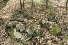
Picture one is just one of the stone "fences" or rock mound that more than likely outlined a field or marked property boundaries.

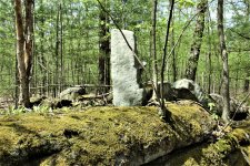
Picture 2 is interesting since this looks like the stone was arranged and not just tossed into a pile. This will get some time devoted to it once I get back. I might be something, then again, maybe nothing.

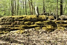
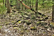
Pictures 3 and 4 I believe is a corner marker for a property.
IMG_2448 (2).JPGIMG_2455 (2).JPGIMG_2498 (2).JPGIMG_2500 (2).JPG
 

yeah after i went up there my conclusion is most likey old farm. even researched back to what i think are origional settlers. they even cursed the land and the guy who brought them there it was so rocky haha. the way they described the rocks as being spilled across the land as if falling out of some gods aperon, made me think of glacial action. there was someone up there doing stone cutting though. the stone chimny down hill of the outcrop leads me to belives it was not ancient stone cutting
 

also not a corner marker. the size is of the size used in chimney. just a left over that someone recently stood up
 

also not a corner marker. the size is of the size used in chimney. just a left over that someone recently stood up

What made me think corner marker is that stone was standing on a natural stone formation. There are a couple other pictures I want to look at closer around those rocks that might be something, then again, could be something else.
 

the round stone piles are the only thing that confuse me. there is a field clearing method that was tossing stones into piles are far as you could throw easily by hand picking. but some of those round piles were clearly stacked. a few would need to be escavated to find out if they are burial mounds like finders claims. or if they were simply stacked around trees?or stacked so as you could get the piles to have smaller foot print.
 

What made me think corner marker is that stone was standing on a natural stone formation. There are a couple other pictures I want to look at closer around those rocks that might be something, then again, could be something else.

look at stone chimney and old maps. not a corner marker as far as i can tell. especially with the many other similar cut and sized rocks laying around.
 

also look at the mineralization on the rocks from where the rocks were cut from the natural cracks in the outcrops. this is just evidence of stone cutting taking place here.
 

also look at the mineralization on the rocks from where the rocks were cut from the natural cracks in the outcrops. this is just evidence of stone cutting taking place here.

Good point and I will keep an eye out for that. Probably later on tonight, I'm going to share what my "More of Gods Country" map has to say about that area. The mounds are mentioned, but also around that same area were ruins of a couple industries as well.
 

Top Member Reactions

Users who are viewing this thread

Back
Top