Speaking of Covid

Interesting. It makes sense. When Europeans first arrived, they utilized established pathways thousands of years old. Their paths became our paths, then roads, highways, railroads. They intersected in the same places. Native people, laid out our highways and city locations long ago.
 

Very good points for both of you. Kray, you are right about the old trails becoming the superhighways. One place here in the county the Spanish were supposed to have landed in the 1500's and moved inland to a place called "Priest's Ford". There some of the Spanish missionaries were killed by the Indians, and after that they moved out of the (Chesapeake) Bay. Along the side of one state road, on a tiny hillock we found a set of three musket balls and a 16th century 1/2 blanca mangled Spanish coin dating to about the time the Spaniards had come here. It was 10' off the side of the modern road!
 

Interesting. It makes sense. When Europeans first arrived, they utilized established pathways thousands of years old. Their paths became our paths, then roads, highways, railroads. They intersected in the same places. Native people, laid out our highways and city locations long ago.

I suppose rivers and streams generally followed the same courses. I'm on the west coast where human activity has always been sparse. Many times, I ponder how many times I'm the first human to step foot on a particular square foot of land. It's interesting to think about.
 

I think it's well known that places populated then and now are similar due to geography, waterways, resources, etc...

But it also stands to reason that the places with a higher population density today would be not only having higher incidences in Covid but also more frequent looks at the ground.
So it may not just be that we are living in the same spots Clovis people lived but rather that the places we now live in are the places we hunt and therefore the rate of found fluted pieces is higher in those spots.
 

But it also stands to reason that the places with a higher population density today would be not only having higher incidences in Covid but also more frequent looks at the ground.

Replace "ground" with "sidewalk." Not many Clovis artifacts found in downtown Pittsburgh . . .
 

Replace "ground" with "sidewalk." Not many Clovis artifacts found in downtown Pittsburgh . . .


The same could be said about most any major metropolitan area now. But they were once made up of ground that was turned over many times over many years. The more exposures and more eyeballs a habitation site has on it the more objects should be found. But I'm sure you, of all people, know that.
https://www.wesa.fm/post/who-lived-here-first-look-pittsburgh-s-native-american-history#stream/0
 

Replace "ground" with "sidewalk." Not many Clovis artifacts found in downtown Pittsburgh . . .

Just as I can’t imagine hunting a field, many on here likely can’t imagine life without them. I’m sure most all the best sites are under asphalt here in suburban Boston, and those remaining thoroughly picked over. Add in the sites under the ocean, and we are likely missing the most populated sites around here.
 

I think it's well known that places populated then and now are similar due to geography, waterways, resources, etc...

But it also stands to reason that the places with a higher population density today would be not only having higher incidences in Covid but also more frequent looks at the ground.
So it may not just be that we are living in the same spots Clovis people lived but rather that the places we now live in are the places we hunt and therefore the rate of found fluted pieces is higher in those spots.

I suspect that there isn't a uniform blanket of Clovis artifacts, spread across the land, mainly found where the most people are looking at the ground. The OP was demonstrating how the Clovis people, lived more densely in the same areas that we live closely in higher populations today.
 

From the article.....
CREDIT TO: CRAIG CHILDS

(not saying anything one way or the other, just thought it was interesting)

9792C275-798D-4887-9949-F22391B55261.jpeg

“Not long ago, a friend who lives nearby, a skilled hunter of arrowheads, found a beautiful fluted spear point. It came from between his house and mine, along a ditch. The find was stunning, what I think has to be Clovis technology from 13,000 years ago, its point as sharp as the day it was made. I’ve held it in my hand, turning it over and over, one of the finer pieces of stonework I’ve seen. He found it, oddly, while picking up trash along a rural ditch. He figured it had to have been dredged up during modern history, dumped to the side, out of place, no known provenience, showing up here out of the blue. Maybe not entirely out of the blue, though, this point is part of a much bigger puzzle.

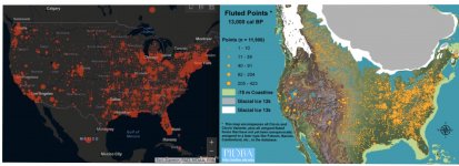
A week ago I snapped a shot of the coronavirus map for North America. This was before red dots merged and turned the US into a record breaking blot. Next to it, I placed a map of fluted projectile points from the Ice Age, dating to about 13,000 years ago. The two maps struck me as remarkably similar. What might be behind this?

Our modern gatherings and zones of interaction appear to have not changed much since the Ice Age. The same old passages are still open. Where people go, Clovis points and viruses follow.

In both cases, the East — which was heavy in mastodons back in the day — is the epicenter. The West, geographically and climatically more complex, prone to scattered communities, is lightly peppered with Ice Age artifacts till you get to the coast. If this map included stemmed points (as opposed to fluted), it would give us the coastal concentration we see on the viral map.

Some scholars have suggested the Ice Age map suffers from bias, saying that more artifacts tend to be found where more people currently live. But 90 percent of documented fluted points are from east of the Mississippi. That’s more than a bias. That side of the continent saw a cultural, technological outbreak in the late Pleistocene.

Florida seems to be one of the exceptions to these two maps. It goes blank in the Ice Age when this thumb of a state was one of the largest concentrations of dire wolves and sabertooth cats in the Americas. It was the North American savannah, and also the first place on this hemisphere where humans were proven to have co-existed with Pleistocene megafauna, discovered in 1915 on the Atlantic side where bones of 14,000-year-old people were found in the same layers as one-ton armadillos and bison twice the size of our own. People were likely all over this peninsula, but half of Ice Age Florida is now underwater and the rest has been a flux of shorelines and marshes. Fluted points showed up here early and stayed for thousands of years, suggesting Florida should be as bright with late Pleistocene activity as it is with registered cases of Covid-19.

We are still obedient to the lay of the land. Some places always see more human flare-ups. It’s not a new idea. Archaeologists thrive off the notion that we’ve been doing the same things in the same locations for most of human history. North America is a chess board, its pieces moved into familiar positions. Where do the big rivers flow? Where are coastlines protected, where do passes lead through mountain ranges?

Southern Arizona, thousands of years ago, was the site of a Neolithic-age irrigation society, an early Native American hydraulic empire of cotton and corn watered by more than a thousand miles of canals and ditches, which modern Phoenix built upon like a blueprint. Ten thousand years before that, it was a subtropical Ice Age paradise where numerous mammoth kills have been unearthed, revealing one of the larger Clovis occupations in the West, now a red-dot cluster of Covid-19.

People 13,000 years ago gathered on the Front Range of Colorado like a wave hitting the Rockies: Denver, Fort Collins, and Colorado Springs. Either side of the Appalachians looks like a bomb went off, which it did, culturally, the highest concentration of Clovis technology appearing in Tennessee and along the East Coast. The oldest known large gathering in North American history, the Bull Brook site from 11,000 years ago — a caribou processing and tool-making center that saw up to several hundred people — is in Ipswich, Massachusetts. The stones brought there for manufacture came from, on average, 300 miles away. People were moving, carrying themselves and their goods long distances, coming together in groups, a plan for how people have done it ever since.

Clovis tools and weaponry — bullet-shaped projectiles made of glass-like stone masterfully thinned — was one of the fastest moving technologies in the Ice Age. While the same old points were being used for 10,000 years or more, Clovis spread like wildfire, estimated to have broadcast across North America in 200 years. You might call it viral. In short order, the same unique point was being made in Delaware and California. It wasn’t long before fluted points reached Alaska and the tip of South America. It’s something our species does well: spread and remain connected.

During this pandemic, one solace I personally take is that my family and I live in the Intermountain West, where both maps are emptier. I’m hours from the nearest interstate, the closest town just over 500 people. I prefer living away from the action. The archaeological sites I know around here don’t have fluted points. An archaeologist worked for years on a cave not far from where I live in western Colorado, where he took occupation dates back to 13,000 years ago. Almost proudly he says he didn’t find diagnostic weaponry at the site, no Clovis technology. All they found were cooked rabbit bones and deer, people eating grass seeds and hammering rocks into tools. These were utilitarian folks living in the middle of nowhere, far from the Ice Age hustle and bustle.

There is no getting away from ourselves. The county next to mine has 39 Covid-19 cases as of now. My county is at 11. My friend found the Clovis point just a couple miles from my home. He picked up a tool from 13,000 years ago, a reminder that no matter how far we go, we are bound together. The finest threads connect us, make us the same.”
 

Last edited:
Just as I can’t imagine hunting a field, many on here likely can’t imagine life without them. I’m sure most all the best sites are under asphalt here in suburban Boston, and those remaining thoroughly picked over. Add in the sites under the ocean, and we are likely missing the most populated sites around here.

The shallower submerged coastal areas are probably a treasure chest of artifacts. As will be our coast lines if Al Gore’s overdue prediction for the end of mankind eventually comes true.
 

Last edited:
I suspect that there isn't a uniform blanket of Clovis artifacts, spread across the land, mainly found where the most people are looking at the ground. The OP was demonstrating how the Clovis people, lived more densely in the same areas that we live closely in higher populations today.

"I think it's well known that places populated then and now are similar due to geography, waterways, resources, etc..."
 

A lot of great points made here. (Pun intended.)

Yes, areas that were great for habitation back in prehistoric time tended to be good for habitation into historic period, and then once there was a population mass, it was more easily sustained through the industrial revolution.

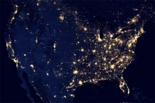
That said, if you compare a picture of the US at night, you could make the case that it looks similar to the Covid map, as well as the Fluted Point Database map. Long story short, I think the population density, 200-300 years of agriculture vs 100 years or less of ranching and some farming, and some geological factors (wind blown deposits), skew the map to show more fluted point makers in the Eastern part of the US. What the map shows is that more fluted points have been found in the East, there might be 10 times as many out in the vastness of the American and Canadian West but they just haven't been found and documented.

Night Map.jpg

Growing up in Indiana it wasn't uncommon to have 4 or 5 other hunters out on the same site after a field was plowed and had a decent wash down. Digging at known sites you might have a traffic jam of people over a long weekend. You'd bump into the same people at auctions and shows, and there was one just about once a month within an hour or so drive. Out West, I know Great Basin hunters who had never met another collector until they started meeting them forums.)
 

Not much, thinking about going to Sherwin Williams for some trim paint tomorrow, you?
missed my opportunity to paint...freezing temperatures make paint peel.
 

A lot of great points made here. (Pun intended.)

Yes, areas that were great for habitation back in prehistoric time tended to be good for habitation into historic period, and then once there was a population mass, it was more easily sustained through the industrial revolution.

That said, if you compare a picture of the US at night, you could make the case that it looks similar to the Covid map, as well as the Fluted Point Database map. Long story short, I think the population density, 200-300 years of agriculture vs 100 years or less of ranching and some farming, and some geological factors (wind blown deposits), skew the map to show more fluted point makers in the Eastern part of the US. What the map shows is that more fluted points have been found in the East, there might be 10 times as many out in the vastness of the American and Canadian West but they just haven't been found and documented.

View attachment 1875732

Growing up in Indiana it wasn't uncommon to have 4 or 5 other hunters out on the same site after a field was plowed and had a decent wash down. Digging at known sites you might have a traffic jam of people over a long weekend. You'd bump into the same people at auctions and shows, and there was one just about once a month within an hour or so drive. Out West, I know Great Basin hunters who had never met another collector until they started meeting them forums.)

I think the eastern part of our country simply has a longer richer history of human habitation.
Supposedly the west coast should have the oldest stuff since the tribes are said to have first roamed down from Alaska. You just don’t see people finding lots of really old stuff here like you do back east.

Maybe it was the darn grizzly bears, wolves, and lions that kept most people away from the west coast.

I think the article was really just someone musing out loud about things more than it was a scientific theory.
 

There IS an interesting theory that fits the known facts and gives the orthodox establishment fits playing out on (website) the cosmic tusk: comet-related epidemics. A connection known and written about from deep antiquity on down but laughed at and ignored today because it disrupts the paradigm. Curious the way most serious covid infection happened in a fairly narrow band circling the earth (known comet trail) and begins quickly after a detached piece of it was documented to have hit the ground not far from the bioweapons lab there.

I can't read the stuff myself because every time I access it on my old tablet the page reboots. Also curious, that.

FWIW
 

Last edited:

Top Member Reactions

Users who are viewing this thread

Back
Top