squirrelcop
Greenie
I wish I could go check these sites, but if I can't, I hope someone can.
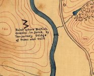
I was looking for civil war railroad maps and I stumbled across this "Reconnaissance map" that is truly fascinating! It shows numerous emplacments and batterys that are on private land. Most interesting to me was the location marked: "Point where British crossed, in force, by temporary bridge of trees and rails"
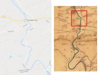
I believe that this location is here:
39°52'19.3"N 75°35'46.9"W
https://www.google.com/maps/place/3...x0!7e2!8m2!3d39.8720231!4d-75.5963524!5m1!1e4


I think this area would pour out revolutionary war artifacts!
The original map:
https://www.loc.gov/resource/g3822b.cw0320600/?r=0.148,1.233,0.755,0.38,0
I was looking for civil war railroad maps and I stumbled across this "Reconnaissance map" that is truly fascinating! It shows numerous emplacments and batterys that are on private land. Most interesting to me was the location marked: "Point where British crossed, in force, by temporary bridge of trees and rails"
I believe that this location is here:
39°52'19.3"N 75°35'46.9"W
https://www.google.com/maps/place/3...x0!7e2!8m2!3d39.8720231!4d-75.5963524!5m1!1e4


I think this area would pour out revolutionary war artifacts!
The original map:
https://www.loc.gov/resource/g3822b.cw0320600/?r=0.148,1.233,0.755,0.38,0


