Some Volcanic Rocks

Cariboo5

Hero Member
Oct 27, 2011
766
1,262
Primary Interest:
All Treasure Hunting
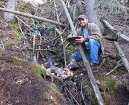
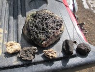
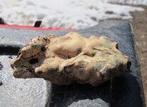
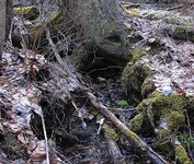
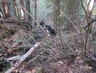
My son, Nugget ( my lab & collie cross) and I went to a spot where there is huge basalt boulders (possibly a glacier moraine). While there we heard a trickle of water so we went to investigate. Found a tiny trickle of a stream on a fairly steep hill side. Another surprise where the little pools of pumice and volcanic rocks we found. The first picture is where the trickle of water comes from under the stump (under ground spring), also pictures of nugget & my son, a garter snake that nugget found and finally the rocks...Turned out to be a good day......
Pumice 1.JPGPumice 2.JPGPumice 3.JPGPumice 4.JPGPumice 5.JPGPumice 6.JPG
 

...that volcanic rock sure looks familiar! lol Nice pictures also.....better start looking for agate there maybe? You know that old saying..."where there's volcanic rock & water, there's agate"....oh, guess that's my old saying.:laughing7:
 

Upvote 0
Sounds like a wonderful day! The pics are great.

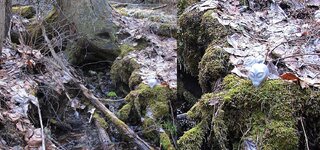
It was mamabear thanks. By chance did you happen to spot Vultar in the first picture. He's a stone figure (Botswana agate) that I always include in at least one picture. On one of the claims there is a large depression which people told me jokingly is an alien landing site, so for fun I got this alien face and named him Vultar. He's now a good luck mascot and is some where in the pictures...

Vultar Close 2.jpg
 

Upvote 0
...:alien:....lol...cute idea Cariboo...will look for him from now on! Have you ever posted a picture of the "depression"?
 

Upvote 0
...:alien:....lol...cute idea Cariboo...will look for him from now on! Have you ever posted a picture of the "depression"?

Thanks CK.....Vultar will be some where in a picture or two. Yes to your question on the depression pictures. I still have about 3 weeks before I'm able to see it for the first time and the ground view will be completely different from some of these pictures as erosion, plant & tree growth etc. will change the land scape and some times pictures can be deceiving. I will have to reserve judgement for later this summer, however I will be looking for all the indicators..

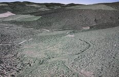
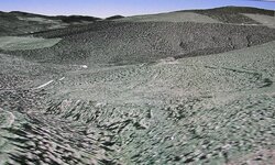
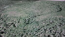
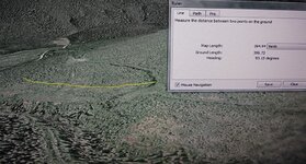
I would like to hear your opinions on the following pictures taken from Google Earth...Thanks..This is not any known mining or logging activity that I am aware of..

CR 1.JPG...CR 2.JPG...CR 4.JPG...CR 4.JPG...CR 5.JPG
 

Upvote 0
What you are looking at is a landslide. The earth has shifted down hill from the base of the arc further up the hill and the land has shifted out into the valley below. If you look closely you can see how the base of the slide has altered the pattern of the valley it slid into. What I mean is to compare the slide side of the valley to the far side and notice how the slopes of both meet at a higher point than the original valley viewed in the foreground of your images.

If you are visiting this place you should be able to confirm this by going up hill to the break point of the slide and there you'll probably be able to see the layering of the valley. I expect you wont find much old vegetation along the break either and a lot of exposed roots.
Be nice to know if I'm right ;)
 

Upvote 0
DDancer thanks for your thoughts. Having the advantage of viewing this at all different angles I am so close to 100% certain it is not a land slide. This is bowl shaped and on the down hill side the slope remains a normal gentle slope except in the area of the creek (left side) which has a rather steep side up about 40 yards from the creek.. There also appears to be a smaller bowl (depression with sloping sides both in and out ) within the larger bowl in this depression...

I will be spending a fair bit of time on these new claims for the required exploration work and by the end of the summer or early fall I will have a better idea what it is. I'm not going to completely rule out your land slide idea and will let you know as I am looking forward to see if I can determine what this really is....whether a land slide, impact crater, thrust or alien landing site...Again thanks for your input..
 

Upvote 0
I believe that it is too shallow for an impact crater and there should be a deeper depression towards the center if that's what it is. The landslide theory is a possibility but it appears to be more of a collapse from underneath as in a large cave collapse. However, if that is somewhat of a road coming into the circular area from almost the top middle of pic #1 and traveling Southwest if you consider the top of the pic as North and the bottom of the pic as South, then it is possibly man made. If so, then it is possible that it is an old test Surface Pit and they were testing for Gold and viability for mining.


Frank
 

Upvote 0
Surface test pit is a very good possibility Frank...The old maps show 3 pits which would be on the west side on picture #1 however goggle earth does not show them. As you mentioned that is an old road / skidder trail for logging that out lines the rim. This is where the metal detector will be a very important tool if one can find evidence of old mining etc. which would confirm what this could be. Good point & thanks Frank....
 

Upvote 0
...Wow Cariboo, that depression is big & very interesting, thanks for posting the photos. My first thoughts when seeing it was either an old impact carter or maybe a collapse from very old volcanic activity, of course I don't know, just interesting to imagine what. But....we can't rule out the landing site thing....lol...you never know...after all there is " Vultar"! :) I say this kind'a kidding....I did once actually witness (along with my dad & brother) a "craft" that flew in a zig-zag pattern with actually stops in mid air....along with amazing speed. Even saw it up close...well, I think the guys probably know more about what the depression is than I, but thanks for giving us something to ponder on....and yes, keep us up-dated on it please....
 

Upvote 0
Hehh, alien landing site..... oh my :) Don't get me wrong I do find that thought honestly amusing but wonders will never cease to amaze! LOL

Anyrate, *breathes* on a more sober note, I don't really get the impression that the site may be of extraterrestrial origin *ie a crater* due to the irregularities inside the bowl and how the up slope lip is formed. But who knows a tangential strike could knock a divot in the earth like that. *shrugs* The features just are not consistent in my view.

A mining pit, even a really old one, should show more signs of tailing piles. There are some interesting features that could remotely be tailing piles but I am drawn to how the surface features on the surrounding land as compared to the features inside the depression are pretty much identical. For such a large depression to have been dug would not have the internal features been altered a lot more?

Well those are my arguments. This is a fun thread. I'll add one more bit to my slide hypothesis. Not all earth movements have to be drastic :)

land slide demographic.jpg
 

Upvote 0
""...Wow Cariboo, that depression is big & very interesting, thanks for posting the photos. My first thoughts when seeing it was either an old impact carter or maybe a collapse from very old volcanic activity, of course I don't know, just interesting to imagine what. But....we can't rule out the landing site thing....lol...you never know...after all there is " Vultar"!
smiley.gif
I say this kind'a kidding....""


It certainly is CK, rough Goggle measurements are 399 yards x 374 yards and on the top side hill to bottom center is 190 yards. Big enough that when on the ground one would probably not even know this is bowl shaped...

I enjoy you're kidding around, a sense of humor and a good chuckle does wonders....

In the end it is what it is and I am really looking forward to spending a lot of time there trying to find out,....After all "there is Vultar"......
 

Upvote 0
Hehh, alien landing site..... oh my :) Don't get me wrong I do find that thought honestly amusing but wonders will never cease to amaze! LOL

Anyrate, *breathes* on a more sober note, I don't really get the impression that the site may be of extraterrestrial origin *ie a crater* due to the irregularities inside the bowl and how the up slope lip is formed. But who knows a tangential strike could knock a divot in the earth like that. *shrugs* The features just are not consistent in my view.

A mining pit, even a really old one, should show more signs of tailing piles. There are some interesting features that could remotely be tailing piles but I am drawn to how the surface features on the surrounding land as compared to the features inside the depression are pretty much identical. For such a large depression to have been dug would not have the internal features been altered a lot more?

Well those are my arguments. This is a fun thread. I'll add one more bit to my slide hypothesis. Not all earth movements have to be drastic :)

View attachment 983793


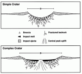
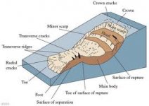
I'm glad you mentioned this is a "fun post" as it is and should be kept that way. When I first viewed the new claims on Goggle earth and seen this my very first impression was "looks like a crater". Reason is that this appears to be more circle shaped. In researching craters I found that there are simple ones and complex ones (picture attached)....All I know it does not look normal for the area..

Keep those arguments coming as I am storing every one's comments on the back burner for the simple reason that when I'm finally out there I can relate the comments to what I see in the field which is a plus in my book. I was determined to start with but man now I really feel committed with all the input to resolve this with hopefully a positive ending..I will post pictures for further comments through out the spring & summer...

Complex crater.gif
 

Upvote 0
....:laughing7:...funny Cariboo :thumbsup: Can't wait to maybe hear what made the depression, maybe check to see if radioactive or if any magnetic rock there. Yes, agree with DDancer..... this post is enjoyable! :)
 

Upvote 0
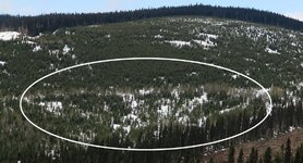
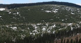
Update:....Still 3 to 4 feet of snow in the bush so probably not until June will I be able to see this dip up close. Here's a distance shot from about as high as I could get that shows the hill side and the oval shaped dip.
Two pictures, one of the hill side and the second with the dip circled.. On both the left and right sides it appears both are sloping down and inward, from the top ridge it is sloping down wards and it looks like on the bottom ridge some of the trees are taller than those in the middle of the dip...At this point I am still not 100% certain what this may or may not be..??

Thoughts...??


Dip 22.JPG.......Dip 22 Circled.JPG
 

Upvote 0
I'll keep my bet on a slide ;) The crater idea is nice however the structure still points towards a land subsidence. Your new view has good elevation and changes the previous view by 90 degree's in my opinion. Overall its a funnel looking event consistent with a valley slide. I'm noting the elevated ridge in the left foreground as its showing a minor break with the main slide in the background. Add to that the right background ridge and its shallower break all are pointing towards a shift in the middle. In the previous view the same shifting can be noticed however your new view only confirms my previous hypothesis. Hope the snow melts soon :thumbsup:
 

Upvote 0
So that's your story and your sticking to it.....Cool DDancer...:thumbsup:.....I think I see what looks like an out side perimeter but only time will tell when on site on ground....

Attached is a another picture for comparison (tried to line up the picture and the google earth view as close as possible...).. All ideas welcome....


The Dip X2.jpg
 

Upvote 0
Hi Cariboo...nice to have an update. Sure is interesting, sorry I can't help but I can watch.:laughing7:....will be keeping an eye on it, good luck! Oh and nice pictures to!
 

Upvote 0
From DDancer:..."Hope the snow melts soon
thumbsup.gif
"...


I couldn't agree more with you and I'm hoping myself also......My son, Nugget and I hiked in over a mile to the top of the mountain pass where the last claim is and we were standing on 3 - 4 feet of snow still.

Interesting thing on the last claim here is it looks like it may be on a divide where the water flow is flowing in two directions down hill on either side, and the trees are spaced out giving a park like appearance...


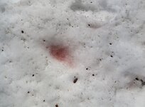
Walked by a patch of Water melon snow ( a species of green algae containing a secondary red carotenoid pigment )....picture attached.

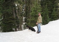
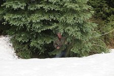
Both black & grizzly bears are out here so we always pack the defender just in case. Other pics are of my son & nugget looking down at the creek and I having some fun....

Water Melon Snow.JPG.....May 24 J & N.JPG.....May 24 In Snow.JPG
 

Upvote 0

Top Member Reactions

Users who are viewing this thread

Back
Top