Shipwreck book question

Galleon Hunter

Full Member
Jul 30, 2007
234
87
Florida
Detector(s) used
Aque Pulse
I just got my manuscript back from the editor with a few small minor corrections and explanations to make.

Question...I have included a river section in my shipwreck book...Does anyone know why vessel speeds on rivers are measured in M.P.H. and vessel speeds on the ocean are measured in knots? I vaguely remember Clive Cussler explaining it in a footnote in one of his books, but can't for the life of me remember which book is was. I looked through the ones I have and could not find the reference.

Can Anybody tell me the answer or what Clive Cussler book the answer might be found in.

Thanks in advance, and Happy Holidays!
Rob
 

Not sure about the Cussler book, but I will take a stab at this.

Knots is a measure of hull speed through water in nautical miles per hour and as we all know was measured with a log (small piece of wood) that was thrown overboard and had knots tied in the line at every 47 feet. As the line was pulled out the knots were counted over a measured time and this was considered the vessels speed over water.

Miles Per Hour is the measure of a vessels speed over or relative to the ground measured in "statute" miles per hour. Determining a vessels speed in river where the current may be moving with or against would not be an accurate measure of actual speed. So speed on the river was based on distance over ground, not over water. Also, distances on land were measured in statute miles and made it easier to calculate arival times etc.

Don't quote me on this!

Robert
 

current in the river (by pushing down stream thus dragging the "log" device out rapidly going upstream ( the current would carry/ drag the line out rapidly or if you were going down stream it would push it the "log" device down stream back towards your vessel ) either way it would screw up the old time knot method used at sea --thus the distance traveled in a hours time method or miles per hour travelled was used in the river as a true measure of distance travelled.
 

In his book Deep Six, he has this notation at the bottom of page 500...

Speed on inland waterways is rated in miles per hour, never in knots.

There is no further explanation. I would have assumed it was in either of his Sea Hunters books, but I can't find it. My guess would be what Robert said about land measurement. Land is measured by statute miles and as such, the river speed is dictated as highway speed is. Land is the point of reference. But at sea, the nautical mile, not the statute mile is the measurement. So the knot (nautical mile per hour) is the measurement of speed.

btw, here's another tidbit of shipwreck info and its historical effect on knots in predicting storms...

http://www.british-weather.com/wind_converter.htm
 

Have you ever noticed that on fresh water - such as the Great Lakes - no matter how large the vessel it is still a boat? Ore boats (such as the Edmund Fitzgerald) are a good example. Yet on salt water one might be immediately corrected referring to a ship as a boat (small enough to be carried on a ship).

On the Mississippi, a tug always has a "tow" - even though most of the time the tug is a pusher and not a puller...

None of these fascinating facts answer your question, of course - I just thought they were interesting.

I look forward to hearing more about your book (such as when it is available for purchase!).

Good luck to all,

~The Old Bookaroo
 

Not sure that is a worlwide thing.

Have seen plenty of river speed limit signs in Europe marked in knots.


The main reason for the difference offshore and inland is probably due to the navigation system used.

Offshore where there is little land mass to navigate by, Latitude and Longitude is used and Nautical miles equalls 1 minute of Latitude, Knots are 1 Nautical Mile per Hour.

On land (and in rivers?) the surveying datum is normally a fixed grid system often eqating to standard miles, so Miles per Hour can be calculated easyer on maps rather than sea charts ?

Could be a load of old B*llocks, but worth a thought !!
 

Knots Per hour and miles per hour are not equal

Conversion table for
knots to miles per hour
KTS to MPH 5 Knots = 5.8 MPH
10 Knots = 11.5 MPH
15 Knots = 17.3 MPH
20 Knots = 23.0 MPH
25 Knots = 28.8 MPH
30 Knots = 34.6 MPH
35 Knots = 40.3 MPH
40 Knots = 46.1 MPH
45 Knots = 51.8 MPH
50 Knots = 57.6 MPH
55 Knots = 63.4 MPH
60 Knots = 69.1 MPH
65 Knots = 74.9 MPH
70 Knots = 80.6 MPH
75 Knots = 86.4 MPH
80 Knots = 92.2 MPH
85 Knots = 97.9 MPH
90 Knots = 103.7 MPH
95 Knots = 109.4 MPH
100 Knots = 115.2 MPH
105 Knots = 121.0 MPH
110 Knots = 126.7 MPH
115 Knots = 132.5 MPH
120 Knots = 138.2 MPH
125 Knots = 144.0 MPH
130 Knots = 149.8 MPH
135 Knots = 155.5 MPH
140 Knots = 161.3 MPH
145 Knots = 167.0 MPH
150 Knots = 172.8 MPH

A boat moving at 1 knot along a meridian would cover one minute of latitude in one hour

I have traveled a few waterways in the UK and in europe I have only ever seen miles per hour and kilometers per hour.
 

Probably did not make last post clear enough

1 Knot = 1 "Nautical" Mile per hour, 5 Knots = 5 "Nautical Miles per Hour ect, ect,

The term used for boat speed is "X Knots" and not "Knots per hour"

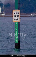
In the UK and Europe, most navigatable rivers linked to the sea list speed as Knots as shown on the attached photo (River Hamble UK)
 

Attachments

  • Sign.jpg
    Sign.jpg
    30.9 KB · Views: 250
Many thanks to all of those that replied. You answered my question and I learned a thing or two.

You are a bunch of gentlemen and scholars with the occasional pirate, scallywag and scoundrel thrown in for good fun.

Happy Holidays
 

1 knot is equal to 1 nautical mile which is 1 min of latuitude per hour --60 nautical miles is equal to 1 degree of latuitude -- there are 360 degrees of latuitude world wide (full circle) left / right wize (east /west)--- and 180 degrees up /down (north / south)--90 to 0 north and 0 to 90 south (in the old days with time and knots pulled out in a min of time being used to measure distance thus the 60 min of sailing time at 1 knot = 1 min of travel on a sea chart taking that and knowing which direction you were traveling ( by your compass) -- you could peg your location on a flat map or globe. by knowing you sailed say --20 hours at 3 knots due northeast (thus 60 nautical miles) -- you would be 1 degree north and 1 degree east of your last location on the map.
 

I think a MPH speed limit is only used in policed and/or protected waterways where authorities use radar guns to determine your speed. These guns can not show knots.
 

Top Member Reactions

Users who are viewing this thread

Back
Top