S.J.M. Rock with Map

boomer

Sr. Member
Jul 8, 2003
487
523
kentucky
Detector(s) used
army all terrain
this rock on lower devils creek and another on war fork east of McKee Kentucky are terrain code maps, not initials. what bothers me is that some of the carvings seem more like spanish land codes more than english or french. just a feeling.
see maps below, click to enlarge.
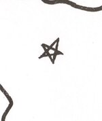
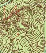
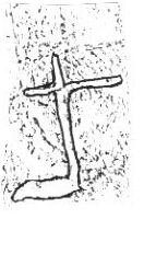
its a terrain code map. 1 points to dot which is a cave or rockhouse and it also points to where the cave or rockhouse is, in this case the miiddle of the S is a cliff with an S shape, number 3. 2 is an arrow that gives direction to go, once its found. lower part of the arrow points to a second rockhouse or cave, also points to left side of M. 4 shows that their are two caves or rockhouses near each other. 5 shows a flat ledge or path in front of both. 6 shows a ridge with two knobs high up with a sharp gap between. notice the left knob is lower than the right and the left has a sharper angle then the right, vary steep. 7 shows north direction and way to go. the 6 dots and SJM or saying 36 miles north to the location. i put the swift map star on here because it matches the SJM carving. at the S shaped cliff there is a small rockhouse, inside is an arrow carved from a flat rock that is sandstone and chipped to form the arrow and points west. on the west side of the gap at the knobs is a carving of a cross, could be a mine or showing a creek with a sharp left hand turn or a small valley. topo shows the two knobs and a rock vary high up with a gap between it and a large mountain. turkey track on rock points to knob gap.
 

Attachments

  • SJM carving 2.bmp
    625.1 KB · Views: 555
  • swift map star.jpg
    swift map star.jpg
    10.5 KB · Views: 505
  • 2 knobs swift map 6.jpg
    2 knobs swift map 6.jpg
    17.2 KB · Views: 1,304
  • rock high up.jpg
    rock high up.jpg
    8.2 KB · Views: 1,319
this rock on lower devils creek and another on war fork east of McKee Kentucky are terrain code maps, not initials. what bothers me is that some of the carvings seem more like spanish land codes more than english or french. just a feeling.
see maps below, click to enlarge.
its a terrain code map. 1 points to dot which is a cave or rockhouse and it also points to where the cave or rockhouse is, in this case the miiddle of the S is a cliff with an S shape, number 3. 2 is an arrow that gives direction to go, once its found. lower part of the arrow points to a second rockhouse or cave, also points to left side of M. 4 shows that their are two caves or rockhouses near each other. 5 shows a flat ledge or path in front of both. 6 shows a ridge with two knobs high up with a sharp gap between. notice the left knob is lower than the right and the left has a sharper angle then the right, vary steep. 7 shows north direction and way to go. the 6 dots and SJM or saying 36 miles north to the location. i put the swift map star on here because it matches the SJM carving. at the S shaped cliff there is a small rockhouse, inside is an arrow carved from a flat rock that is sandstone and chipped to form the arrow and points west. on the west side of the gap at the knobs is a carving of a cross, could be a mine or showing a creek with a sharp left hand turn or a small valley. topo shows the two knobs and a rock vary high up with a gap between it and a large mountain. turkey track on rock points to knob gap.

MAYBE, it is a "WBS"... dunno. (Up-Side Down). ??? :coffee2:
 

Last edited:
none

This is the 101 I was talking about. I have found this carving and it was suppose to have a keg of coins buried below it. It is actually swift, Jefferson, and munday and there was nothing there. I will say there is much more to it and where it leads will absolutely blow your mind. This quest has been never ending for me. I find something new every time I go and I will say my greatest find was an over sized carving of an Indian head not far from this carving. The only problem is the Indian head is pointing in the wrong direction. Also you are correct in you cipher
 

Last edited:
well I guess I am back, a little slow, but getting better. had a stroke back in june. sometimes a little slow in typing. the lower devil creek carving points to dock hollow on beaver creek east of frenchburg ky. at the end of the hollow are the two rock houses that had a furnace and mining tools in them. just below the rock houses, if you look just a little left you will see two lime stone pillars about 15 and 25 ft. high. the two knobs I saw are 1/4 mile up on dock hollow on your right we always called it the sinks at the end of the sink are the two high knobs. between the knobs is a slanted rock with a turkey track pointing down into the sink. on the back side of the knobs at the top of the cliff you will see the large rock,looks ready to fall. this rock is up next to the cliff, but you can walk in a small gap between the cliff and the rock. just to your right is the two knobs. is it swifts no idea. but there is an SJM cut on the small cliff at the front of the sink. the only reason I saw it was it was raining a little and the cuts stood out.
hammer859- the 101 is on cainey creek off little sandy river about 300 yards from the indian mine. the indian grave is just across from it.
 

Hi Boomer...back in the 80s Verne showed all that to me...we walked around all day in the sinks and he showed me the carvings and the cave...and one of the best limestone springs that I ever saw in dock hollow...I was all over that area for a good 5 or 6 years back when I was younger and could still climb the hills...Berry allowed me to look on his place also but someone came in and dug a deep hole up at the rocks that are at the base of the hill and wasn't very happy about it, and I don't blame him...I know what was originally carved on those rocks...problem is someone came in and cut a lot on nonsense into them that was not originally there...there's also the big pit just below that and the old mines across the creek...but from what I can find out most of them were done back when the iron furnace was in blast...they were getting dolomite to line the furnace with from them...now...one important thing...up Wynn Branch on the left as you start up in the limestone is a small cave...stay out of it if you go in there because it's full of dead air, or black damp as Verne called it, or possibly gas...we crawled back into it about 40 foot and we all decided the air smelled a little funny for a cave...by the time we got back out all of us had a bad headache and we just lay there on the side of the hill for about 30 mins. until our heads stopped hurting...I had a contract with the family that owned up Wynn back then and tried to get another one last year, but the land is now owned by the kids and they don't want anyone on it looking for the mines or treasure anymore...I think they may be hunting themselves and I told them I would send everything I found out, carvings, etc. when I was in there in the 80s...I don't know who owns Verne's old place...dock hollow is interesting but I never found any hard rock gold and silver there...neither did Verne as far as I know and he told me pretty much everything he knew...there were some people out of West Virginia that went up dock hollow and tore up a rock house with a backhoe, but they didn't find anything either...except an old hammer head they said had silver in it...I looked at it and it looked more like aluminum...or some kind of pot metal...
 

thanks 1320, the sinks are a really cool and odd place...Verne told me there was about 40 acres to the whole thing, but unless Swift used the sinks to bury his treasure in, there's nothing there...and also the Spratt Mound Works are really cool to go see...I've been there about three times...a lot of people think that Swift used a small furnace to smelt the ore in...but what I found was something much more...he had a full size furnace operation going...go on Yahoo and search colonial short stack blast furnace...that is what he had in operation and you can tell by what he says about it in the journal...they always came to the furnace in the spring and left out in the fall...the kind of furnace he was using was put into blast in the spring and stayed that way until sometime in the fall...around 120 days or so...that also explains why they left a crew to work the mines all winter...it was the best time to be underground...the workers could stay at a nice 50 degrees or so during the days and then go to their shelter in the evenings, and anyone who goes caving knows that in the winter if you go into a cave you have to start shedding clothes...the ore was piled up for when the furnace would be put into blast...the site where his furnace stood even has the trench left where he had a water wheel or ran the slag off into the creek...and the creek could easily have been damned, and if you notice in the journal when anyone was going in a southerly direction they had to climb the hill over the furnace...they just couldn't head south...I've also found rocks in the creek that I mistook from an old chimney but I'm convinced that they are the quarried stones he used to build his furnace...up on the side of the hill I found where he quarried the sandstone for the furnace...remember when Swift left he tore down all of his workings,..including his furnace...now he probably would have had a smaller furnace for making the silver pigs more pure and for making coin blanks...when they say that Jefferson was an expert at making molds...that didn't mean he made individual molds for each coin...but that he made steel stamp molds where the round blanks could be pressed with the image...that would explain why Swift's crowns were hard to tell from and original coins minted in England...Swift didn't care that everything they had built was torn down because he planned to come back and do everything on a large scale...
 

Last edited:
thanks 1320, the sinks are a really cool and odd place...Verne told me there was about 40 acres to the whole thing, but unless Swift used the sinks to bury his treasure in, there's nothing there...and also the Spratt Mound Works are really cool to go see...I've been there about three times...a lot of people think that Swift used a small furnace to smelt the ore in...but what I found was something much more...he had a full size furnace operation going...go on Yahoo and search colonial short stack blast furnace...that is what he had in operation and you can tell by what he says about it in the journal...they always came to the furnace in the spring and left out in the fall...the kind of furnace he was using was put into blast in the spring and stayed that way until sometime in the fall...around 120 days or so...that also explains why they left a crew to work the mines all winter...it was the best time to be underground...the workers could stay at a nice 50 degrees or so during the days and then go to their shelter in the evenings, and anyone who goes caving knows that in the winter if you go into a cave you have to start shedding clothes...the ore was piled up for when the furnace would be put into blast...the site where his furnace stood even has the trench left where he had a water wheel or ran the slag off into the creek...and the creek could easily have been damned, and if you notice in the journal when anyone was going in a southerly direction they had to climb the hill over the furnace...they just couldn't head south...I've also found rocks in the creek that I mistook from an old chimney but I'm convinced that they are the quarried stones he used to build his furnace...up on the side of the hill I found where he quarried the sandstone for the furnace...remember when Swift left he tore down all of his workings,..including his furnace...now he probably would have had a smaller furnace for making the silver pigs more pure and for making coin blanks...when they say that Jefferson was an expert at making molds...that didn't mean he made individual molds for each coin...but that he made steel stamp molds where the round blanks could be pressed with the image...that would explain why Swift's crowns were hard to tell from and original coins minted in England...Swift didn't care that everything they had built was torn down because he planned to come back and do everything on a large scale...

Interesting stuff, thanks for sharing. Did Verne show you the cave that had the large shaft going up thru the top? Close to it was a ledge that was rocked up. I saw these in 1983. Never heard what became of it. I don't remember where they were located either but it was close to Verne's home. He showed me a large boulder with a turkey track carving on the way to it.
 

yeah...Verne showed me the cave and we went into it...I'm a caver of old and the shaft looked natural to me...the really cool thing about the cave is the entrance...it is a vulva opening...these are common in Europe and were used as ceremonial caves...you can tell this by comparing the way the opening to the cave has been carved out to the ones in Europe...the whole area of the sinks, in my opinion, for what that's worth, was probably a larger care system that collapsed to form the sinks...there are probably tunnels there that still have not been explored...the Native Americans that were living there were cultivating the bottoms...Verne showed me a beautiful flint hoe that he plowed up in the bottom across from his home...and then there is the indian flint mine up Clifton Cr. on the left not far from the dolomite mines...and also the snake mound works...this area at one time was a major indian encampment...interesting stuff...
 

Did a fellow, I think his last name was Back, find a silver mine in Menifee back in the 1980's??? If memory serves me correctly, he had pictures of carved signs, landmarks mentioned by Swift, and a mine on his property. I am pretty certain it was mentioned in a newspaper.

I never heard any more about it... Anyone have any info???

Thanks,
Brent
 

not that I heard, and back in the 80s I wouldn't have missed that information...but I might have...if anyone runs over that old news story I'd love to read it...
 

I am visiting friends in that area today. I will probably not do any investigating, except to ask my friends of the locations of carvings and local lore. I will keep everyone updated.
 

I didn't get any good info from my friends during my last visit. They have a son that has hunted all over Menifee County for ginseng, morels, grouse, etc. that I will contact soon. He lives in a nearby town. I will call or visit him this weekend.
 

I am glad to see some activity related to Swift on this forum again, you guys have posted some new and interesting details. Thanks for sharing!
 

I talked with another friend and he stated that his Dad has bought some property in Menifee Co.and it was stated by the former owners that it has a silver mine on it. They didn't know the location.

My friend says that the property has lots of caves and rock houses on it. He said he got the "Heebie Jeebies when he visited there. LOL!!!

Sounds like Vernon Spratts place up in Clifton, it sold recently.....
 

Do you know who bought it??? Is the new owner from Bath County???
Do you mind to friend me? I would like to chat with you.
 

Top Member Reactions

Users who are viewing this thread

Back
Top