Rock You Like A Hurricane

Kauziamos

Jr. Member
May 28, 2014
65
99
Primary Interest:
All Treasure Hunting
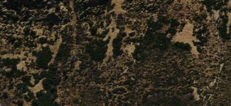
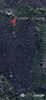
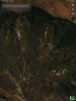
Howdy everyone. Gather around the campfire, I’ve got a story to tell. Actually, I’m just here to divulge my find, which would be the “lost” Spanish gold mine in the Hurricane Cliffs Of Utah. And by mine, I mean the entire mountainside of workings. Animals, a giant bell, and even bigger heart (massive vault?), triangles, the whole shebang. About the heart: almost two football fields long, it’s black with a giant white eyecatcher at its base. It’s flanked on its sides by, well, you tell me. I see an Indian aiming it’s bow at the heart on the left, and on the right I see giant conquistador standing atop an upside down guitar (figure eight) with a skull head looking away, all the while holding up a sword, saying, go ahead, make my day. What do you see?
It’s the search for the truth that drives me, not greed. Here y’all go. Good luck out there amigos. Feel free to share your finds from in and around the area. I know some of y’all have them!
F3C6F207-73B5-47B5-AD91-E82F6A4BD662.jpg
1688DD43-97B4-43C9-A26D-647C9833CECF.jpg
7BF4EE97-B477-4A88-B1BF-4CA26ED67971.jpg
 

Last edited:
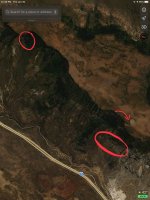
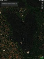
The silence is deafening. I’ll add some more for the armchair explorer. Look just north of Pintura, and east of Ash Creek Resevoir in the cliffs that run along I-15. I like Apple Maps better for this site, but google earth works too. I’ve circled the heart and the worked area. Above the worked cliffside is a large circular imprint on the bluff that I marked with an arrow to help you locate it easier.
AC56E4B1-7CE7-44F0-A6B4-835652578B1A.jpeg
B3B18643-CD80-4E17-88E8-035729395FB6.jpg
 

Last edited:
I guess it all depends on what you see its hard for me to make out. Sounds like your doing something you love and if someone is skepticle they wont see what you do.. But I hope you are on to something and keep doing what you love thats what its all about Good post Tommy
 

I guess it all depends on what you see its hard for me to make out. Sounds like your doing something you love and if someone is skepticle they wont see what you do.. But I hope you are on to something and keep doing what you love thats what its all about Good post Tommy

Thanks Tommy. The more you learn, the more you see things with fresh eyes. Consider this: Ever tried reading Chinese or any very non English language? Chances are you understand 0%. But the more you learn, the more you see and understand. I feel like I understand about 1% as I’ve been going at this alone for about 5 years now, and passively at that. I guess that’s more than most humans, so that’s something. Or nothing. Hell, I don’t know.
 

well . . . I kinda see tracks
but bigfoot in Utah ?

Well, I should hope at the very least that you would see the numerous tracks/trails crisscrossing the mountainside in the second pic down, first post. Here’s the thing Bill- we as humans erect towers into the sky, create entire artificial islands, great pyramids; do you attribute those to Bigfoot as well? Is it really a stretch of the imagination to think that the Spanish (or whoever) that mined and moved metric **** tons of rocks couldn’t have moved some around to create markings, some that could only be seen from feet away, others from miles away. Ever heard of a LANDMARK??? Well, you’re looking right at some right now. Whether you choose to take that as fact is up to you.
 

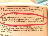
I just found this in Thomas Terry’s Treasure Map Atlas. Not an exact fit, but...
DCE73B50-7253-4A9C-ABC5-6A140CCBFFD2.jpeg
 

Attachments

  • CDED51B9-9A48-494A-BAE0-E9608747B05C.jpeg
    CDED51B9-9A48-494A-BAE0-E9608747B05C.jpeg
    1.7 MB · Views: 181
Last edited:
Wish I could add more right now! And yes, ALT is the site I was referencing on your post. Waiting on the book I ordered...was hoping more people would chime in. Seems this was a pretty important area stretching from St. George to Cedar City. Brigham Young thought so. The Shotput Man says so....
 

Probably you have already seen this discussion, (on another channel, hopefully this is not breaking the rules)
Ancient Lost Treasures ? View topic - Hurricane Cliffs mine site

It seems to be much the same story at first read-over.

Please do continue;
:coffee2: :coffee: :coffee2: :coffee2:
So I am the one who started the post in Ancient Lost Treasures. Me and my father found the marker stone and the stone carvings. I've been away from it for quite a while but am now growing interested in picking up where we left off. My dad passed away going on 4 years ago. I have attached the article I sent to the Old Spanish Trail Association back in 2007 to verify that I am the one who started this post. Have some other thoughts about the location after rereading a few articles on the lost mine.


1643380408859.png
1643380408859.png


Trail History
The 1811 Marker and a tale of Gold
by Paul Ostapuk (Forwarded by Leon Matheson)
I found out that the 1811 inscription was found
near the Hurricane Cliffs in southern Utah.
There's a rumor of a story of Spanish gold. As
you can see the inscription was part of a
scalloped marker.
From the finder:
"There are also
several stories
about a lost
Spanish Gold
mine in the
Hurricane cliffs.
We have also
found several
other interesting
things, one of
which is a writing
at the base of a
cliff with
numerous
writings as well
as a box with the number 426 in the middle of
it another is the crest of a peak with a hole
chipped out in the stone that can be seen at a
certain time of the day from close to these
writings, the distance between the two is about
4 miles. We also found an old fire pit at the top
of the mesa which sits just above where the
marker stone was found. There is also dark
brown pottery (almost black) that is on top of
the mesa.
I have also talked with an old man that lived in
the area for his whole life and he told us of
finding a cache of gold bricks in the area of the
marker stone, he has since died but he told us
that there was an old willow and a spring
where he located them. When I talked to him
he was bed ridden and on his death bed. His
explanation as to why he did not have the gold
bricks was that when he found them he was
riding his horse bareback and was 12 years old
at the time the bricks were too heavy to pack
riding bareback. When he got home his
parents did not believe him and would not help
him find them. He never could find them again.
It is my belief that Don Jose Rafael Sarricino
came here to find the buried gold bricks that
had been left by Spanish explorers before him
who had tried leave in the summer with a load
that was to heavy to haul when the
temperatures were in the hundreds and water
was worth more than gold, there is no water
suitable for drinking for many miles from this
location. I believe they buried the gold in
anticipation of a return, when that was not
possible they made a deal with Sarracino
giving him the information in return for a
portion of the cache.
Jim Knipmeyer knows of an 1811 inscription
that is located northeast of Holbrook, Arizona,
not in Utah. It is the date "1811" along with the
name "Silbestre Esquibel," the name(s) printed
in capital letters. The inscription is incised into
a rock face.
Background on José Rafael Sarracino
Like the first Pino families, merchants from
Mexico City, the Sarracinos were merchants
from Chihuahua. The first into New Mexico
was José Rafael Sarracino in the late 1700s.
He married Maria Gutierrez in 1787. Like many
of the caravan merchants during this time, his
wife and children resided in Chihuahua while
José was "on the trail." Being a merchant on
the El Camino Real was a political appointment
and a coveted job for the profits that could be
made. For this reason, the male children of
these merchants were brought into the "family
business."
The two sons of José Sarracino likewise
became El Camino Real merchants, residing in
Santa Fe with their families around 1820.
However, with the arrival of the Santa Fe Trail,
and later the railroad, higher-quality goods at
lower prices were brought into New Mexico
(and without the political corruption from
Mexico). The El Camino Real began to die
and, along with it, the merchants and their
prosperity.
The two Sarracino merchants were suddenly
out of a job, becoming ranchers east of Santa
Fe and in Truchas. They quickly proved to be
good ranchers. Shortly after the Civil War,
several families of Sarracinos ventured into the
Rio Abajo and southern New Mexico, running
ranches from La Joya to the Diamond A near
Deming, and of course, near Socorro. In the
1880s, the Sarracino Ranch ran from the Rio
Salado to about U.S. 60, near Water Canyon.
Some of the Sarracinos in today's Socorro are
descendents of these successful sheep and
cattle families.
In the early 1800s, Spanish restrictions against
trade were apparently slackened, reflecting an
official change in policy where trade with Indian
groups on New Mexico's northern frontier was
seen as a necessity in order to create a buffer
against American encroachment. Part of this
was an attempt by the Spanish to make the
Indians dependent upon them through trade.
As part of this new diplomacy, the Spanish
began encouraging trade expeditions (Weber
1971:28). As trade with the Utes developed,
two major travel routes from New Mexico into
Utah became established: the main Spanish
Trail and the northern branch of the Spanish
Trail. The rapidity of the development of the
route is demonstrated by the journey of Manuel
Mestas, a 70-year-old genizaro that had
served the Spanish as an interpreter to the
Utes for 50 years, when he traveled to the
Utah Lake area in 1805 and recovered stolen
horses from the Timpanogos Utes, presumably
following the route of the main Spanish Trail
(Hafen and Hafen 1954:85; Creer 1947). When
Jose Rafael Sarracino spent three months in
Ute territory in central Utah in 1811, he found
the Indians already in possession of Spanishmade
knives, razors, and awls (Weber
1971:25). By 1813, Utes as far away as the
Sevier River in central Utah were accustomed
to trading with the Spanish (Hafen and Hafen
1954:267; Smith 1974).
The Utes were eager to trade with the Spanish
and were particularly interested in procuring
horses, though they also obtained other items
such as blankets, knives, beads, and
agricultural products. The Spanish were
equally eager to trade in order to bolster their
meager economy. Slaves were most highly
desired, but tanned hides, furs, and dried meat
were also received from the Utes (Hafen and
Hafen 1954:261). As the slave trade became
established, Utes began raiding unmounted
Western Shoshone, Southern Paiutes, and
Gosiutes as far west as southern Nevada to
steal women and children to sell to the Spanish
in New Mexico for use as domestic servants
and shepherds (Callaway et al. 1986:354). In
1812, a Spanish law was passed prohibiting
Indian slavery. This did little to curb the trade,
and pelts and slaves continued to be the major
items of exchange with the Utes (Hafen and
Hafen 1954:263-264). Local lore suggests that
the Spanish mined on Ute Mountain and that
Spanish artifacts have been found on occasion
in the McElmo Canyon area, though
confirmation is lacking (Kenyon and Kenyon
2004; Jeter 2004).

Mod: Your link was a downloadable pdf file which sometimes can download viruses. Can you copy and paste from the pdf with out posting a downloadble file? Thank you!
 

Last edited:
So I am the one who started the post in Ancient Lost Treasures. Me and my father found the marker stone and the stone carvings. I've been away from it for quite a while but am now growing interested in picking up where we left off. My dad passed away going on 4 years ago. I have attached the article I sent to the Old Spanish Trail Association back in 2007 to verify that I am the one who started this post. Have some other thoughts about the location after rereading a few articles on the lost mine.

Mod: Your link was a downloadable pdf file which sometimes can download viruses. Can you copy and paste from the pdf with out posting a downloadble file? Thank you!
No mod has posted in this thread.
 

Trying to figure out what you found?
 

Trying to figure out what you found?
Trail History
The 1811 Marker and a tale of Gold
by Paul Ostapuk (Forwarded by Leon Matheson)
I found out that the 1811 inscription was found
near the Hurricane Cliffs in southern Utah.
There's a rumor of a story of Spanish gold. As
you can see the inscription was part of a
scalloped marker.
From the finder:
"There are also
several stories
about a lost
Spanish Gold
mine in the
Hurricane cliffs.
We have also
found several
other interesting
things, one of
which is a writing
at the base of a
cliff with
numerous
writings as well
as a box with the number 426 in the middle of
it another is the crest of a peak with a hole
chipped out in the stone that can be seen at a
certain time of the day from close to these
writings, the distance between the two is about
4 miles. We also found an old fire pit at the top
of the mesa which sits just above where the
marker stone was found. There is also dark
brown pottery (almost black) that is on top of
the mesa.
I have also talked with an old man that lived in
the area for his whole life and he told us of
finding a cache of gold bricks in the area of the
marker stone, he has since died but he told us
that there was an old willow and a spring
where he located them. When I talked to him
he was bed ridden and on his death bed. His
explanation as to why he did not have the gold
bricks was that when he found them he was
riding his horse bareback and was 12 years old
at the time the bricks were too heavy to pack
riding bareback. When he got home his
parents did not believe him and would not help
him find them. He never could find them again.
It is my belief that Don Jose Rafael Sarricino
came here to find the buried gold bricks that
had been left by Spanish explorers before him
who had tried leave in the summer with a load
that was to heavy to haul when the
temperatures were in the hundreds and water
was worth more than gold, there is no water
suitable for drinking for many miles from this
location. I believe they buried the gold in
anticipation of a return, when that was not
possible they made a deal with Sarracino
giving him the information in return for a
portion of the cache.
Jim Knipmeyer knows of an 1811 inscription
that is located northeast of Holbrook, Arizona,
not in Utah. It is the date "1811" along with the
name "Silbestre Esquibel," the name(s) printed
in capital letters. The inscription is incised into
a rock face.
Background on José Rafael Sarracino
Like the first Pino families, merchants from
Mexico City, the Sarracinos were merchants
from Chihuahua. The first into New Mexico
was José Rafael Sarracino in the late 1700s.
He married Maria Gutierrez in 1787. Like many
of the caravan merchants during this time, his
wife and children resided in Chihuahua while
José was "on the trail." Being a merchant on
the El Camino Real was a political appointment
and a coveted job for the profits that could be
made. For this reason, the male children of
these merchants were brought into the "family
business."
The two sons of José Sarracino likewise
became El Camino Real merchants, residing in
Santa Fe with their families around 1820.
However, with the arrival of the Santa Fe Trail,
and later the railroad, higher-quality goods at
lower prices were brought into New Mexico
(and without the political corruption from
Mexico). The El Camino Real began to die
and, along with it, the merchants and their
prosperity.
The two Sarracino merchants were suddenly
out of a job, becoming ranchers east of Santa
Fe and in Truchas. They quickly proved to be
good ranchers. Shortly after the Civil War,
several families of Sarracinos ventured into the
Rio Abajo and southern New Mexico, running
ranches from La Joya to the Diamond A near
Deming, and of course, near Socorro. In the
1880s, the Sarracino Ranch ran from the Rio
Salado to about U.S. 60, near Water Canyon.
Some of the Sarracinos in today's Socorro are
descendents of these successful sheep and
cattle families.
In the early 1800s, Spanish restrictions against
trade were apparently slackened, reflecting an
official change in policy where trade with Indian
groups on New Mexico's northern frontier was
seen as a necessity in order to create a buffer
against American encroachment. Part of this
was an attempt by the Spanish to make the
Indians dependent upon them through trade.
As part of this new diplomacy, the Spanish
began encouraging trade expeditions (Weber
1971:28). As trade with the Utes developed,
two major travel routes from New Mexico into
Utah became established: the main Spanish
Trail and the northern branch of the Spanish
Trail. The rapidity of the development of the
route is demonstrated by the journey of Manuel
Mestas, a 70-year-old genizaro that had
served the Spanish as an interpreter to the
Utes for 50 years, when he traveled to the
Utah Lake area in 1805 and recovered stolen
horses from the Timpanogos Utes, presumably
following the route of the main Spanish Trail
(Hafen and Hafen 1954:85; Creer 1947). When
Jose Rafael Sarracino spent three months in
Ute territory in central Utah in 1811, he found
the Indians already in possession of Spanishmade
knives, razors, and awls (Weber
1971:25). By 1813, Utes as far away as the
Sevier River in central Utah were accustomed
to trading with the Spanish (Hafen and Hafen
1954:267; Smith 1974).
The Utes were eager to trade with the Spanish
and were particularly interested in procuring
horses, though they also obtained other items
such as blankets, knives, beads, and
agricultural products. The Spanish were
equally eager to trade in order to bolster their
meager economy. Slaves were most highly
desired, but tanned hides, furs, and dried meat
were also received from the Utes (Hafen and
Hafen 1954:261). As the slave trade became
established, Utes began raiding unmounted
Western Shoshone, Southern Paiutes, and
Gosiutes as far west as southern Nevada to
steal women and children to sell to the Spanish
in New Mexico for use as domestic servants
and shepherds (Callaway et al. 1986:354). In
1812, a Spanish law was passed prohibiting
Indian slavery. This did little to curb the trade,
and pelts and slaves continued to be the major
items of exchange with the Utes (Hafen and
Hafen 1954:263-264). Local lore suggests that
the Spanish mined on Ute Mountain and that
Spanish artifacts have been found on occasion
in the McElmo Canyon area, though
confirmation is lacking (Kenyon and Kenyon
2004; Jeter 2004).
 

Top Member Reactions

Users who are viewing this thread

Back
Top