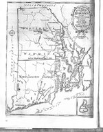
Rhode Island map 1636-1659

johnnyblaze

Silver Member
Dec 20, 2010
3,208
1,751
Rhode Island
🥇 Banner finds
2
Detector(s) used
T2 SPECIAL EDITION
Primary Interest:
Other

Attachments

  • RhodeIsmap1659a.jpg
    RhodeIsmap1659a.jpg
    344.7 KB · Views: 6,239
i love old maps i am setting up a presentation for a club meeting showing everyone how to use maps to find places to hunt. there isn't anthing from the 1600s around here but the oldest places around here are from the 1830s but only a small handful are even standing and one of the buildings built in 1837-38 is considered to be the best example of old log architecture in north america, but it now has severe rot and had been sadly renovated in 1988 to be more modern :'(.
 

treasurepirate1 said:
i love old maps i am setting up a presentation for a club meeting showing everyone how to use maps to find places to hunt. there isn't anthing from the 1600s around here but the oldest places around here are from the 1830s but only a small handful are even standing and one of the buildings built in 1837-38 is considered to be the best example of old log architecture in north america, but it now has severe rot and had been sadly renovated in 1988 to be more modern :'(.

Hey TP i live approximately where the "V" is in providence :thumbsup:

The cool thing about this particular map is its really no good for finding detecting sites
but possible Native American sites. I know are along these rivers they lived..Some of these rivers still exist in the deep woods around here :read2:


Blaze
 

Top Member Reactions

Users who are viewing this thread

Back
Top