research works

BenVa68

Hero Member
Joined
Mar 9, 2018
Messages
504
Reaction score
1,731
Golden Thread
0
Location
Hopewell va.
Detector(s) used
Technetics T2+ Equinox 800
Primary Interest:
Metal Detecting
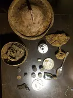
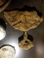
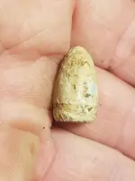
I did some research on historic aerials and discovered the location of an early 1900s homesite not far from where i live. I went to check it out after work yesterday and right away i could tell where it was. It is currently woods and part of a school yard and i don't believe it has ever been hunted. Virgin site! Usually the first time i go to a new site the first time it is just to get a feel for what's there, where it was located, how much trash, etc. I found several items from the home and i have a pretty good idea how the house was orientated. No coins or silver yet but i am fairly confident i should find some. I decided to head towards the creek which was very nearby and i dug a .44 cal bullet which has been identified as Civil War era. During my research i also discovered there were 2 roads going thru this location leading from City Point to Petersburg so i am hoping there was a camp there. It would be an ideal location for one. off the road, on a hillside and beside a creek mid way to Peterburg. It is so exciting when you do the research and it pays off!
 

Attachments

  • 20180627_204317_resized.webp
    20180627_204317_resized.webp
    426.3 KB · Views: 108
  • 20180627_204153_resized.webp
    20180627_204153_resized.webp
    417.3 KB · Views: 67
  • 20180627_203906_resized.webp
    20180627_203906_resized.webp
    87.1 KB · Views: 62
Upvote 14
I'm a believer also. I use two different libraries also. Congrats on the finds:occasion14:
 

Is it only a matter of time before we add drones to our list of essential tools?

Nice job on that site.
 

Nice research and hunt! :occasion14:

Good Luck on finding silver! :icon_thumleft:
 

Sanborn Fire Insurance Maps really help as well...just depends if you can locate a Sanborn map for the area of interest...that and the Maprika app.
 

Sanborn Fire Insurance Maps really help as well...just depends if you can locate a Sanborn map for the area of interest...that and the Maprika app.

I found another app called "old maps" and it shows your current GPS location on old maps. Is that what maprika does also?
 

I just realized one of the shotgun shells I dug from here was a UNC New Club. That means 1867 to 1911. This site is definitely looking more promising by the minute.
 

Nice research and nice finds. Congrats
 

Yep...shows you moving around on the map made by Maprika. Pretty much just a Sanborn map with current GPS info on it. Shows you where the houses were at one time...or maybe they could still be standing...never know until you get out in the field or use some Google foo and see what you can see from a satellite view.


I found another app called "old maps" and it shows your current GPS location on old maps. Is that what maprika does also?
 

Top Member Reactions

Users who are viewing this thread

Back
Top Bottom