Remarkable Rocks

Howerton Bradwell

Jr. Member
Nov 28, 2013
35
65
Maysville, Kentucky
Detector(s) used
Red Baron by Bounty Hunter
Primary Interest:
All Treasure Hunting
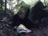
I located these back in 1987. The land they are on is now off limits because the family divided the land up between the kids, and one of them doesn't want to possibly become rich, and to quote them when I tried to get another contract to look again, "We don't want nobody looking on that land." It's their loss. It also helps that Swift's initials along with the date 1767, his name carved on a rock with the letter turned upside down and backwards, horse shoe carvings, turkey foot carvings, snake carvings, slag in the creek, the blue spring, the monument rocks, a Maltese Cross carving, the location where his short stack colonial furnace sat, the quarry where he obtained the sandstone rock for the furnace, the quarry where he obtained the limestone to mix with the ore when the furnace was in blast, the place where he damned the creek for the water wheel, and above the Remarkable Rocks the creek forks three ways at the same point are all within two square miles of this location. It's somewhere in Eastern Kentucky. This area is also where I took the hard rock sample that contain gold and silver verified from the assay. I wish I had known 30 years ago what the ore looked like. Remarkable Rocks.jpg
 

Last edited:
The one leaning against the other is a big clue....but I think he says water is involved....still its worth checking out...one of these days....and where you find some gold and silver you might find more and even better at the same level further up or down the hill/valley.
 

I located these back in 1987. The land they are on is now off limits because the family divided the land up between the kids, and one of them doesn't want to possibly become rich, and to quote them when I tried to get another contract to look again, "We don't want nobody looking on that land." It's their loss. It also helps that Swift's initials along with the date 1767, his name carved on a rock with the letter turned upside down and backwards, horse shoe carvings, turkey foot carvings, snake carvings, slag in the creek, the blue spring, the monument rocks, a Maltese Cross carving, the location where his short stack colonial furnace sat, the quarry where he obtained the sandstone rock for the furnace, the quarry where he obtained the limestone to mix with the ore when the furnace was in blast, the place where he damned the creek for the water wheel, and above the Remarkable Rocks the creek forks three ways at the same point are all within two square miles of this location. It's somewhere in Eastern Kentucky. This area is also where I took the hard rock sample that contain gold and silver verified from the assay. I wish I had known 30 years ago what the ore looked like. View attachment 1186926
Yeah, MOST land-owners are like that...
 

These rocks sit down in the creek...prettiest little creek you'd ever want to see runs under them...about 12 to 14 ft. wide.
 

I only moved to Maysville about 13 years ago. I lived in this part of the country where this photo was taken for almost 40 years and know this area like the back of my hand. Certain things have to come together for the land to fit the description in his journal. About one tenth of a mile above these rocks the creek forks from the same place in three directions. Above the middle fork is a large standing rock and on the side of the cliff is carved a Maltese Cross. Within a mile of these rocks he has his name carved in a rock shelter and I posted a photo of that one also. About a mile and a half in an opposite direction his initials and the date 1767 are carved in another rock shelter. These locations all fall along 37 degrees 56 or 57 min. and west of 83 degrees. I've found carved on top of a rock...different from the photo posted on one of the Swift threads...the following..."High on a Mountain, carved on a rock, are three little words, forget me not." There is slag in the creek below a certain point where the colonial short stack furnace stood, and about a quarter of a mile east and below this location stand two large rocks, one about 15 foot high and the other about 25 foot high at the mouth of the hollow. You have to pass between them to get to the place. There is a location close to where the furnace sat where there is an old sandstone quarry, and also a limestone quarry. On a rock across from the hollow is a flat rock with a snake carved on it that is very like the snake flag or emblem used by the early colonials before the revolutionary war. The snake points up the hollow but it is cut up into different sections...the unite or perish flag. Everyone seems to think that all these the clues that Swift left to his mines and treasure are spread out over hundreds of miles, but his description of the land where all this took place is all contained within 5 square miles. I have also located a large flat rock the size of a table 5 foot long and about 2 and one half foot wide on top of a cliff where you can stand and there is a small hole in the cliff on the other side to the west. It's not a natural arch, but a hole, possible the beginning of an arch, just big enough to step through. I had to have a look at it...LOL. This area is also where I located the gold and silver hard rock fissure vein. I'm going back to get a better sample from the parent rock that makes up the material that has been deposited in the fissure and have it assayed. I took the last assay material from the far edge of the deposit. I've got a contract with the landowners on this property, but the other property where the remarkable rocks sit are off limits to any treasure hunters. I'll post the results of the new assay.
 

Last edited:

Top Member Reactions

Users who are viewing this thread

Latest Discussions

Back
Top