Questions for all you creekwalkers?

redbeardrelics

Hero Member
Jan 3, 2014
891
1,024
Maryland's Eastern Shore
Detector(s) used
Garrett GTI 2500, (Ace 250 spare)
Primary Interest:
Other
I have spent a lot of time in the creeks swimming, wading, fishing and turning rocks looking for crawdads or hellgrammites, but have never found a point in the creeks. I feel like I really missed out never thinking to search the gravel bars for artifacts. I was wondering about why points are found in the creeks. Do you think (or know), that it is because the points were lost or rejected while knapping them creekside, or lost while hunting for game in or near the creeks, or do you think most of them are there because the creeks have shifted over time and eroded through the actual campsites, or probably all of the above? Just curious as to how or why the points ended up in the creeks?
 

Upvote 0
Other than tossing them in the creek I would say you are correct.
Personally I don't find many in the creeks unless there is a more concentrated spot that they are falling/washing out of an that is actually what I am truly hunting for. Find the source and find them unscathed from the potentially harsh creek conditions.
 

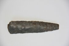
I found this in a creek bed in Montgomery Co. MD. But it's tough going for sure - my brain and eyes get tired having to visually process a million stones a minute. Have you done most of your hunting on the eastern shore? Just guessing, but maybe the lack of elevation change and sandy soils make the streams meander more, so less likely to find over there??? How wide is the typical flood plain?

Go find a Solutrean blade dude!
 

Attachments

  • 1st Point 005 web.JPG
    1st Point 005 web.JPG
    117.9 KB · Views: 100
I found this in a creek bed in Montgomery Co. MD. But it's tough going for sure - my brain and eyes get tired having to visually process a million stones a minute. Have you done most of your hunting on the eastern shore? Just guessing, but maybe the lack of elevation change and sandy soils make the streams meander more, so less likely to find over there??? How wide is the typical flood plain?

Go find a Solutrean blade dude!
Most of my time in the creeks was in Harford County, MD, and if there were many there I suspect I would have stumbled upon them by dumb luck, as I have found several others not in the creeks, with just dumb luck. Over here on the eastern shore I have looked in some really small creeks recently, and not found anything. Most of the larger creeks in my local hunting grounds have long ago been deepened and straightened, and turned into "ditches". They tell me these ditches are the oldest "tax ditches" in the US, dating back to the late 1700's. I suspect I haven't found any in the creeks I have trampled thru because of what 11KBP has noted, and that the creeks around here haven't shifted much in the last 10,000 years to have eroded through many sites?
PS. I am still looking for a Solutrean blade, or even a fluted point. I don't know that I have found any Paleo artifacts, unless some of the numerous scraper or utilized flakes might be that old.
 

I hunt many creeks and they do a lot if shifting here because the way the land lays . I believe most points are bank wash outs I always tend to find them right past hard turns in the creek . You could walk a hundred yards and see nothing then hit a bend and bam you will find debris so look around all those turns and see if that helps ... Remember patience is needed looking at all those rocks ;)
 

I live on the MD Eastern Shore and hunt (almost exclusively) the creeks and rivers and shorelines anywhere I can access w/ my kayak or by foot (not so much by foot). Around here, we're tidal, so the water comes and goes twice/day. One wave can reveal something you wouldn't have seen a moment before. And much of what's around here is eroded into the water. Tons and tons of hunting grounds, camp grounds used by generations over the millennia all feed the waters- and pop up w/ certain regularity in fields (if you have permission, which I don't, generally). W/ the growing popularity of this hobby and the focus of local school/college/university archeology interests has made the pickins a bit slimmer. And yet there's always more. Might have to look a little harder- good light is really helpful as it reflects off the knap divots- and around here you'll find a lot of quartz- which shows well even on a rock-n-shell crowded beach or riverbank. Also jasper and many shades of chert. Once your eye is 'trained' on what you want to see, it'll be easier. Just keep your eyes peeled and check any shore or gravel/sand bar you come across. All the things you mentioned contribute to the number of points and tools we find around here (and anywhere w/ water activity), but the real thing about here is the tidal action- which reveals new potential every day, twice a day. Happy hunting! Yak
 

I concur with the OP in that I spent a huge amount of time in and around creeks in my childhood, and thru the present, whether piddling around, searching for bait, fishing, etc, etc. without finding a thing.

The past 4 years I have been consistently 'working' a creek using the digging-and-sifting method to locate fossils.

In all that time, I have found one, single point.... found a pipe bowl and some pottery sherds over the past 4 years, but just a single point.

Perhaps it is like the old saying regarding real estate: location, location, location.... that and actually looking for artifacts while in/around the streams
 

I actually found a scraper the other day eroding out of the bank on the waters edge. I find most of the pottery in the creeks and not much on land. So I guess they come out of the banks.
 

We found a point in our stock yard 100 yards from the nearest water; I can only figure that it would have been a kill.
 

I've only been creek walking for almost a year and still honing my finding skills, thinking luck is huge part of it. I've found about 80 shards and the biggest part of them are different types/colors. Found them in sand bars mostly but have found some sitting on rocks on the bank after a big gully washing rain, alot of them were in bends close to the bank. Found a guilford point sitting on top of rocks on a straight section and found a point/knife stuck between rocks in a rock bar under water a few feet up from where the guilford was. Right before the straight section are several bends and some big logs and 2 stumps we can't remove from the creek. My theory is they are washing out of the banks since they don't have the dark creek patina on them. The banks are deep, anywhere between 6' to 10' but the creek is shallow most the time. As for your question, I think it's probably all of the above but maybe in my property it was a campsite and the creek has eroded that deep over time. I have yet to find anything in my land above the creek and we have plowed gardens in two different spots not far from it.
 

In my area they lived along small creeks and streams and the big river. If you disk the ground that is sometimes 100 ft above the creek bed you will find artifacts of all types. We have such heavy erosion here that what was a small creek that was a few feet deep back 5000 yrs ago is now a ravine that is 30 to 100 ft down from where it was. The landscape that far back was much more level and due to the drop in the water table, the creeks have wash down lower and the banks have slide in to them loading them with artifacts. The creeks here are loaded with points, in one small ravine that only has water when it rains I know for a fact that 1000s of points have come from that one alone. The way I try to get it across to folks is for them to think how many people live out in the country now and by water ways and we have only been here close to 300 yrs, well they were here 10,000 or more years, just think of all the camp sites and village sites and due to erosion it has put there signs of living in the waterways, ravines and ditches and their trash is our treasure now. In the county I live in you can not break dirt anywhere without finding some type of sign. We have to remember this land does not look like it did then, what at onetime was a rolling hill land is now steep hills and washes.
 

I live on the MD Eastern Shore and hunt (almost exclusively) the creeks and rivers and shorelines anywhere I can access w/ my kayak or by foot (not so much by foot). Around here, we're tidal, so the water comes and goes twice/day. One wave can reveal something you wouldn't have seen a moment before. And much of what's around here is eroded into the water. Tons and tons of hunting grounds, camp grounds used by generations over the millennia all feed the waters- and pop up w/ certain regularity in fields (if you have permission, which I don't, generally). W/ the growing popularity of this hobby and the focus of local school/college/university archeology interests has made the pickins a bit slimmer. And yet there's always more. Might have to look a little harder- good light is really helpful as it reflects off the knap divots- and around here you'll find a lot of quartz- which shows well even on a rock-n-shell crowded beach or riverbank. Also jasper and many shades of chert. Once your eye is 'trained' on what you want to see, it'll be easier. Just keep your eyes peeled and check any shore or gravel/sand bar you come across. All the things you mentioned contribute to the number of points and tools we find around here (and anywhere w/ water activity), but the real thing about here is the tidal action- which reveals new potential every day, twice a day. Happy hunting! Yak
Hey there Yakker, I am new here, and glad to see another eastern shore collector /researcher here. I agree with everything you posted here, and have been doing some tidal shore walking myself the last few years (Chester & Bohemia Rivers) , and found some points in each location that I have looked. It sure makes crabbing in the middle of the afternoon, or at low tide a lot more fun if I can take a break and go walk the shoreline a bit while the traps set awhile. lol I wasn't very clear in my original post, in that I understand about the shoreline erosion into habitation sites, within the tidal parts of the tributaries, just wondering what your thoughts and experiences are with looking upstream in the areas above the tidal zones. Do you finds artifacts in those areas too? I am starting to get the impression that around here, those small creeks have pretty much stayed in the same channel, or at least the same low lying swampy area since before peoples were here, so that for the most part, they have not eroded or meandered through many campsites? I am up in QA County, how about you? Thanks
 

Hey Red-
Not the same at all- not one bit- looking in non-tidal areas. And around these parts there are ditches gridding through all the low-lying areas making them marginally livable (tho they flood every sing time we have a modest storm). The true headwaters of the major rivers around there are pretty much the same, but keep in mind that those ditches keep the water out of low-lying areas. The land and water profiles would have been different for sure 500-10,000 years ago. With that in mind, I've pretty much actively chosen not to really look hard in those headwaters areas- unless I'm looking for a dump, but that's another story.. In fact, in the years I've been looking, I have only found 1 single point in a creek. I did, however, find shark's teeth- my reason for being at the location to begin with. See, when I first started looking for points and such, I really didn't have a clue. I looked any and everywhere- from drainage ditches with any sort of sandy-rocky wash, to forest paths- and under big trees where nothing would grow and there'd be sand, dirt and gravel. I've found 1 point in a path in the woods- and that one from the creek. I'd suspect the best is still under the ground in the many, many fields around here. Just have to get permission, that's all. I guess I'd rather kayak than walk a field, given the option... HH! Yak Kent Co.
Oh- and an afterthought. It occurs to me that when the original people lived and thrived here, this was a summer place- a place with everything for the hunter/fisher/gatherer for the season. They migrated back and forth with the seasons. That's nothing new. But consider that when folks inland camped and moved about from season to season, the headwaters might be the winter place- up higher w/ more sun exposure. There would be signs of artifacts and of community. Here, I think they were coming from the western shore, so the headwaters of these E.S. rivers don't have the significance as the inland rivers- they're not high and dry, but marshy, swampy, perennially wet areas. Of course, maybe they were dry way back then... I could be way off, but I just thought of it and thought I'd risk thinking out loud. Cheers!
 

Top Member Reactions

Users who are viewing this thread

Back
Top