Questions and answers about treasure hunting and geophysics

99thpercentile

Full Member
Nov 2, 2006
156
119
Evergreen, CO
Detector(s) used
Geonics EM61-MK2, Geophex GEM-3, GapEOD UltraTEM III, Minelabs F3, Foerster MINEX 2FD 4.500
Primary Interest:
All Treasure Hunting
I haven’t seen many good posts here for a while so I want to propose something.

Ask specific questions here about how geophysics relates to treasure hunting.

For example, I had a recent question about what type of sensor may have produced a picture that was shared with me. The person said the picture was of a plastic 55 gallon drum. I did my best to explain what type of instrument most likely produced that image, why I thought that, and what the rustles would have looked like from other types of sensors.

I was asked once by the drug enforcement agency (DEA) to help locate plastic 55 gallon drums buried by drug dealers on beaches in the Caribbean that may have been full of cash and jewels.
 

Hello 99thpercentile i need to pick your brains.

Raggedy old Crow here requires some expertise on this topic has few questions.

1. How reliable are ground penetrating radar in detecting cavities?

2. Is there better equipment techniques to use to find such cavities?

3. How deep can ground penetrating radar go?

4. Does rock type or soil moisture density impacts the reading.?

There is more.

But these will do for a start.

Cheers Crow
 

Ground penetrating radar (GPR) is very accurate for detecting cavities. GPR is the highest resolution geophysical method, unfortunately it is also the most site dependent. The attenuation of the GPR signal can make GPR completely useless at some sites. In the USA, the United States Department of Agriculture (USDA) has the web soil survey website shown at the link below. You click the big green button at the top of the screen, then go select an area of interest (AOI), and then select GPR soil suitability from the menu. It will give you an idea if GPR will work at your site.


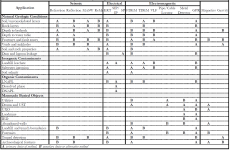
ASTM Standard D6429 Standard Guide for Selecting Surface Geophysical Methods suggests that Electrical Resistivity Tomography (ERT), gravity, and ground penetrating radar are the preferred methods for void detection. Which method your select depends on the target size, depth, and geologic material properties. For drug tunnel detection on the USA/Mexico border we used a number of methods, but you need to realize that a drug tunnel while a void at depth has other properties that can make it a better target than a mostly air filled cavity. Drug tunnels, or any tunnel for that matter, have to cross some boundary. The boundary can be a border, it can be the fence line of a military base or prison, or any other border. Typically the tunnel is perpendicular to the border to minimize the tunnel length. Drug tunnels usually have electrical wiring for lights or ventilation, they may have pipe systems to remove water, they may have other infrastructure. All of these pieces of infrastructure can be a better target than the air filled void. The tunnels also need to be dug, so we can listen for the digging sounds and locate them. We often used passive seismic arrays to locate the active digging, or active seismic arrays to locate the existing tunnels. As you can see from the table, seismic methods are a B and not an A for ideal method, but they often worked in these specific locations.

So, the general answer is that there are a lot of methods that may work but they are all site dependent.

If you watch the TV show I was on, I did an ERT survey to locate a cave about 100 ft below the ground surface.

A&E Television Networks, LLC
The History Channel
Lost Gold of the Aztecs, A Hidden Chamber S01E06
Episode aired Tuesday, May 10, 2022 at 10/9c
https://www.history.com/shows/lost-gold-of-the-aztecs

GPR can penetrate to 30 m (~100 ft), but usually won't due to the electrical conductivity of the soil. Also, the units that can image that deep are lower frequency systems (< 100 MHz center frequency) so have lower resolution. Using my ImpulseRadar CrossOver CO1760 GPR unit (170 & 600 MHz frequencies) I have penetrated to 15 m (~50 ft) at a few sites.

GPR penetration is affected by the electrical conductivity of the soil. This is the material property that controls attenuation. Density has nothing to do with it. Generally, wetter soils or rocks have higher electrical conductivity and therefor higher attenuation. But, I can use GPR on a freshwater lake to do bathymetry and map the bottom of the lake and materials beneath the bottom.

So in summary, if you have low attenuation at a site then GPR is the best method. If you have high attenuation, then GPR may not work at all and you will need to pick another method.
 

Attachments

  • ASTM Standard D6429 Table.png
    ASTM Standard D6429 Table.png
    104.8 KB · Views: 3
Thanks a million for information a real crash course for me. So forgive for any stupid questions from me as old Crow needs to get his head around it.

The location I am thinking of is not in United States. The location is volcanic in origin. Near the site is a magnetic anomaly. We assumes to be a volcanic vent? The location has central volcanic ridge c. 2 km long, surrounded by low coral flats with shallow hypersaline lagoons that are surrounded in turn by an outer lagoon and barrier reef.

The location is covered by thick jungle. Not practical place for GPR. No flat ground or open. There is intermittent spring so some moisture in the rock above sea level depending on season.

The soil type varies between calcareous, alluvial, and lateritic. Other soil types Debris at the foot of cliffs, Excellent quality soil that is well suited to tree crops, Colluvial soils, Coastal-plain soils, and Soils with impeded drainage. Moisture content varies due season fluctuation. There is no flowing fresh water streams. yet brackish water pools appear during wet season.

The following rock structure of the location below.

Bassalt
A mafite or basaltoid containing mostly calcic plagioclase, clinopyroxene +/- olivine, orthopyroxene, foids, oxides and rarely quartz.

A general term for fine-grained, mafic (dark-colored) igneous rocks, commonly extrusive (volcanic) but locally intrusive (e.g., as dikes or pipes), composed chiefly of plagioclase and clinopyroxene; the fine-grained equivalent of gabbro. Olivine and iron-titanium oxides are very common and nepheline, orthopyroxene, or quartz may be present. Adj. basaltic.

Basanite Tephritic rocks (fine grained, very silica-poor, basaltic rocks), with felsics comprising 10-60% foids (typically nepheline) and alkali feldspar/total feldspar <10%, >10% olivine. Tephrite is very similar but contains little or no olivine. Basalt is similar but contains little or no foids. The rock usually comprises mostly fine grained calcic plagioclase, clinopyroxene ( mostly augite), foids and olivine (typically as phenocrysts); it may have a glassy groundmass. Not to be confused with bassanite, the mineral, or basanite (chert), the black chert.

Hawaiite A term originally defined as a variety of olivine-bearing basalt in which the normative plagioclase is oligoclase or andesine. A sodium-rich trachybasalt where (Na2O-2)>K2O. They are dark coloured volcanic rocks usually described as basalt without chemical analysis.

Mugearite: A volcanic rock, often exhibiting flow texture, containing small phenocrysts of olivine, augite and magnetite in a matrix of oligoclase, augite and magnetite with interstitial alkali feldspar. Now defined chemically as the sodic variety of basaltic trachyandesite where (Na2O-2)>K2O. Usually described visually as a basaltic rock. Tephritic rocks, with felsics comprising 10-60% foids and alkali feldspar/total feldspar <10%, and <10% olivine.

Nepheline-tephrite: A nepheline rich tephrite.A group of fine grained, mafic igneous rocks, generally extrusive, of basaltic character, primarily composed of calcic plagioclase, augite, and feldspathoids (typically nepheline), with little or no alkali feldspar or olivine; also, any member of that group; the extrusive equivalent of theralite. With the addition of olivine, the rock would be called a basanite. With decreasing feldspathoids, it grades into alkaline basalt; with increasing feldspathoids, it grades into foidite.

Other factors with basalt. The amount of water in basalt can significantly affect its conductivity. For example, hydrous basalt melts with water contents above 6% have a similar conductivity to carbonatites in the mantle Carbon dioxide Dissolved carbon dioxide in basaltic melts doesn't have a noticeable effect on conductivity unless the concentration is very highSolid basalt samples are better conductors than powdered basalt samples. This is because the crystals in solid samples have better contact with each other.

So is it correct to assume a GPR would work effectively in such geological site in regards to the above mentioned factors? A GPR can map the geometry of lava tubes by detecting the strong reflection of radar pulses at the interface between the void and the rock?

Crow
 

Top Member Reactions

Users who are viewing this thread

Back
Top