Midden-marauder
Sr. Member
- Dec 10, 2023
- 377
- 640
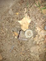
I don't know if we have any surveyors active here but I have discovered something strange on our property. The land we live on is about an acre give or take, I've seen the old survey maps from the original deed from the 50s and it doesn't appear that much has changed in terms of the property layout. Prior to the subdivision of the area it was part of a larger property which based on a 1935 aerial photo was essentially a wooded spot with no visible structures surrounded by agricultural lands. I've found now 3 L shaped pins countersunk about 4" smack in the middle of the property with no apparent relationship to the corners of the original survey nor indeed with any obvious relationship to the existing structures. When property surveys are done are additional points marked beyond the corners of the property? I've found other pins in locations corresponding to current survey info based on Google maps but these other pins I've found don't seem connected to that survey. The ones I've found are within 20' of each other in a roughly rectangular arrangement, there may be more I haven't found yet but it's a right head scratcher. Anyone here who could possibly shed some light on this? I've been researching this piece of land fairly deeply but there's no apparent link to this discovery, these old iron pins don't seem to relate to anything I've found.


