PLZ help me with figuring out township quarter sections!

gold chick

Full Member
Dec 28, 2019
106
176
Texas Gulf Coast
Detector(s) used
Garrett AT Pro
Primary Interest:
Metal Detecting
So, I cannot figure out how to read these dang quarter sections.

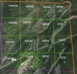
Here, I have quarter sections:

Quarter Sections.JPG

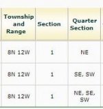
Ok, and here are my quarters:

Township Quarters.JPG

So, NE was easy enough to figure out, the entire NE section is claimed and the acres match the claim size (160 acres).

But, I cannot figure out SE,SW (80 acre claim) and I most definitely cannot figure out NE,SE,SW (120 acre claim) is!!!

To me, it seems like it could be quite a few combinations of quarters. At first, it seems easy, but then I get confused!

If you can help me figure this out, it will save me a boatload of money as I won't have to pay for access at the records office! They want to charge me $5 per HOUR just to access claims records online. No, I won't pay you $5 per hour for helping me figure it out! :dontknow:
 

Not sure what you want.
You could start at the point you want,
figure out what quarter of section that is,
and work to the section of the Township...,
or in reverse....
To make things more interesting, you could narrow it down by
quarter of a quarter section....
I have seen locational references to North half or South Half sections, too...!
Anyway, note that references are from smallest to bigger (eg the NE of the SE quarter section)
There! Now you are officially confused...!
 

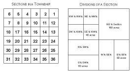
They did make it difficult because they have quartered off 1 giant plot into 1/4s. But if you look how I have it wrote out it will help you understand what they have done. Each quarter has it's own nw, sw, ne, se. The nwnw is the northwest corner of northwest plot, the southwest corner of northeast plot and so on. 20200203_124544.jpg
 

Not knowng what the scale of the map/aerial image is makes it tough. How many acres or cubic feet/yards/miles are each of the individual squares?

Four blocks of four squares each. The prefix is where in the 2x2 section the individual square is.

Prefix NW (North West) Suffix NW (North West) is the upper left corner. Beside that is NE (North East) of the NW (North West) grid section.
 

Last edited:
So each square is 40 acres.

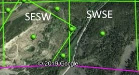
The quarter section that is called SE, SW would be this? The BLM says the claim is 80 acres...

SESW.JPG
 

One "section" is 640 acres in NY State. I don't know if that is universal.

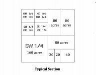
But your 16 squares are one section. So one quarter section would be any four squares. The "NE" quarter section would be the squares labeled "NWNE+NENE+SWNE+SENE"
 

So then what would NE, SE, SW be? Its a 120 acre claim, what squares would those cover?
 

Can you show more of that table? It may be costly for us to guess for you as to how "they" define the map key.

Just going by that limited view of the chart:

If SE = 1/4 section (160 acres)

SE, SW would be two quarter sections (320 acres)

and NE, SE, SW would be three quarter sections (480 acres)
 

So this is all I got, from BLM:

township.jpg

Then I plug this info into the Earthpoint website: Township and Range Search By Description

And it gives me that grid which comes up on Google Earth.

I just don't think the BLM gives me enough info to properly plot the claims, it seems.

NE, SE, SW is a 120 acre plot, but it doesn't seem to be enough info. I just can't figure it out.
 

So then what would NE, SE, SW be? Its a 120 acre claim, what squares would those cover?


The report is simply telling you which quarter sections the claim falls in.
It doesn't mean the entire 1/4 section is claimed.

So you could have a claim that is 40 acres that show's NE, SE
Or it could be 160 acres..then to throw you off, it could be more than 160 acres.

Sections come in all different sizes and shapes. They are rarely a perfect square, 1 mile x 1 mile.

It would be good practice to learn how to plot the NE 1/4, of the SE 1/4, of the SW 1/4, of section ##, township ##%, Range ###, ## Meridian. But that is not what that table is telling you as far as I know.

If BLM provided sufficient info, Landmatters would have it.
You have to go to the recorders office and read the location notice. It's not an easy chore. Very similar to title searches.
 

Last edited:
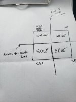
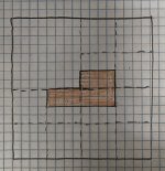
B883E3DB-BBF9-401C-9393-DBFBB9980D27.jpeg

Theoretically this could be a 50 acre claim which BLM would report as NE, SW, SE

Lots of room for other claims.
 

Legal description you get at the recorders office would be

The South 1/2, of the Southwest 1/4, of the Northeast 1/4, and the North 1/2, of the Northwest 1/4, of the Southwest 1/4, and the North 1/2, of the Northeast 1/4, of the Southwest 1/4, of Section ##..township, range, meridian..

Sometimes shortened to read S1/2 of SW1/4 of NE1/4, and N1/2 of NW1/4 of SW 1/4, and N1/2 of NE1/4 of SW1/4, of section ###
 

Last edited:
Why don't you just get a plat book of your county. It shows all the property lines and the landowners. We get ours at the Farm Bureau. They cost $10 or so. Less confusing than what you are doing. Gary
 

The report is simply telling you which quarter sections the claim falls in.
It doesn't mean the entire 1/4 section is claimed.

So you could have a claim that is 40 acres that show's NE, SE
Or it could be 160 acres..then to throw you off, it could be more than 160 acres.

Sections come in all different sizes and shapes. They are rarely a perfect square, 1 mile x 1 mile.

It would be good practice to learn how to plot the NE 1/4, of the SE 1/4, of the SW 1/4, of section ##, township ##%, Range ###, ## Meridian. But that is not what that table is telling you as far as I know.

If BLM provided sufficient info, Landmatters would have it.
You have to go to the recorders office and read the location notice. It's not an easy chore. Very similar to title searches.

Yes, this is what I suspected. I was hoping to not have to deal with recorders office (namely paying $5 an hour for viewing docs) but that is exactly what I will have to do.

I thought maybe I was missing something.

The map you drew is very helpful, that is what I was thinking it could be; obviously the shape of the claim could change within those three quadrant.

I will have to do my due diligence, then!
 

It seems like a cruddy system, but if you think about it, they have geographically indexed every claim in the country right down to the quarter section!

Then you throw in the fact that many people are very confused and their claim markers on the ground do not match their legal description.

The difficulty leads to trespass. This is why I believe the majority of the beginners wanting to go out a pan for gold or go snipe some bedrock end up on someone’s claim that isn’t well posted on the ground.

This is why I typically stick to the hills.
 

Looks like you have 1 square mile (640 acs.) in the total picture area. Next, divide 640 by 16 squares = those are 40 acs. each.
That diagonal piece is someone who cut that out of the original area for whatever reason to drill/prospect/mine, ect. and has a separate description assigned to it.
Is that overlay of lines from the county GIS?
Or did you overlay the lines while you were in google maps?
You can right click on any of the corners on google maps and scroll down to What's here? and get the gps coordinate. Google earth displays coords as you move mouse around.
Then go into the field with your gps on your phone and walk to the corners, and if you see markers from someone else you can gauge the accuracy of the gps.
Jon 8-) :cat: :occasion14: :headbang: sections.jpg typical_section.jpg
 

A book I use has all of the surveying terms used by ASCE and mapping. Like any language, surveying has it's own.
Definitions of Surveying and Associated TermsIt was prepared and published for the surveying and mapping industry.
A lot of terms we use regularly are often not well defined in our heads so this book is a glossary of technical terms but it
also helps define terms we commonly run into with other areas. Like the last time you wanted to know what a cusp point was.....:)
If anyone need to understand land issues, Like in court, knowing the language is a good start.
 

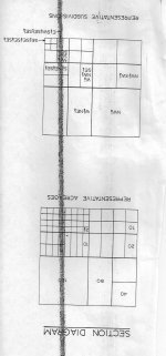
This should help more, than my last post!
Sorry!
Sections.jpg
 

Top Member Reactions

Users who are viewing this thread

Back
Top