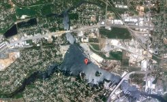
Please help with this map...

pccvanwilder

Jr. Member
Nov 22, 2009
28
0
florida panhandle
Detector(s) used
tesoro

Attachments

  • bc.JPG
    bc.JPG
    135.8 KB · Views: 507
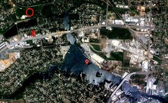
Hello pccvanwilder, I've found 2 places of interest. Red X is where I get gold/silver/coins, looks on your map to be in or close to a populated area. The red circle, artifacts, along with some gold/silver/coins too.
 

Attachments

  • bc-FL_pccvanwilder.jpg
    bc-FL_pccvanwilder.jpg
    217.4 KB · Views: 429
That is VERY interesting. It goes right along with what has already been found there and the history that area has. I know very little at all about map dowsing, but I am curious if you feel the stuff is in water or on land and how deep. Again thank you VERY much for taking the time to give me some feedback. :blob7:
 

pccvanwilder said:
That is VERY interesting. It goes right along with what has already been found there and the history that area has. I know very little at all about map dowsing, but I am curious if you feel the stuff is in water or on land and how deep. Again thank you VERY much for taking the time to give me some feedback. :blob7:
I thought the X could be on or close to land.
 

Hello, pccvanwilder,
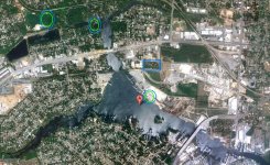
Dowsing agreed with Red_deserts north location regarding a mix of gold/silver coins as shown here in a green/blue circle.
Dowsing also revealed 2 other gold/silver mix of coins as shown in a green/blue circle.
Blue rectangle area: Individual silver coins.
I did'nt get a solid depth. This often happens the further out from the center of the picture the locations are and how far out the picture is and/or the sharpness of the photograph. If you'd like, try and post a clear, sharp close up picture of Red's and my dowsed locations and maybe a solid depth will come through. The closer you can get in without blurring, the better the pinpoint of the location will be.
Thanks for posting your picture,
Jon
 

Attachments

  • bcdowsed.jpg
    bcdowsed.jpg
    137.2 KB · Views: 228
First of all thank you so much for taking the time to do this for me. I do not understand dowsing very much, and have never really tried to map dowse, but I have done it using L rods and know for a fact there is some validity to it. As far as the spots I have some good news and bad news. The bad news is that the spot you both agreed on in the upper left hand corner is a rock quarry (sp?) that has filled up with water. It seems to be VERY deep... and there are stories of locals drowning in it after falling in because of the way the sides were cut and there being no way to climb out. The bottom spot you marked is now a marina... and searching there will probably be more of a hassle than it is worth.

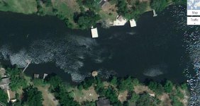
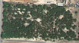
Now for the positive news. The spot you marked in a blue rectangle for silver coins has indeed provided cobs in the past. Maybe we need to hit that again and keep looking some more. I am going to provide a close up of the other area you circled... near the joining point of the different waterways. If you are able to provide any other information about it that would be great. The good news about that spot is my 6th sense has always told me to look more in that particular area anyway, so you have just confirmed that feeling for me. The first picture is the area you marked where the different branches of water come together. The second is a close up of the cob area.
 

Attachments

  • bc close up.JPG
    bc close up.JPG
    78.4 KB · Views: 245
  • cob area - bc.JPG
    cob area - bc.JPG
    76.6 KB · Views: 258
Oh, we have a rock quarry my area, over a 2 hour drive south of here. It filled up with water so quickly, all the quarry equipment is still on the pond bottom. Now they just use it for scuba diving groups, no fishing allowed. There definitely would be artifacts, tools, etc.
 

Hi pccvanwilder,
Can you post another bc closeup waterway picture zoomed out a little to show more area north and south of the waterway?
Thanks,
Jon
 

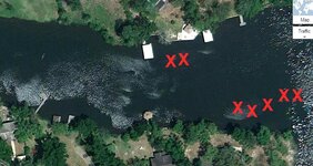
I might as well post what I'd got for the waterway, didn't do the cob area yet. Might be some coins in there, but red Xs for any kind of signal, whether worth it or not. Some spots could be just debris.
 

Attachments

  • bc close up-pccvanwilder.JPG
    bc close up-pccvanwilder.JPG
    96.2 KB · Views: 354
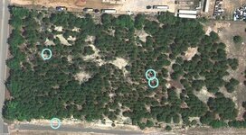
Blue circles where I get a silver attraction.
 

Attachments

  • cob area - bc-pccvanwilder.JPG
    cob area - bc-pccvanwilder.JPG
    87.5 KB · Views: 369
Hi pccvanwilder,
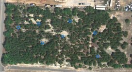
Dowsing revealed:
Blue circled areas: Silver attraction.
Dowsing also agreed with Red_deserts locations, especially the north circled area of the eastern 2 circles. Great dowsing Red_desert!
Thanks for posting your picture,
Jon
 

Attachments

  • cob area - bcdowsed.jpg
    cob area - bcdowsed.jpg
    77.2 KB · Views: 235
Yes Jon, I think there is more. After marking the circle in the bottom left edge, checking again got another response close to it.
 

Top Member Reactions

Users who are viewing this thread

Back
Top