- Feb 3, 2009
- 41,159
- 157,134
- 🥇 Banner finds
- 1
- Detector(s) used
- Deus, Deus 2, Minelab 3030, E-Trac,
- Primary Interest:
- Relic Hunting
They say a picture is worth a thousand words, and in many cases it is true. In researching old historical altas/mapping/artist sketches and the actual lay of the land is sometimes totally different from what one views in the written text. This can throw off a person when trying to determine the actual locations of a site, the topography of the land vs a sketch will/could be nothing of the same.
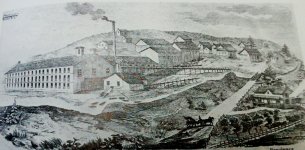
Here is a townsite/mill site that I had hunted for years, now I had not seen the historical sketching until after my years of hunting there had ended there.
Where the mill sat actually falls way from the road where the horse and carriage is in the photo.
This is where the stream runs, now in the sketch it looks like a sizeable water course-yet in real life it's not too wide and a few feet deep.


Now here are the 2 goggle earth street shots
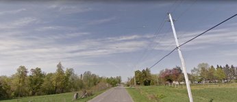
The first shot is where the artist sketched the scene, and the house on the right is the one on the sketch.

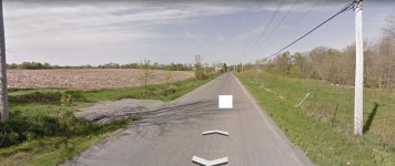
Second shot of the field is where the office sat in the sketch looking out onto the hill and other buildings.

Notice the difference in the topography? No hill just a slight rise to the field.
Now it was said when this brought up in discussion the consensus was that it would be hard to sketch a photo of a plain showing all the town-so the artist will put them on a hill.
Just thought I'd do a little example for the folks that have a struggle in mapping/reading a text/book and the actual lay of the land when they get there.
Best of luck on the research of your next keeper.
Here is a townsite/mill site that I had hunted for years, now I had not seen the historical sketching until after my years of hunting there had ended there.
Where the mill sat actually falls way from the road where the horse and carriage is in the photo.
This is where the stream runs, now in the sketch it looks like a sizeable water course-yet in real life it's not too wide and a few feet deep.

Now here are the 2 goggle earth street shots
The first shot is where the artist sketched the scene, and the house on the right is the one on the sketch.

Second shot of the field is where the office sat in the sketch looking out onto the hill and other buildings.

Notice the difference in the topography? No hill just a slight rise to the field.
Now it was said when this brought up in discussion the consensus was that it would be hard to sketch a photo of a plain showing all the town-so the artist will put them on a hill.
Just thought I'd do a little example for the folks that have a struggle in mapping/reading a text/book and the actual lay of the land when they get there.
Best of luck on the research of your next keeper.
Last edited:


