Not Sure if I am Reading this Right

cambria09

Bronze Member
Jun 10, 2012
1,838
3,840
Florida
Detector(s) used
Mine Lab Sovereign Elite, Mine Lab Etrac, Garrett ATMax
Primary Interest:
All Treasure Hunting
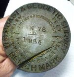
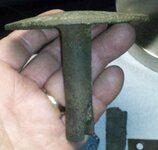
Howdy All. Found this tonite at a c1920 curb strip. For the record I did not destroy public property to recover this item. It was lying loose on its side about 3-IN down and unattached to anything so I should be safe from fine or imprisonment.

I am assuming that the "N" indicated North and the "78" indicated its elevation in feet above mean sea level based on its original and location respectively? (The elevation of where I dug it is about 60-FT above seal level.)

The "1934" engraving is the year it was placed?

Let me know what you think and good luck out there. Thanks.

C9
 

Attachments

  • Ch RR Ch SH Meth Ch Bi CS 0831 090412 A Bnch Mrk.jpg
    Ch RR Ch SH Meth Ch Bi CS 0831 090412 A Bnch Mrk.jpg
    386.3 KB · Views: 127
  • Ch RR Ch SH Meth Ch Bi CS 0831 090412 Side Bnch Mrk.jpg
    Ch RR Ch SH Meth Ch Bi CS 0831 090412 Side Bnch Mrk.jpg
    173.1 KB · Views: 138
Yep, benchmark shows elevation. Horizontal markers have a triangle in the center.
The 250$ fine was established in 1896 and has not changed but imprisonment went from 100 days to 6 months in 1909.
Also there is a 25$ reward for informers following the conviction of anyone tampering with the markers.
And sorry but i really needed 25$, so the survey police are on there way.:laughing7:
 

Upvote 0
LOL ! from the slice in it, looks like a dozer pulled it out awhile ago.
My guess most benchmarks have been forgotten & destroyed
during construction Projects over the years.

you can do a search here Geocaching > Benchmark Hunting to see if it is a known benchmark,
But I sort of think this one has been lost for many years.

Sorry I have no idea who you could contact to see if they wish to re plant it properly.

gallery
http://www.geocaching.com/mark/gallery.aspx
 

Last edited:
Upvote 0
Jeff, most benchmarks by USCGS are not lost. They are on record somewhere and if doing Gvt. work are considered good. I've had to chop roots of trees to recover them. I always told dozer operators that when I go to the BIG WOODS I always take a few stakes & a roll of ribbon. If I become lost, I plant a few stakes in line w/ ribbon on top & sit down to have a smoke. I figure before long a dozer operator will come along to run the stakes over & I can follow his trail out.
 

Upvote 0
the form/place to say marker is found

Mark Recovery Entry
Mark Recovery Entry
Photo Submission Guidelines
National Geodetic Survey - Photo Submission Guidelines

National Geodetic Survey - Home
NGS Home

Looks like it's considerd destroyed.

email her a pic & wait to see if they want it.
Just explain it wasn't in it's socket & no idea where it goes


Note: For destroyed marks do one of the following:

1) If you have found the actual marker separated from its setting, you can report the point as destroyed. To do so please send the report on the destroyed mark as an email to Deb Brown ([email protected]). If you send this email, please do not submit the current form, Deb Brown will submit the report for you. In addition, please submit proof of the mark's destruction via actual disk, rubbing, photo, or digital picture (preferred) to Deb Brown:

Deb Brown, N/NGS143
National Geodetic Survey, NOAA
1315 East West Highway
Silver Spring, MD 20910

2) If you did not find the actual marker, then you should enter notes concerning evidence of its possible destruction as text records and select "Not recovered, not found" as the condition of mark.
 

Last edited:
Upvote 0

Top Member Reactions

Users who are viewing this thread

Back
Top