pcolaboy
Hero Member
Have any of you checked out the hi-res imagery available on Microsoft's Virtual Earth lately? Forget Google Earth.
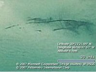
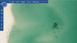
Maybe I'm slow getting on the bandwagon or the imagery has just now been made available for my area. Check out the shots of this wreck I found off Santa Rosa Island. This wreck has been known to exist for years but it will go through several years of being buried by the sand then uncovered by storms at certain times.

North is Up(note the scale)

North is Left
Keep in mind to get the hi-res imagery, you have to choose the Bird's Eye selection. It's MUCH easier if you go ahead and download the 3D add-on which lets you pan out to a wider angle making the imagery selection easier.
Enjoy,
Pcolaboy
Maybe I'm slow getting on the bandwagon or the imagery has just now been made available for my area. Check out the shots of this wreck I found off Santa Rosa Island. This wreck has been known to exist for years but it will go through several years of being buried by the sand then uncovered by storms at certain times.

North is Up(note the scale)

North is Left
Keep in mind to get the hi-res imagery, you have to choose the Bird's Eye selection. It's MUCH easier if you go ahead and download the 3D add-on which lets you pan out to a wider angle making the imagery selection easier.
Enjoy,
Pcolaboy


 In fact I'm currently checking out your area and the hi-res is in most of your coastal areas as well.


