Need a map overlay

1320

Silver Member
Dec 10, 2004
3,436
2,311
East Central Kentucky

Attachments

  • Aarons_Run Large.jpg
    Aarons_Run Large.jpg
    2.2 MB · Views: 156
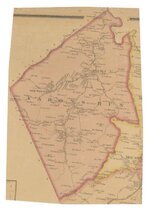
Did an overlay, but you must remember that map making in the 1850's was not on par with what we have today.

Very happy to provide it for google earth if you wish.

I work on "ground truthing" ... that is working with very old maps and locating old Indian trails in my search for Trail Marker Trees in the past several years.
 

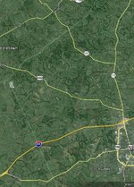
Small, but you'll get the idea. Using your photo editor, open the base_map.jpg, and the overlay_map.jpg files (restrictions here won't allow PSP images with layers).

Copy the "overlay_map.jg" image in the photo editor then paste it as a "New layer" on top of the "base_map.jpg" image. Now you can use the visibility slider to adjust the visibility of the top image and you will see the relationship of the old map (after a lot of fitting and squeezing) to the actual portion of the county.

Roads change, move or disappear. Rivers and creeks change course. Those edges of the map are not going to be correct in some cases, as with some of the internal roads.

If this helps (other than the small size), I can enlarge the image to match your original old map.

base_map.jpgoverlay_map.jpg
 

Are you sure that's right?
The overlay map registration looks a little off to me.

Admittedly, this is not my area of expertise, but I played with this for about 10 minutes before going to bed last night.
My attempt (result) is attached as a Google Earth *.kmz file.
Just open it in Google Earth.

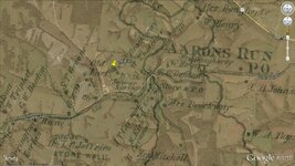
Specifically, I believe the "Old Fort" is now a clump of trees. (See attached *.kmz)

View attachment Old Fort Overlay.kmz

Regardless, hope you find some nice coins & relics!!
Good luck!
 

Are you sure that's right?
The overlay map registration looks a little off to me.

Admittedly, this is not my area of expertise, but I played with this for about 10 minutes before going to bed last night.
My attempt (result) is attached as a Google Earth *.kmz file.
Just open it in Google Earth.

Specifically, I believe the "Old Fort" is now a clump of trees. (See attached *.kmz)

View attachment 1215380

Regardless, hope you find some nice coins & relics!!
Good luck!

Correct, the one that I posted was to let Chadeaux know that I was able to successfully make an overlay, he's been helping me via PM's. I spent about 30 minutes, sizing, resizing, moving, etc., and now I too have the Fort in the woods, inside the curve of the gravel driveway. Is that were you have it? I can't open the file that you attached....I'd love to see what you came up with and thanks for helping out...much appreciated!
 

Old Fort Overlay

Do you have Google Earth installed?
If so, you should be able to just save the file to your PC, and then double-click it.
It should open in GE automatically and zoom in to the area of interest.

Anyway, here's a JPG.
I put a yellow push-pin on the Old Fort.
GPS = 38.12882, -84.00847

Old Fort.jpg

Again, good hunting!!
Wish I were with you (and not out "hunting" for a new fridge today!)
Ours is on the blink again, and time to replace!!
 

Do you have Google Earth installed?
If so, you should be able to just save the file to your PC, and then double-click it.
It should open in GE automatically and zoom in to the area of interest.

Anyway, here's a JPG.
I put a yellow push-pin on the Old Fort.
GPS = 38.12882, -84.00847

View attachment 1215409

Again, good hunting!!
Wish I were with you (and not out "hunting" for a new fridge today!)
Ours is on the blink again, and time to replace!!

Man, that's perfect, thank you! I don't have GE, can't get it here at work...lol. I tried to use winzip to open it but no luck yet.
 

"Specifically, I believe the "Old Fort" is now a clump of trees."

Man, that circular shaped clump of trees is really out of place, looks very peculiar.....hmmmmm. Time to hit it (Sunday).
 

Top Member Reactions

Users who are viewing this thread

Back
Top