Mountain side claim questions

blackchipjim

Full Member
Dec 25, 2016
213
194
ohio
Detector(s) used
bounty hunter time ranger
Primary Interest:
All Treasure Hunting
I may be thinking too long and too wrong on this claim. Say I have found a prospect on the side of rather steep hill/mountain. The vein is an outcrop on one side of the mountain and appears on the other side of this mountain. In theory it is well over a standard lode claim and might not be the same vein/outcrop on the other side. This is the question do I file a discovery on both outcrops and file claims that would include land between them from one end to the other?
 

Upvote 0
I may be thinking too long and too wrong on this claim. Say I have found a prospect on the side of rather steep hill/mountain. The vein is an outcrop on one side of the mountain and appears on the other side of this mountain. In theory it is well over a standard lode claim and might not be the same vein/outcrop on the other side. This is the question do I file a discovery on both outcrops and file claims that would include land between them from one end to the other?
This can be a good idea. Money and time invested are other things to look at as well if the values are not there. The values / "Mineral deposit" have to be in the "Rock in place / vein" in order to make the "Discovery".
 

You can file on both if you like but one or the other would be good enough. As long as you can prove that the lode apexed (or outcropped) on your claim you have extralateral rights to it underground even if it is under someone else's claim UNLESS they have a shaft or adit into the same vein.

Now with extralateral rights the ends of your claim MUST be parallel to qualify for the extralateral rights.

You can also file a lode claim over a placer claim WITH the claim owners permission. It pays to be neighborly and helpful to neighboring claim owners and giving them a few percent of the take usually helps with the permission aspect.
 

More on the mountain side claim aspect. On vertical grades or near vertical how does one set the claims bounds? I know you guys think where I come up with this chit but it may where I want to prospect.
 

The survey of a mining claim may include several contiguous locations owned in common, but in conformity with statutory (Lode lines and End lines limits) requirements such survey record will distinguish the several locations and exhibit the boundaries of each. Usually a "Mineral Surveyor" will do this. This can help with 'extralateral rights'.
 

More on the mountain side claim aspect. On vertical grades or near vertical how does one set the claims bounds? I know you guys think where I come up with this chit but it may where I want to prospect.
A "Corner Accessories" and "Memorials" is used for this.
 

Last edited:
More on the mountain side claim aspect. On vertical grades or near vertical how does one set the claims bounds? I know you guys think where I come up with this chit but it may where I want to prospect.

Clay Diggins can back me up on this but you don’t measure the 600x1500 by walking up the side of the hill.

It’s measured as you would see the terrain if above the ground looking down.

I’m sure this is true with placer claims pretty sure with lode too.

Barry?
 

Clay Diggins can back me up on this but you don’t measure the 600x1500 by walking up the side of the hill.

It’s measured as you would see the terrain if above the ground looking down.

I’m sure this is true with placer claims pretty sure with lode too.

Barry?
Good point as some may not know this. In the older days a steel tape also known as a type of "Chain" was stretched over the ground. Today lasers are often used. The same is also used sub-surface in any type of opening.
Many people today will use GPS Way points to locate the "Surface Location" and file a standard acre sized "Claim".
 

Last edited:
You can file on both if you like but one or the other would be good enough. As long as you can prove that the lode apexed (or outcropped) on your claim you have extralateral rights to it underground even if it is under someone else's claim UNLESS they have a shaft or adit into the same vein.

Now with extralateral rights the ends of your claim MUST be parallel to qualify for the extralateral rights.

You can also file a lode claim over a placer claim WITH the claim owners permission. It pays to be neighborly and helpful to neighboring claim owners and giving them a few percent of the take usually helps with the permission aspect.

I believe your last line is incorrect. No one can file a placer claim over an existing lode claim. However, a placer claim Grantee is the only person that can file a lode claim over his existing placer claim. As long as the lode claim is initially located outside the boundary of the placer claim, it can pass beneath it.
 

Last edited:
Considering the last thread where questions like this were asked was locked .... because misinformation was pointed out. And someone didn't like that for some silly reason. I don't know how many answers these questions are gonna get anymore.

Considering there is already some misinformation.....
 

Regarding measurements, all slope distances are reduced to horizontal distances when describing land boundaries.

A long time ago, when I first began land surveying, I stretched many a "chain" to measure boundary lines. Many things were taken into consideration with chain measurements. The chains were typically 300' long and each chain, while very high quality, had stretch characteristics unique to it, which were accounted for.

Measurements were taken with the chain clear of the ground and any vegetation along the traverse line. Generally a chainman would drag the chain out slightly behind the brushers clearing the line, also helping with the clearing and making sure the back path to the instrument at the last traverse station is "clear".

It was very important to have a smart lead chainman. Upon approaching 300' from the last station or a break in the terrain, a suitable location, close to "line", was selected for the next station. This location would need to be on solid ground, suitable for setting up the tripod and theodolite and advantageous to seeing a "long" course ahead to the next possible station.

Once the new hub (station) was set, the chain was cleared from any brush, limbs, etc by firm but at the same time gentle whipping up and down. When cleared, the instrument man would take a truly sturdy stance by the "gun" (theodolite), raising his end of the chain to an even one foot mark at a vertical and horizontal mark at an axis of the scope which was pointed at the next station.

At the other end, the lead chainman would begin to take the slack out of the chain in a steady manner of increasing effort while suspending a plumb bob and string over the chain. At this end of the chain, beyond the zero mark, is another foot which has raised increments divided into tenths and hundredths of a foot.

The chainman increases the pull on the chain until the instrument man, holding on an even foot at the other end, hollers "mark" or whatever they are used to. The chainman is sliding the plumb bob and string along this extra foot to exactly over the hub and tack, hollering back when he has a good set (measure). The chainman immediately notes the value of this additional distance and the instrument man notes his foot mark. The two combine for a total distance to this course. This distance was then, later in camp or at the office, reduced to horizontal distance along with the workup of the horizontal angles of the traverse. When I first started surveying we didn't have calculators and computers. We used angle reduction tables in book form to reduce raw field angles. All measurements were recorded if a waterproof field book. It was a cardinal sin to loose one of these field books. Really!!!

Depending on the order (accuracy required) of the survey, more elements are incorporated. Spring balance on the ends of the chain, temperature and atmospheric pressure correction etc.

I know this is kind of a long winded post about a basic question, but surveying in general, and the history of our Public Land Survey System, is really fascinating to anyone interested in this sort of study. The PLSS was a truly unique and well thought out government operation. There was great effort and honesty as well as great frauds in the surveying of our western lands.

Mike
 

Last edited:
Lode claims own all the valuable minerals within the bounds of the location.

1872 Mining Act:
That the locators of all mining locations heretofore made, or which shall hereafter be made, on any mineral vein...

shall have the exclusive right of possession and enjoyment of all the surface included within the lines of their locations, and of all veins, lodes, and ledges throughout their entire depth, the top or apex of which lies inside of such surface-lines extended downward vertically...

although such veins, lodes, or ledges may so far depart from a perpendicular in their course downward as to extend outside the vertical side-lines ...

Provided, That their right of possession to such outside parts of said veins or ledges shall be confined to such portions thereof as lie between vertical planes drawn downward as aforesaid, through the endlines of their locations.

To make this simple your lode claim

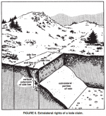
1. Has to be aligned along the long centerline with the strike of your discovery because you have no mineral rights beyond the parallel short side end lines. Here's a visual of how that works:
Extralateral.png

2. Your mineral rights are vertical (at right angles to a horizontal plane) to your endlines. They do not extend at right angles to the surface. Those mineral rights extend down to the center of the earth. This is true of both lode and placer claims.

3. Your mining claim, should be a maximum of 300 foot on either side of the centerline and 1500 feet along the strike. These measurements do not follow the surface but are calculated as an area at right angles to gravity.

A lode claim located on a steep hillside may appear, on the surface, to exceed those measurements but you are claiming the volume of minerals within the earth not the surface shape. If you locate your claim by surface measurement on a slope your claim will be for a lot fewer minerals than you are permitted to include.

Lode mining claims are located by metes and bounds (compass direction and distance). The angle of the slope is not a consideration in metes and bounds. Describe your claim as if it were seen as a regular shape directly from above not at right angles to the slope.

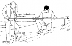
Here's a visual example of the correct way to measure survey distances on a slope:
Screen Shot 2018-04-06 at 10.19.55 AM.png

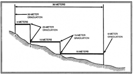
Of course two guys with a yardstick can't measure out the distance over 1,500 feet. Here's an example how surveyors accomplish accurate measurement over a distance on a slope:
MeasureSlope2.png

If you have modern accurate mapping software you might be able to avoid the distance measurements on the ground by placing monuments at the calculated corners and centerlines. Keep in mind eventually a paying deposit will need to be surveyed on the ground. Your computer mapped position will not match the actual ground survey results. That can lead to serious problems later if your location proves to be a rich strike. Get as accurate as you can when making a metes and bounds location.

I can't imagine a situation where a single location on one side of a mountain could lead to mineral rights on the other side of the mountain. If you have discovered the exposed apex of valuable lode minerals it is best to make a new location for each apex. You can't possibly know which vein exposure will take legal precedence before you mine. A lot of money has been made by lawyers arguing over extralateral rights but I've never known a miner who came out ahead by spending their mining time in court.

Heavy Pans
 

Last edited:
a person with permission to discover or one that has permission to prospect on a placer can locate a lode on a placer claim. it does not have to be the owner of the claim.

You can't prospect without permission.

A savvy club member can locate a lode on a club placer as long as the club hasn't taken the right away.

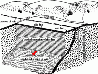
Also extra lateral rights extend only past the side lines not the end lines

extra lateral rights.gif
 

Regarding measurements, all slope distances are reduced to horizontal distances when describing land boundaries.

A long time ago, when I first began land surveying, I stretched many a "chain" to measure boundary lines. Many things were taken into consideration with chain measurements. The chains were typically 300' long and each chain, while very high quality, had stretch characteristics unique to it, which were accounted for.

Measurements were taken with the chain clear of the ground and any vegetation along the traverse line. Generally a chainman would drag the chain out slightly behind the brushers clearing the line, also helping with the clearing and making sure the back path to the instrument at the last traverse station is "clear".

It was very important to have a smart lead chainman. Upon approaching 300' from the last station or a break in the terrain, a suitable location, close to "line", was selected for the next station. This location would need to be on solid ground, suitable for setting up the tripod and theodolite and advantageous to seeing a "long" course ahead to the next possible station.

Once the new hub (station) was set, the chain was cleared from any brush, limbs, etc by firm but at the same time gentle whipping up and down. When cleared, the instrument man would take a truly sturdy stance by the "gun" (theodolite), raising his end of the chain to an even one foot mark at a vertical and horizontal mark at an axis of the scope which was pointed at the next station.

At the other end, the lead chainman would begin to take the slack out of the chain in a steady manner of increasing effort while suspending a plumb bob and string over the chain. At this end of the chain, beyond the zero mark, is another foot which has raised increments divided into tenths and hundredths of a foot.

The chainman increases the pull on the chain until the instrument man, holding on an even foot at the other end, hollers "mark" or whatever they are used to. The chainman is sliding the plumb bob and string along this extra foot to exactly over the hub and tack, hollering back when he has a good set (measure). The chainman immediately notes the value of this additional distance and the instrument man notes his foot mark. The two combine for a total distance to this course. This distance was then, later in camp or at the office, reduced to horizontal distance along with the workup of the horizontal angles of the traverse. When I first started surveying we didn't have calculators and computers. We used angle reduction tables in book form to reduce raw field angles. All measurements were recorded if a waterproof field book. It was a cardinal sin to loose one of these field books. Really!!!

Depending on the order (accuracy required) of the survey, more elements are incorporated. Spring balance on the ends of the chain, temperature and atmospheric pressure correction etc.

I know this is kind of a long winded post about a basic question, but surveying in general, and the history of our Public Land Survey System, is really fascinating to anyone interested in this sort of study. The PLSS was a truly unique and well thought out government operation. There was great effort and honesty as well as great frauds in the surveying of our western lands.

Mike

Excellent explanation Mike! Beat me to it. :thumbsup:

Thanks for sharing your experience. It's great to have someone with first hand knowledge on this forum. I share your fascination with the PLSS history and practice. It's a subject most prospectors would benefit from a greater knowledge of the process and intent.

Heavy Pans
 

I'm learning alot from you gentlemen and the diagrams give a clear picture of procedure. As I understand the answers when I'm going up a hill I have to make adjustments for the slope. The distance is not linear up the slope it is from the horizontal.Next question to clarify if I may. My claim is at the base of a 300 ft sheer, my claim starts there and is plotted up on top of the plateau correct.
 

a person with permission to discover or one that has permission to prospect on a placer can locate a lode on a placer claim. it does not have to be the owner of the claim.

You can't prospect without permission.

A savvy club member can locate a lode on a club placer as long as the club hasn't taken the right away.

Also extra lateral rights extend only past the side lines not the end lines

View attachment 1574441

Well said! Good points. :thumbsup:

The only way to locate any valid lode claim is to discover valuable minerals in place.

You can't locate a lode claim over a placer claim just because the placer owner gave you permission. You would need to obtain permission to prospect the placer claim and discover a valid lode deposit while prospecting. Once you discover the lode you don't need the permission of the placer claim owner to make a claim on your discovered lode.

The issue with "prospecting" clubs placer claims is poorly understood by most clubs. Even should the club restrict members from locating lode claims over the club's placers in their member rules (most don't) the discovery of a lode deposit by a member permitted to prospect the claim could lead to a valid lode claim located by that member. Club rules don't trump federal law. The placer owner doesn't have a right to prevent the location of a lode claim once they have allowed the locator to prospect the claim. That's why professional miners lease claims for mining specific minerals rather than allowing open prospecting for any minerals.

The owner of a valid mining location, whether lode or placer, has the right to the exclusive possession and enjoyment of all the surface included within the lines of the location. Once they allow that possession to be shared with a visiting prospector placer claims are opening themselves up to a valid challenge to their possession. The same is not true of lode claims. No placer can be located over a valid lode claim in any circumstance.

Heavy Pans
 

Last edited:
Ive told guys this. They just look at me funny and continue bleepin.
Thanks Clay.
Gt.....
 

"Metes-and-bounds surveys are required to define the boundaries of irregular tracts which are nonconformable to legal subdivision".
The survey procedure is similar for each type of claim, grant, or reservation having irregular boundaries.

The law prescribes the chain as the unit of linear measure for the survey of the public lands, and all returns of measurements are to be made in true horizontal distances, in miles, chain, and links.
 

Ive told guys this. They just look at me funny and continue bleepin.
Thanks Clay.
Gt.....


That's because high graders don't care about claim boundaries or the whys and hows that create them
 

Well Clay I am still completely puzzled by the fact that numerous Lode Claims in and around Rich Hill are simply laid out like 20 acre placers.....not the required way....(I am not sure if other miners have seen the same situation elsewhere). That said, it is known that such incorrect actions leads to another fact; that a placer can not be placed over an existing lode claim. So basically; these 20 acre lode claims, that may have been placed upon "club claims" at one time; remove the locations from placer locations; once the clubs lost the claims (for one reason or the other). While this thread has been very enlightening about the "how to" on lode claims there is a whole relevant issue as to "when they are done wrong"....what then?

Bejay
 

Top Member Reactions

Users who are viewing this thread

Back
Top