Mining Activity in Needle Canyon Near Terrapin Trail

skyhawk1251

Sr. Member
Nov 9, 2018
322
717
Kingman, AZ
Detector(s) used
Fisher Gold Bug Pro
Primary Interest:
Prospecting
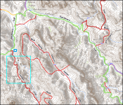
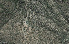
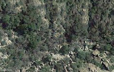
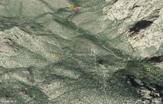
Here are some GE images of a mine dump in Needle Canyon near Terrapin Trail. On the topo map, I'm assuming that the mine is the one farthest south of the four marked on the map inside the box. I haven't yet spotted the other three mines. In the last GE image, I see a circular ground feature located at two o'clock from the mine dump. The circular feature has a large tree in its center.

001.png


002.png


004.png
 

Skyhawk,
Unless I’m looking at the wrong spot, it appears that the mine dump, with circular design at 2:00 and tree at center …: it seems to line up to the northern most of the 4 shown on the topo map snip.
Am I looking at the wrong spot?
 

I am seeing the mine dump located East side of Needle Canyon.
Edit: I can’t tell for sure, but maybe could be the 2nd mine furthest north shown in the rectangle?
 

Last edited:
Perhaps that mine dump is from the 2 mines right next to each other on the topo map….

Thanks for sharing :icon_thumright:
 

Here are some GE images of a mine dump in Needle Canyon near Terrapin Trail. On the topo map, I'm assuming that the mine is the one farthest south of the four marked on the map inside the box. I haven't yet spotted the other three mines. In the last GE image, I see a circular ground feature located at two o'clock from the mine dump. The circular feature has a large tree in its center.

View attachment 2028570

View attachment 2028571

View attachment 2028574

Actually, the spot you are referred to is out of the blue rectangle, and i marked it with a darker blue in your image.
This debris it's from Al Morrow tunnel/mine which he opened believing how had some connection with the LDM. Above that tunnel, on that small elongated hill, was the marked saguaro which was mentioned by Barry Storm in his book. Al's camp was just few yards from the tunnel to the canyon floor.
 

Attachments

  • 001.png
    001.png
    341.6 KB · Views: 79
Last edited:
Yep, good job markmar :icon_thumleft:
I can see it now too. :notworthy:
 

Last edited:
I saw some nice photos of Al Morrow here on T-Net.
The thread is locked, so I don’t know how to link the post, but it is
In Lost Dutchman Goldmine forum… (edit: forum is “The Lost Dutchman’s Mine”)
Thread is currently on page 20, called - Superstition People, Places & Things
Post number 4
 

Last edited:
I saw some nice photos of Al Morrow here on T-Net.
The thread is locked, so I don’t know ho to link the post, but it is
In Lost Dutchman Goldmine forum… (edit: forum is “The Lost Dutchman’s Mine”)
Thread is currently on page 20, called - Superstition People, Places & Things
Post number 4
https://www.treasurenet.com/threads/superstition-people-places-things.488482/

Yes, from what I have read, Al was a great guy. He was killed in that tunnel by a cave in. He never found something valuable in that tunnel and he used it more to store some goods. I believe his income was from the panning. Al had a map in his possession which showed how Waltz was panning gold just few yards west from the marked saguaro.
At the spot Waltz was panning, he was getting flakes from 8 gold mines which are in the surrounding area. None of these mines is depicted on the topo map. What are depicted, are modern days prospects which have not claimed any gold.
 

Last edited:
In the image below, I've marked the mine dump (yellow box) and the circular ground feature (red box). I'll continue scanning the area to see if I can find the other three mines that are shown on the topo map, although markmar is probably correct when he wrote that this dump is not one of the cluster of four mines, but is located north of the cluster. I'll do my scanning, keeping that thought in mind.

004.png
 

In the image below, I've marked the mine dump (yellow box) and the circular ground feature (red box). I'll continue scanning the area to see if I can find the other three mines that are shown on the topo map, although markmar is probably correct when he wrote that this dump is not one of the cluster of four mines, but is located north of the cluster. I'll do my scanning, keeping that thought in mind.

View attachment 2028652
The round shape it's not an arrastra. it's too large and the terrain it's too steep. The arrastras in the Superstitions are about 6 to 9 feet in diameter and have a rock pillar in the middle as axis. The ground was too rocky to dig it an put a log axis.
In one GE image below ( looking south, year 2016 in GE ) you can see the signs of five arrastras just off Terrapin trail, in the saddle above the four mines in the topo. In the second GE image you can see a very well preserved arrastra in Needle Canyon. I know where they are because I know where to look.
 

Attachments

  • Arrastras.jpg
    Arrastras.jpg
    360.2 KB · Views: 80
  • Arrastra.jpg
    Arrastra.jpg
    212.2 KB · Views: 84
Last edited:
When I wrote how at the spot Waltz was panning, he was getting gold flakes from eight old gold mines, maybe many people thought it was too exagerated or I'm writing BS to brag myself. But the truth it's different.
In that region are three gold mines on the south slopes of Black Top Mesa. In the region between Upper BTM Pass, East Boulder Canyon, Needle Canyon and Weaver's Needle, are four gold mines. And one gold mine is on the west slopes of Bluff Spring Mt. None of these mines is the LDM and will take you many life times to find one of them if you don't know the exact location. One of the four mines set, it's the La Sombrero mine which mistakenly was confused with the LDM. La Sombrero mine it's not the closest to the WN, but took its name from a natural round rocky shape at the mine's spot.
And to prove I'm not trash talking, I decided to disclose the spot of two gold mines from the four mines set. Out there in those mountains are many gold mines, enough gold for all who are in real need to overtake some life's issues, but forbiden for those who are searching for fame and to satisfy their greed for richness. All the gold mines in the Superstitions are mine morally, except one, so I can rule over them in the way I want.
Here is a GE image of the region Skyhawk showed in the first post. With the blue I marked the places with arrastras, with the red rectangle I marked the AL Morrow's tunne/mine, with light green rectangle I marked the place depicted in Al's map of Waltz panning spot, and with yellow squares I marked the gold mines.
Good luck and take care !
 

Attachments

  • minas.jpg
    minas.jpg
    456 KB · Views: 94
I think its humorous you think all the mines belong to you morally.. lol.. how does a person file such a claim.. lmao...
Yes, to many could seems humorous and to others exagerated. But in what way the mines would belonged to me if they are in a wilderness area, and I'm the only who knows where they are? Can anyone to have something in any way if don't knows anything about it?
As long as I know where the mines are located and nobody else knows, the mines belong to me unofficially. Find your own mine in the SWA and morally would be yours. The true treasure hunters have morals and don't jump in anyone else belongings without their permission.
So, like you have understood, the two gold mines I have revealed, are not yet in my possession morally but belong to anyone who will follow my rules. It's up to everyone to follow the rules or to chalenge them. Superstitions are beautiful if you go by the rules.
 

Just because i mentioned it. La Sombrero mine
 

Attachments

  • mina La Sombrero.png
    mina La Sombrero.png
    12.5 KB · Views: 79

Top Member Reactions

Users who are viewing this thread

Back
Top