Anthony:
You've touched on a topic seldom discussed here because it strikes the heart of every serious treasure hunter's hope and aspirations to some degree, especially in the realm of sea salvage and excavation "on a projected plane" that has, basically, no "attribute" data on its face: to wit, the open sea. I will be interested to see what responses you get. GIS has got to be the leading edge tool that can put you in the money while others simply dig aimlessly in empty holes.
In times past, there was reliance upon those things which could be seen as stationary objects on shore and there have been many schemes to hinge locations with bearings to fixed objects... "identifiable attributes". The state of Florida put up markers, Fisher put up calibrated range boards, some salvors actually installed datum points to originate their own mapping systems, but the advent of GPS with unsullied signals definitely put GIS into the treasure hunter's gamebag.
As a GIS programmer by day, I have invested heavily in my own technology for the use of my own mag and the incorporation of the data provided by the many GIS venues we now have available for the solution to good excavation and the ultimate location of "objects of interest". What I have found most useful is the ability to use existing cartographic data in combination with aerial photos running under good coordinate system contol to find those things that are worth investigating. Indeed, this scheme proves equally valuable for earth investigations as it does for marine investigations. You can't go wrong if you know how to rectify aerials and existing maps to fit into your GIS, whatever you may be using.
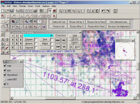
I've added some screenshots here of my own software, based on Oleg Kolbaskin's Vecad.DLL for 2D mapping. I have used it successfully to set up digs based upon scanned charts provided by the Fisher's to their sub-contractors to determine where NOT to dig, and to determine just exactly where I HAVE already dug, in order to eliminate terrain during an orderly excavation. My own software incorporates a conversion DLL, ProLat.DLL to convert from state plane 901, NAD83 to Geographic coordinates on the fly. As you might be aware, much of the aerial data you can now acquire is furnished in the standard local government format of state plane, so the ability to function in that grid is almost a primary requirement. I also want my stuff to run on less than stellar computer platforms without lots of expense, so I only write code for the functions I need in acceptable 32 bit Visual Basic. I have written some .NET versions, but, I can't spend the money on laptops that would be useful for the 3.5 framework. I buy used laptops, usually Toughbooks, that have been retired from police cruisers, and pick them up for spare change.
You can buy new GIS ware, or even the old 3.2 ArcView and get tremendous results. I highly recommend the platform written by the University of Idaho as a substitute (
www.mapwindow.org) for a suitable display/analysis program. Its free and works pretty good. It does lack the ability to translate to the common state plane systems or UTM. In Florida, that is essential, but you can get data expressed completely in straight Lat/Lon for some applications.
I've also armed myself with the Tatuk Viewer and the Tatuk Aerial Image Corrector from
www.tatukgis.com. Both have proven extremely useful, and I recently geo-rectified and mosaiced all of the 1943 aerials for Brevard County using my own software and the Aerial Image Corrector in conjunction with the Tatuk Viewer. Its always a hoot to overlay the old with the new to detect changes!!
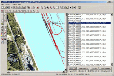
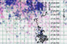
The screen shots: one is of my software plotting my MC5 mag data with the serial interface writing directly to ASCII, the next shows a working chart in my mapping software, and the last is an excerpt of a map showing the Fisher dig chart data as the base map with my own recorded holes as black crosses. Note the pink circles as already reported empty holes while the blue holes indicate holes where silver, in some form, has been recovered. The underlying grid is rectified to state plane from Geographic and each small tick represents about 6.4 feet.
The complexity and granularity of data now requires the use of digital management... you can not carry enough paper of suitable size with maps that mean something on the usual vessel engaged in this business. The computer is almost indispensible and the program you use is equally important.
What have been your findings in this regard to date?


